Getting a Final Dose of Autumn 2022

[Please note: Photos that go with this posting can be found in two links. The first is at https://www.smugmug.com/app/organize/SmugMug-2022-Fall-2 .Simply double-click on the first thumbnail photo and you will then see it full-size with caption. Advance using the swipe arrow to the right. When you reach the end of photos in this Gallery (it recycles to the beginning), then click over to here: https://www.smugmug.com/app/organize/SmugMug-2022Fall.

This is the last posting that willl be made for our hiking adventures, as we are shifting focus to travel beyond North America. We’ll let you know where and how those posts will occur in late 2023. Be well, dear readers!]

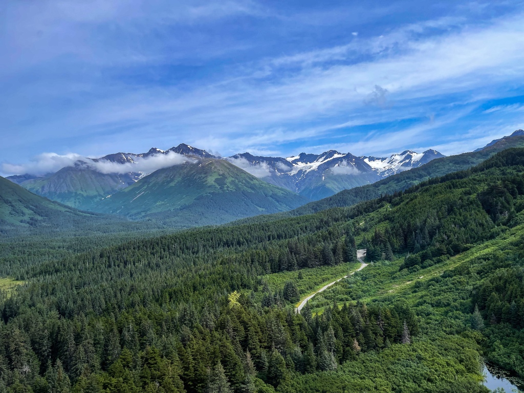
As y’all know by now, we totally groove on the mountains. And starting with our last driving trip to Sacramento to pick up the Moho (From now on we’re flying back and forth), we have grabbed the gusto of the ranges.

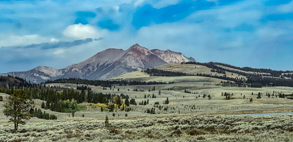
Admittedly, there aren’t many ranges in the Dakotas and even in Wyoming. Until you get to the far west side of WY, it’s mostly hills and gulches. But starting with the Fossil Buttes National Monument west of Kemmerer, WY, the gorgeousness of the Rocky Mountains starts to reveal itself. We ogled a few of the 500-million-year-old fish fossils and crustacean remains at the NM, and then headed to Park City UT for a night. PC has of course exploded with development and population since we were last there in the ‘90’s, but it’s still a beautiful perch in the Wasatch Mountains east of Salt Lake City.

The real prize came when we stopped in Elko, NV to redo our jaunt into the Ruby Mountains. Avid readers of the Goatrekkers blog may remember last winter when we mired our Jeep in deep snow on the road into Lamouille Canyon…but August is the perfect season for a retry, and we LOVED it!!! 

Lamouille Canyon is a 100-million-year-old glacially carved wonder, and someday the surrounding Ruby Mountains will be a National Park or Monument, they’re that gorgeous. We took a 2-mile hike upslope just to get ourselves acclimated to the elevation and stretch the muscles. Spied two golden eagles hunting and achieved some Zen, courtesy of the mountain streams. Didn’t quite make it to the high glacial lakes, but lunch by the stream was sublime. Our hotel that night in Winnemucca was also quite the thrill, as we crossed paths with the Geronimo HotShots, an elite group of firefighters from the southeast Arizona Apache reservation (near Chiricahua National Monument). These guys are legendary for their bravery and skill in fighting the most extreme forest fires. We were in the presence of greatness!!

——————————————————-

Once in Sacramento for 1.5 days of travel prep (stocking the Moho with food and dry goods), we took a break for some Farmers’ Market treats and a hike next to the beautiful American River in the Folsom district. 3.5 miles through the Jed Smith Riverbank Park suited us just fine, among the California Buckeye trees, fall fuchsia plants and live oaks. Lots of joggers, race-bikers, racing sculls, standup paddleboarders and hikers keeping company as well!

——————————————————-

Today we’re off to Yosemite NP, fleeing the 110-degree frying pan of Sacramento. We’ll see how much heat we can shed as we climb to elevation (Update: not much). Charred stumps from recent fires looked like black bears around every corner! This is ancestral homeland to the Miwok, Paiute, Yokut and Shoshone peoples.

Hah! At the western edge of Yosemite, the heat is still brutal. It’s the tail end of Labor Day weekend, but not everyone has fled back to the city yet. So, we’re picking our hikes very carefully and hitting the trails early. 

As usual, we did reconnaissance the first day to scope out the park’s center: Yosemite Valley. Decided not to go back until Tuesday when holiday crowds have thinned. Beautiful shots of El Cap and Half Dome in late afternoon sun, though. 😊

——————————————————-

Today we tackled Tuolumne Grove (25 old-growth Sequoias) and May Lake at 9,000-foot elevation along Tioga Road. Just perfect starter hikes for us as we ease into longer, more strenuous trails. Yosemite has two forest fires at present, the Rodgers Fire east of Hetch Hetchy dam and the Red Fire southeast of Yosemite Valley. The former appears mostly contained, while the latter is still raging and perhaps growing stronger. Smoke rising from them is visible along the ridge road.

——————————————————-

Reveille was at dawn today, as it takes a full hour to get from our campsite to the Upper Yosemite Falls Trailhead. Driving east into the park, the fire closest to the valley was clearly much worse today, as the sky was orange, and the smoke was even heavier than yesterday. 

Our trail target was a 5-mile hike up to Columbia Rock and back, ending in a spectacular outlook over the valley floor and major rock faces. But once on the path, we could see nothing in the distance due to thick fire smoke, which also made breathing very laborious. September brings millions of black flies to this park, and many of them were on the trail with us, adding annoyance to the effort of the climb. Two-thirds of the way up to Columbia Rock we headed back down. Just too little oxygen/too much smoke for a strenuous hike today. Instead, we scoped out Mirror Lake Trailhead for Thursday and walked a couple miles around the valley floor.

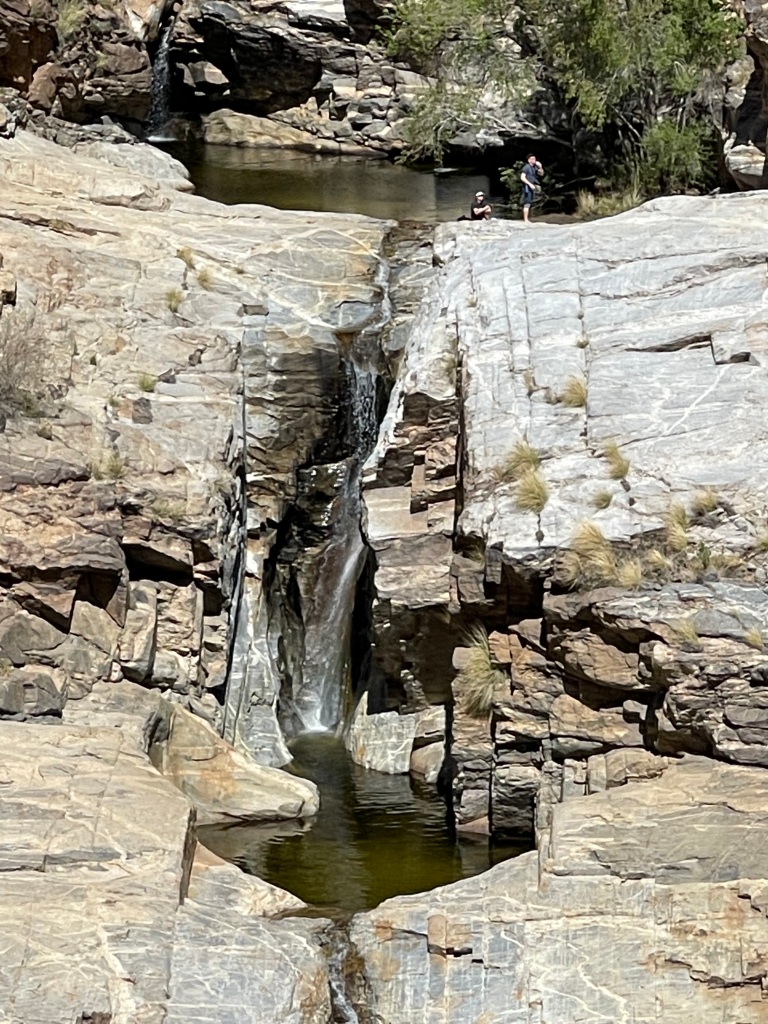
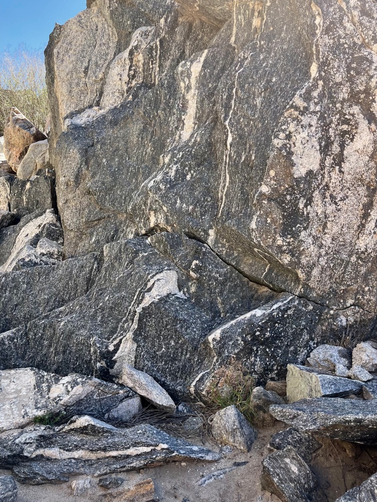
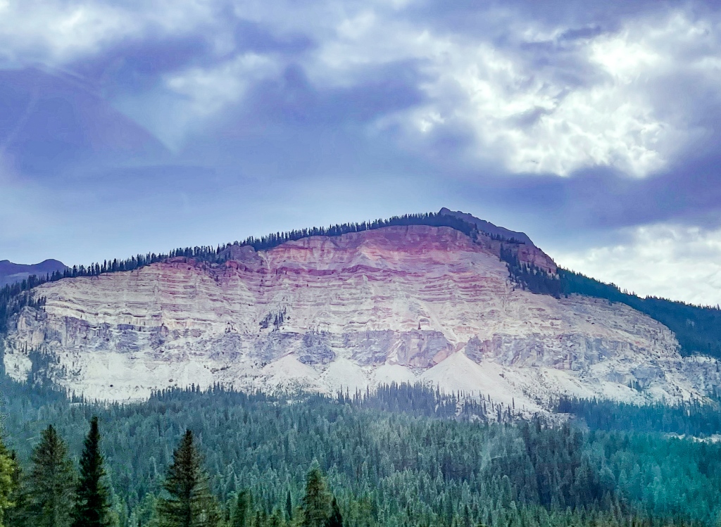
It must be said that Yosemite is a very unusual geological landscape, as national parks go. Its 38 towering domes, countless boulders, slabs and walls are dominant remnants of granite magma columns that slowly rose up through the earth’s crust but did not break the surface. As the upper crust eroded away over millions of years, the curious “fat missile” shapes seen in the domes emerged. Glaciers further eroded some of the dome sides, leaving walls like El Capitan, and millions of boulders and talus slopes. The granite here is mostly white (high quartz and feldspar content), except where prevailing moisture has stained the rocks a streaky black or encouraged lichens to grow. It’s just like nowhere else.

——————————————————-

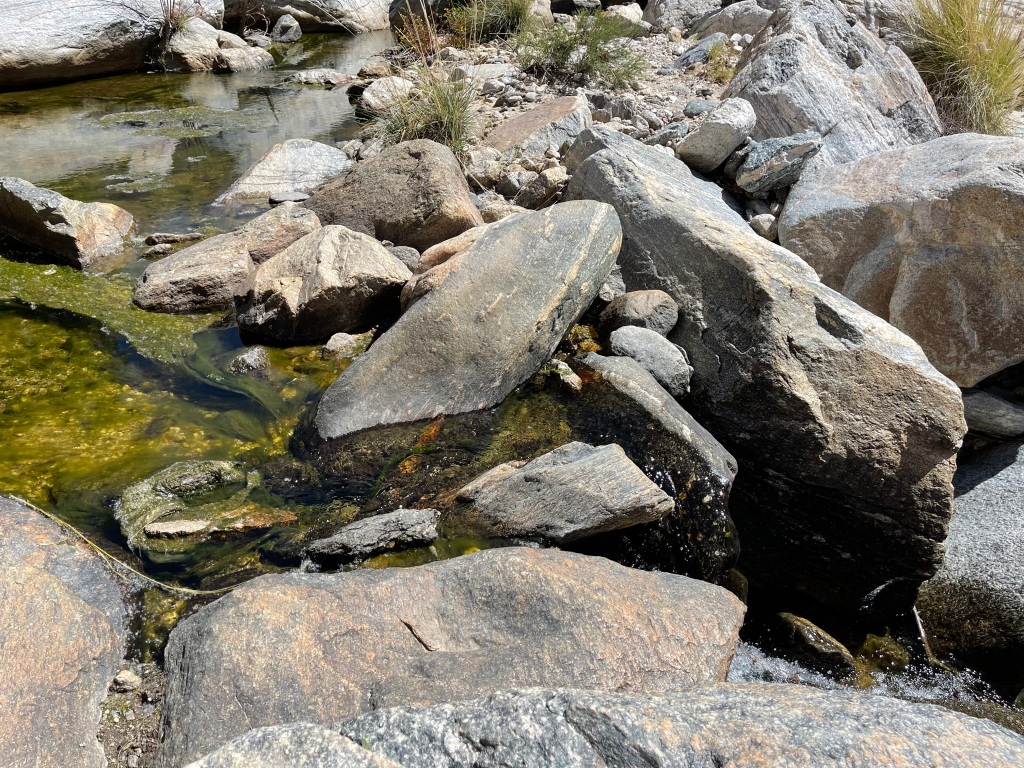
Today we got to the northern Hetch Hetchy Reservoir as early as Park Rangers allow, which is 8am for gate opening. Temp was 75 degrees, with a puffy popcorn cloud sky. Started up the north side of the water to see Wapama Falls (5-mile round trip), and by the time we returned to the dam it was 96 friggin’ degrees, and 105 degrees at our campground! Thank goodness for some trail shade from Sierra Junipers and Cedars, but the trees are dying here, too. The waterfalls dried up after mid-summer, but the rock walls themselves were just as beautiful as in the Valley. No wonder John Muir fought so hard to prevent Hetch Hetchy from being dammed.

We mostly had the rocky trail to ourselves on the way to the dry waterfall, except for two backpackers who’d been in the wilderness for seven days, a lovely swooping kestrel showing off for us, a lone mountain quail, white-shouldered squirrels, and a work crew building new wooden bridges around the Wapama water flow. Every year, hikers are swept downslope to a frigid demise in the reservoir when they ignore ranger warnings not to cross the bridges during snow melt runoff. The new bridges are intended to lessen the risk to all.

To be honest, in Yosemite nature seems to be playing a requiem for many of the park’s native plants and animals. Climate change, two decades of wrenching drought, and wickedly high summer temperatures are a trifecta force that is going to kill a good share of the trees that forest fires have not yet managed to burn. The natural burn-to-return rate is now 20 years, but the fires are so much hotter because of too much fuel. The granite domes and walls will endure, but a lot of flora and fauna will either migrate away or perish in the next decade, not to return for possibly hundreds of years, if ever. Yosemite of the near future will be a drier, hotter place, trending in the direction of Death Valley or Joshua Tree NP.

——————————————————-

After yesterday’s beastly weather, we opted for a rest day today and drove to Tenaya Lake on the Tioga Road. The Valley was rated hazardous for air quality, so no hike to Mirror Lake (rumor is that it’s more like a meadow now anyway).

Tenaya Lake is magnificent, clear and cool, full of fish, and deserves recognition for its own mirror quality. Depending on one’s vantage point, you can get a gorgeous reflection of Sunrise Mountain, Medlicott Dome, Polly Dome or Mt. Hoffman off the water, as they surround Tenaya. The wooded 3.5-mile trail around the lake is full of Mountain Hemlock, Jeffrey Firs, Lodgepole Pines, multiple varieties of heathers and heaths, and countless mountain azaleas!!!! They probably bloom before Tioga Road is open again in May….must be spectacular to see them against the white granite boulders!!

Saw numerous climbers up on the near-vertical slopes of Pywiack Dome, as they sharpened their skills. Wow. Never would we ever……

A short discussion with an experienced and well-informed ranger left us feeling better about the survival rates of some species in Yosemite. Apparently, Black Bears are doing well along Tioga Road, teaching their cubs to prey on the mule deer fawns instead of other animals who have become rarer. Also, the NPS no longer fights periodic infestations of beetles, moths and other parasites that kill off selected tree populations. It’s nature, and they let it be.

——————————————————-

We left Yosemite today via Tioga Road, filling our eyes one last time with the glories of Tuolomne Meadow (a large, high open space where the Miwok, Yurok, Paiute and Shoshone tribes met for shared ceremonies, meals and trade for many centuries), the granite domes of the Eastern edge of the park, and the abrupt and dramatic change in geology when descending from Tioga Pass to Lee Vining.

Now ensconced in Bridgeport, CA, we’re acclimating to high altitude hiking by beating the challenges of breathlessness, fatigue and overcoming cranky joints one day at a time in the high Sierras. First day was about scoping out our territory, visiting the Travertine Hot Springs, the 1849er Gold Rush town of Bodie (now a great ghost town), and inspecting the Virginia/Hoover Lakes area as a hiking target for tomorrow. Weather is blessedly back in the tolerable range, and likely to continue to a daily average of 75 degrees.

The Travertine Hot Springs just south of Bridgeport were wonderful, a real-time example of how silica-rich layered rocks like Agates are formed. The springs have been here in the valley for millennia, boiling up from the deep-water sources which heat the mineral-rich fluid to 110-115 degrees F. Multicolored silica deposits itself around the spring pools, forming travertine marble in amber, grass-green and white shades of translucent rock. To see this forming before one’s eyes is enchanting. The ultra-fine mud around the pools is EXTREMELY slippery, which caused George to do some rapid-fire balancing and interesting dance moves while getting his hiking sandals full of said mud.

We chose not to take a dip in the waters, as we’d been warned that they harbor bacteria which can lead to infections. But lots of others were there for the purpose of a good soak, contributing to an atmosphere much like a Grateful Dead concert. From the springs, we drove 13 miles into the eastern hills to visit Bodie, CA

As a ghost town, Bodie is much bigger than Tombstone, AZ (made famous by Virgil, James and Wyatt Earp), and Bodie’s purpose was distinctly different from the latter. At one time as large a city as 8,000 people, Bodie was filled with miners, merchants, schoolchildren, entrepreneurs, 10 to 15 mines, and yes, taverns and ladies of the night. Gold mining there and much of the population lasted until the 1920’s, then began to fall off and the gold mining ended in the late ‘30s. The state of California now operates it as an historic site and keeps the buildings stabilized as well as the furnishing intact to be viewed by the public. Amazingly, the townspeople enjoyed electricity, telephone service and running water lines from early on, long before many other communities in the state! In a word, wealthy!

Heavy rains and thunderous hail joined us on the drive back to camp in late afternoon, which ensured blue skies for the following day’s hike. 

Initial investigation of hiking in the Virginia Lakes area proved enticing, so the following day we returned to the 9,800’ trailhead in the Hoover Wilderness section of the Humboldt-Toiyabe National Forest. Our goal was to hike four miles round-trip, and every minute on the trail was superb. We gained 800’ in altitude and saw four gorgeous mountain lakes, nature’s bonsai forest at 10,600’, a multitude of very noisy Clark’s Nutcrackers, the very last blossoms of heather, monkey flower and lupine, and more scree fields that we have in a long time. Per my onboard Merlin app, we also heard Brown Creepers, Northern Waterthrushes, Mountain Chickadees, a Western Screech Owl, Rosy Finches, Golden-crowned Kinglets and Hairy Woodpeckers. We also saw a gorgeous Osprey who’d just fished his trout breakfast out of the lake and was hungrily digging into it.

A bird hunter who’d been up to Virginia Pass at 11,000’ and bagged two white Ptarmigans crossed paths with us. He’d hiked up there for the past eight years and only today found his targeted prey. So interesting. Ptarmigans were brought to the High Sierras in the 1970’s from Alaska, and as of today they are doing very well in this habitat. American Sage Grouse, a threatened species, can also be found on the sagebrush plains in the valleys of these mountains.

——————————————————-

The Yosemite fires just won’t quit, so once again we’ve got very soot-filled skies today. Hiking up into the Twin Lakes area should have been glorious, but we made the best of it on the Robinson Trail up toward Barney and Peeler Lakes. Winds cleared the smoke out for a bit, but heavy rain clouds brought a very low ceiling in and smoldering from the southwest finished the job of blocking sight lines. It’s ok, we had the most wonderful lunch spot to ourselves before returning to the car, and only had rain for the last 10 minutes of the hike.

——————————————————-

On to Mammoth Lakes today. Staying in a nice National Forest Service campground (Large camping spaces, no water, electric or sewer hookups) in town! Weather has definitely turned to the cool side now (60s daytime, 30s nighttime).

First of two hiking days takes us to Crystal Crag and Mammoth Crest Trail. It kicked our butts because we are still working on our altitude adjustments. It was only a 5.6-mile hike but gained 1500’ to bring us up to 10,500 summit elevation. Lots of lung-burning, breathing hard up top due to less oxygen, and the need to stop every quarter mile for our heart rates to slow to normal again. But this is typical on the front end of an adventure, so we’re not worried.

The immaculate Mammoth Crest trail wended its way upward via switchbacks through a mixed conifer forest of Lodgepole Pines, Ponderosas and hemlocks, then as we neared the top, every species gave way to white-barked pine (the preferred food of the Clark’s Nutcracker again!). Very little birdsong today, but the views of the glacial lakes were superb! Fascinating geology — we noted granodiorite boulders early on, which, as we moved upslope, were then replaced by cinders and copious chunks of pumice in many different colors. These volcanic peaks must have seen some explosive lava-ash throws, as the cinders and pumice were thrown 300 miles east from the peaks.

The sight of Mammoth Mountain, desolate, treeless, and coated in blond andesite rock on the south side, was quite surprising – the north and east sides are full of trees and ski slopes!! It is the biggest ski resort on the Eastern Sierra side. 

Also visible from the top of the crest are the sharply peaked metamorphic granite Minarets, the signature skyline of Mammoth Lakes. The minarets are fairly close to the famed Devil’s Postpile National Monument and its imposing jointed basalt columns. There is a great deal of nature and geology to see here!!

——————————————————-

One could only describe today as adventurous. The hiking was magnificent, but we started with the adrenaline rush of a bear encounter at the trailhead. George had gone back to the car for something forgotten, and I saw movement along the trail but no human head or colorful backpack. After 6 years’ hiking in bear country, I knew it was not a human but likely a bear. 

Sure enough, a juvenile black bear ambled down the path toward me, and so I started my deterrence measures. Raised my arms as high as they would go, started yelling “NO! NO! NO!” in my deepest, most threatening voice. The bear quickly ran off. Thank goodness.

Then the wonderfulness commenced, hiking up to Duck Lake off of the Coldwater Campground Trailhead. The clearest of blue skies, ideal temps for hiking (high 50s) and a lightly populated path. The trail is by turns hard and moderate, alternating rocky switchbacks with pine needle-littered straightaways over 4.2 miles upward. We passed five glistening aquamarine lakes and a meandering creek, then hit the rocky switchbacks for final ascent to the nearly 11,000’ Duck Pass. It is always a tremendous thrill to stand on the ridgeline between two valleys, and even though Duck Lake beyond is only a couple hundred feet below Duck Pass, it was magnificent to see into the distance on the other side.

Our path crossed with a pack string of obstinate mules, carrying belongings, food and beer up to the pass for multiple groups of fishermen on multi-day trips. We met the fishermen later hiking the trail. All younger than us and moving slower than us. It’s hard to stay in shape for altitude hiking when you’re still working for a living.

The down on this hike was a grit-teeth-and-bear-it 4.2 miles, as our feet and our calves are still not quite used to rock trails. But all was well when we found our ice cream cones in town. We hobbled home on sore feet, had a modest dinner and turned in early.

And there’s the rub.

We were so tuckered out post-hike, that some of our procedures lapsed. Forgot to lock the car. Forgot to take anything that smelled of food out of the car. Forgot to empty our backpacks of trail bars. And even though we had a pretty quiet night, the rangers knocked on our door in the AM and said, “A bear broke into your car last night.”

You can imagine that we feared the worst, coming out of the MoHo in our PJs. But we benefitted from enormous dumb luck – because the car was not locked, the bear didn’t have to break windows or pull off doors, he simply opened the car door and hopped in. He found nearly every edible item and ripped George’s backpack to shreds, but did not tear up the seats, punch holes in the leather or damage ANYTHING in the process. Dirt on the seats, dried drool on the seat backs and dashboard, and pine needles told us he’d been there, but otherwise, nary a trace was found. Just a few scratches on the outside, no biggie.

I’m still just a little hyperventilated from the break-in, but more importantly, we’ve vowed never to lapse in the removal of any food items (incl. wrappers, napkins, sandwich bags, even gum!) at the end of day. Even when exhausted. Wow, that was close.

——————————————————-

Now in Bishop, about 60 miles south of Mammoth. This is a town primed for tourists, with a nationally renowned bakery, kickin’ tourist bureau and plenty to do in the area besides hiking and fishing. 

Speaking of hiking, we knocked off two beautiful hikes over three days. 

First up was a 6.4-mile long hike up 1420’ to the Treasure Lakes area off of Hwy 168 (Bishop Creek Canyon). We are quite taken with trails up mountain valleys and canyons with glacial lakes along the way. Treasure Lakes is a verdant high valley with gorgeous Lodgepole and Whitebark pines, azure lakes and spiky cathedral-topped peaks for anyone who loves the thrill of dramatic geology. The trail is bounded toward the end by 12,000’ Hurd Peak, 13,000’ Mt. Goode and 13,000’ Mt. Gilbert. A more interestingly named peak is the Cloudripper at 13,500’, but we’re not sure whether we saw it or not.

For lunch, we reached our turnaround point at the end of a steep boulder-scramble up to a scenic and still-humid waterfall fed by the South Fork of Bishop Creek. We were able to scramble to a huge boulder sitting in the middle of the creek and admire not only the fetching waterfall and hear its music, but also to get an eyeful of the bounteous crop of bright yellow Monkeyflowers clinging to the creek’s edge. It’s obvious that the cleft where we sat is a riot of color for the very short blooming season (mid-July to mid-Sept). There was evidence of prickly poppies, lupines, paintbrush, pincushion, Sierra lily, penstemon, fireweed, aster, mountain mahogany, columbine…and on and on. We saw many gentian foliages, as well, but not until the next day did we see blooms.

Second hike was a close cousin to Treasure Lakes, but more arid and austere mountains. We drove back north to Rock Creek Canyon, always a GREAT source of fabulous trails. Last time here, we hiked the Mono Pass trail (stupendous), and this time we opted for Mosquito Flat to Morgan Pass. The geology alone was breathtaking, with so much metamorphic granite up in the mountain peaks.

With even more lakes along the trail than along Treasure Lakes, this hike enthralled us. And so many fisher people along the way!! The entire eastern Sierra makes big business from fly fishers, and many people do backpacking combined with fly fishing. And the wildflowers still hanging on amazed us. Finally, we saw a gorgeous gentian plant in bloom and several clumps of heather in their pink finery.

The hike started off cold, at 40 degrees with wind. High gusts started a mile in, and then the snow flurries began. It never let up from there. The streams were even prettier than the day before, but there was no lingering this day. We huffed and puffed it up to Morgan Pass, a truly desolate saddle at 11,100’, and when we reached it, took two quick pix, peeked over the other side (which looked like the surface of the moon) and hightailed it down again. Wore winter gloves and down vests the whole hike. 40mph winds gave us windburn.

George and I can both tell that the strain of these hiking days, and being around 70 in age, is starting to catch up with us. Aches and pains and fatigue are harder to recover from. So, we’re taking the next day off, and perhaps the day thereafter. The North Rim of the Grand Canyon awaits next week!!

——————————————————-

We drove down to the city of Lone Pine on Hwy 395 in order to eventually hike a trail close to Mt. Whitney, the tallest peak in the continental US at 14,494 feet elevation, and to visit the US Historical Site at Manzanar. Due to yet another bad rainstorm in Death Valley, it appears we now have to drive a lot of extra mileage to route around Death Valley National Park, since the only road through the park is closed for the third time this summer, 6 days ago. Continual checking on that road status did not save us from a surprise.

After a quick set up in our RV park and lunch, we headed off to Manzanar, the WWII Japanese “Relocation Center” or as we know it, Internment Camp. The scope of this odious operation in US history surprised us, as did the conditions to which the residents were subjected.

The camp operated for 3.5 years right after Pearl Harbor. It imprisoned 11,000 Japanese (Issei) and Japanese Americans (Nisei), mostly from the West Coast and Hawai’i. In 36 sections of 14 tar-paper barracks each, with 16 people in each barrack, the prisoners were forced to eat, sleep, and use toileting and shower facilities with others outside their own families. They were not allowed to cook for themselves, got lousy rations, and in some cases had to stop practicing their religion. 

Blowing dust is ever-present in this part of the Owens Valley. Today winds are gusting to 30 mph and our car doors are practically ripped away when opened. Can you imagine living in a tar-paper cabin (that might have been a horse stable last week), with nothing to stop the wind and dust? Water was scarce, wood was scarce and yet some people managed to repurpose fruit crates into very serviceable furniture.

Prisoners were subjected to taking a loyalty oath, be drafted for military service and/or forced to work in camp factories making camouflage nets for the war effort. All in all, the US deployed ten of these camps all over the West and Midwest, interning over 120,000 Japanese heritage people. Out of this population, 4,000 Japanese men were either drafted or volunteered, and fought honorably.

In 1988, President Reagan authorized a public apology to those interned in Manzanar, as well as a one-time $20,000 reparation payment. By then, only 60,000 survivors were still alive.

We are always glad to visit such historical sites because the stories must be told or we will repeat the episodes. But it makes us wonder if Congress would even authorize creation of a historic site such as Manzanar today, given our divisions.

——————————————————-

What an epic day! Crystalline skies with only the slightest clouds, 40-ish temps to start, and 10,000’ to gain!! This is our last Eastern Sierra hike for now, and we savored it.

The town of Lone Pine is Mount Whitney territory (tallest mountain in continental US), and we planned a two-day stay here just so we could go to the base and see it. All hikes that start at the Whitney Portal are just too strenuous for us today, but we did see it as up-close as possible. Stupendous.

Because this range along US 395 has so much variation in mountainous terrain, we didn’t have to go far for another hike that would be impressive. The Horseshoe Meadows trails south of Whitney were our goal instead.

These trails start out at 9,990’ and go up just 600’, through high meadows, lightly forested slopes and over several creeks. Why does it seem that mountain lakes and streams always look a shade of ultramarine that you never see at sea level? The water is electrically deep blue, just stunning!!

For almost a mile of our loop trail we were on the famed Pacific Coast Trail, and it was magical. Tall, thick and heavily weathered, the two widely spaced tree species up there are Lodgepoles and the relatively rare Foxtail Pines (looking like a relative to the sub-tropical Monkey Puzzle Tree!). Western Bluebirds can be heard regularly, and Black-Eyed Junco. 

We’d just passed a spectacular lookout down a miles-long meadow (most likely Horseshoe Meadow that the trail is named for) when a wiry young man came striding up behind us. A through-hiker who’d been on the trail since July at the Canadian border, he was headed toward Mexico. So exciting! 

The only way to meet up with through-hikers is either to see them at their resupply points or be hiking the PCT yourself. What were the chances?? We talked to him for 20 minutes, shared funny stories about hiking, then he went on his way and quickly disappeared in the distance. He makes 20 – 25 miles/day, every day, so can’t spend much time talking!

As it turned out, we only saw three hikers on our trail today, and two were through-hikers!

We ate lunch around Mulkey Pass (peak elevation for this trail), then started the descent into Horseshoe Meadow. Heavy rains had washed out the trail for ¼ mile, thank goodness we had Gaia on to keep us on track.

At the bottom of the descent, in the midst of the meadow instead of viewing it from above, we noticed how much coarse granite sand had been carried down by millions of years of snow melt and storm runoff. It’s enough to discourage any trees from growing at the bottom, as the ground is always shifting and getting more detritus on top. Pines are the only trees to successfully grow in sand, and up here, even they have to work hard to gain purchase. There was a lovely run-off and spring-fed stream, with dozens of bluebirds lounging in the grasses! More purple gentian (a family fave) scattered in the waterlogged meadow just put the icing on the cake for this hike. 

We have never done as many high elevation hikes in a row as during this adventure. No wonder it feels like Nature is kicking our butts some days!!

On the hairpin highway down from Horseshoe Meadow we got an eyeful of the dry Owens Lakebed. 110 years ago, Robert Mulholland of LA quietly bought up land in the Owens Valley near all area water sources here, and LA built a huge aqueduct to carry most of the Eastern Sierra’s water to the growing metropolis. 

Local farmers knew what was up as soon as the building started, and they dynamited the aqueduct dozens of times to stop it. But eventually, since what LA did was technically legal (even if deviously executed and bad for the environment), water removal won out and in 13 years, the 108 square mile lake was dry. Of course, this dramatically changed the character and livelihoods of Eastern Sierras residents. Just one of many water-reappropriation stunts in the long, unsustainable water use story of California.

——————————————————-

In Las Vegas only for as long as it takes us to resupply the Moho and move on. This is one of our least favorite towns due to heat, blowing dust, congestion and general gaudiness. But we have two great experiences here.

We’re staying in the Hispanic neighborhoods northeast of town, close to the Air Force Base. Great taquerias all around. Took George to his first Birreria and had heavenly street tacos. Birria is like Chuck Pot Roast with a little bit of chile seasoning tossed in. Soooooo good. I love it so much, I just ignore my beef allergies and aversion to meat for a night. Outstanding food. We have realized that if there is no English on the menu, it’s going to be the real deal.

We went for coffee before an appointment this afternoon, and a mother with three small boys walked in. We guessed the boys to be barely nine months apart, and they were cute in their matching black and white outfits and baseball caps. As mama ordered coffee, a ruckus broke out and the oldest boy hit the middle boy, who hit the youngest boy, who hit the oldest boy. This was not a game, they were by now really mad at each other and the youngest was crying. Mom did intervene to stop the cycle, but it had me laughing so hard to myself. Kids, especially when they’re not your own, can be so entertaining.

Last night we braved the Strip to go to one of José Andrés’ Vegas restaurants, China Poblano. George wore the World Central Kitchen Chef’s Crew shirt he was given in Tijuana, after we volunteered there, to show solidarity.

George ordered the tasting menu, a nice sequence of both Mexican and Chinese entrées, a tablespoon bite of each, and I ordered three Chinese dishes, because I didn’t want to overdo on Mexican given last night’s dinner. Just after George’s first bite arrived, Executive Chef Carlos and the restaurant manager came to our table and asked if we were employees of World Central Kitchen. We said no, we just volunteered in Tijuana for a week three years ago, and we donate to WCK because we believe fervently in their efforts.

Chef and the manager thanked us profusely, we had a nice 15-minute chat, and they left. Soon after, food started showing up at our table which we hadn’t ordered, compliments of the Chef. They brought two servings of everything George had on his order, so that I could taste as well. And two desserts. We loved it all and sent our thanks back to the kitchen. I can’t believe we didn’t blow a stomach gasket, eating all that food! Such generosity!!

It’s 96 degrees here and so we are leaving as early as possible tomorrow, with happy hearts and ready to get back on the trails!! 

——————————————————-

Now on the way to the North Rim of the Grand Canyon, we are passing through the Virgin River Gorge (eye-popping, beautiful slot canyon that has been widened for the highway to go through), St. George and Hurricane UT and Colorado City, AZ. It’s challenging to figure out which state and time zone you’re in as you traverse the Arizona strip and SW Utah to get to the canyon. The last few miles we found ourselves once again up against the Vermilion Cliffs – you never forget these sumptuous and saturated red colors!

We’re stopping at Pipe Springs National Monument and to see the Toroweap Outlook in the Grand Canyon Parashant National Monument. Two days with the Kaibab Paiute Indians in their wonderful campground here.

We visited the Pipe Springs NM our first night here, and came away saddened by the last 150 years of history. For millennia, the Paiutes had lived peacefully in this high desert and made use of the consistently flowing clean spring to water their crops and meet their needs. Mormon settlers homesteaded here, in line with US government policy on colonizing the West, and around 1860 they built a fort, called Windsor Castle, over the top of the springs so that they could control all of the water. Deprived of this very scarce resource, the Paiute had to move away from Pipe Springs and this caused considerable hardship for the tribe.

As the NPS ranger further explained, by the 1890’s the Mormon settlers were ready to move on and relinquish the fort and its outlying buildings, but they would not give it back to the Paiutes. They sold it into private hands and 20 years later, the National Park Service bought it for historical preservation.

Today, we spent the day driving out to the Toroweap Outlook over the Grand Canyon’s northwestern end. The drive itself is “only” 60 miles, but the road and the rules only allow speeds up to 35 mph. The road gets progressively rougher the further one drives, until it is almost like rock-climbing for 4WD high clearance vehicles out at the end.

But what a drive!! Photographs cannot convey what a spectacular journey you have along these 60 miles. The grasslands still seem to house the spirits of the hundreds of thousands of buffalo who would have grazed here. This is early fall, and you can see that the grasses have ripened and the fuzzy grey forage called “Winter Fat” is in its glory. This is critical graze for livestock who overwinter here. 

Ancient wild amaranth is everywhere, and when you put it next to cultivated amaranth, it’s amazing that the tribes could ever get useful flour from the ancient plant. But they did.

The stony hills with capstones and ridge foretell the drama of the Grand Canyon geology to come. Because this area has gotten above-average rain in the past three weeks, fall wildflowers are thickly carpeting the meadows. Lots of lava evident from past volcanoes. This is prime territory for backpackers wishing to hike in the wilderness for days, and we’ve seen several caravans of Jeeps who appear to have done just that. Other than that, this place is filled with solitude, visual drama and quiet splendor.

We neared the Outlook but did not complete the final two miles, as our rear right tire picked up a small puncture on the way out and we thought it best to catch the beauty already perfectly evident in the distance from where we were when we assessed the tire damage. Luckily, the rocky perch was the perfect lunch spot, and we ogled the nearby mountains and deeply carved Western Canyon layers as we munched. Then it was back in the Jeep to try to keep the leaky tire sufficiently inflated to make it out. Eventually, we had to change the tire, but nothing worse than that.

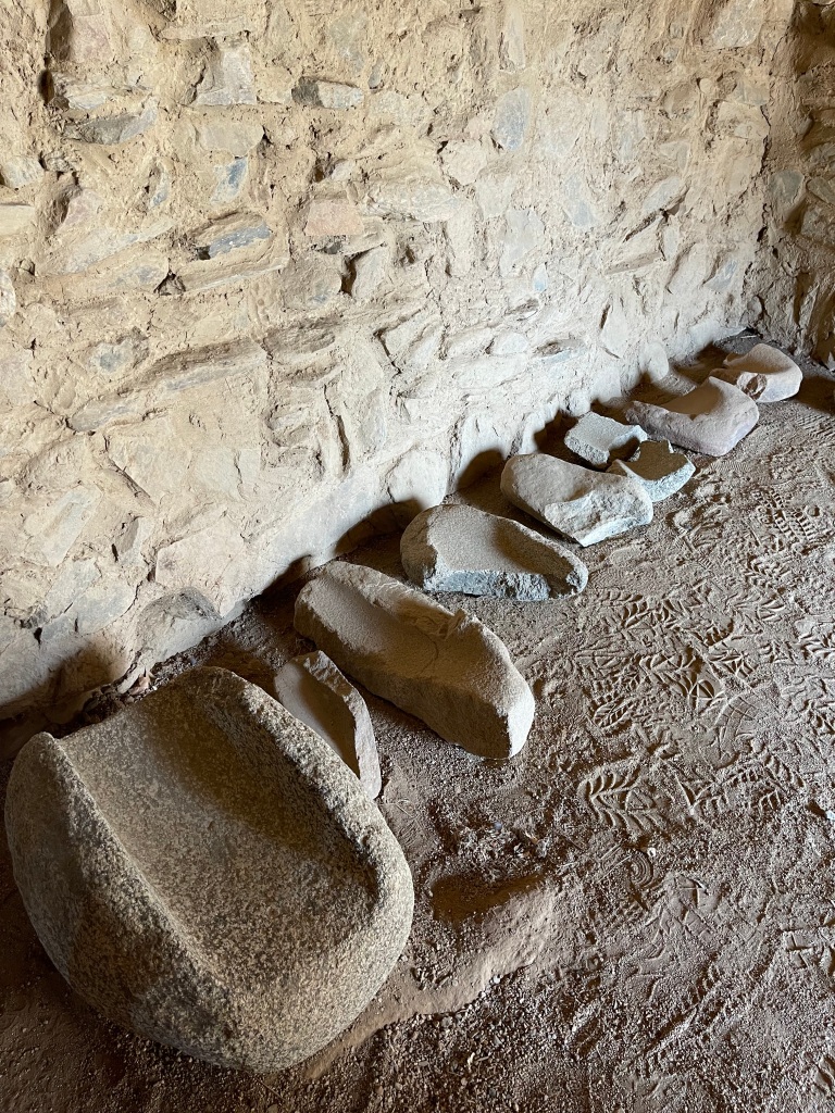
The Paiute operators of this campground have thoughtfully built a rock garden on the grounds, and it displays the great diversity of rock found in the area. What a treat for the eyes. 

The terrain of this area is so captivating, it draws us back here time and again. Although it has much in common with other deserts we frequent for their spectacular geology, it’s unique in the spirit seeming to be present in the stones, the air, the colors that morph over the course of the day and seem to intensely glow in the afternoon Golden Hour. What stellar wilderness we are privileged to see.

——————————————————-

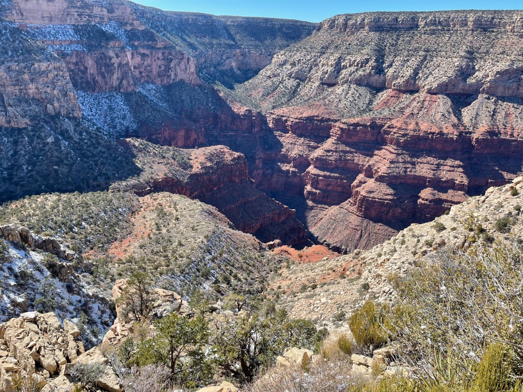
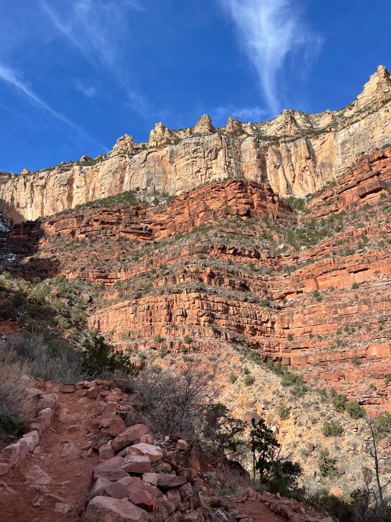
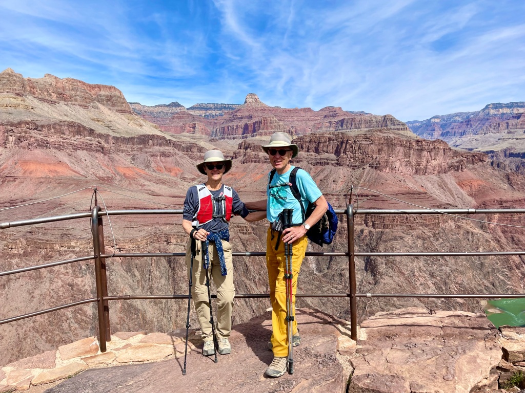
Up at 5:30am today for a repeat of the North Kaibab descent into the Grand Canyon, which we first did in 2020. This is a HARD hike. Down and back up 3,894’ and total mileage 10.42 miles. Six and a half hours strenuous hiking. Average 14% grade.

We were hoping for cool weather all day. And it was cold to begin, 38 degrees with light wind. Drove the 20 miles to North Kaibab Trailhead and got the last parking place. It’s obvious a lot of hikers go all the way down to Phantom Ranch, stay at least one night, and either hike back up the same trail or hike up on the south side. Their cars fill the lot.

Having done this trail once before, we can confidently say that the 5 miles down and back are the hardest part of the trail. This is where most of the elevation is gained or lost. The rest of the 13-mile North Kaibab down to the river is mostly flat. Not discounting the degree of work involved in the whole hike, but the first five miles are the most grueling.

Today was a gorgeous day, sunny with mostly clear skies, and air temps warmed up fast. Unfortunately, it’s always 20-40 degrees warmer in the lower part of the canyon, so by the time we got to our destination at Roaring Springs, temps were probably at least 75, headed toward 90. That’s excessive for us and takes most of the joy out of the hike.

The gnats/black flies of Yosemite are here too, clouds of them. But an intermittent breeze mostly scattered them away from our faces.

We oohed and ahhed again over the amazing temple-like structures of North Kaibab, the deep reds, intense oranges, light blues, turquoise and moss greens of the walls as we descended. With so many millions of years of rainwater (with heavy mineral content) pouring down over these rocks, it is easy to see how the onyx, agate, chert, colored quartz veining and other semi-precious surfaces formed on and in the base sandstone and limestone walls. It’s like being in a gem shop, except you can’t buy or keep anything!

Aspens and Rocky Mtn maples are bright yellow and scarlet, and as you hike down the canyon trail, you traverse all the climate zones found across the 4,000 feet of descent. Woodland vegetation gives way to subtropical and desert plants. At the same time, you are traversing almost 4 billion years of geology. Quite a heady experience.

We hiked all the way to Roaring Springs this time and had lunch at a quiet stream. Heard Canyon Wrens, Stellar Jays and Townsend’s Solitaires calling to one another, but didn’t take time to track and ID any other birds because we were too focused on hiking back up before it got any hotter.

Honestly, this time the hike up was positively brutal. The temps rose higher than forecasted, sun was intense and George’s arthritic hip caused him a lot of pain during the climb up. We encountered several sets of hikers who were much worse off than we were due to overestimation of their own readiness for the trail, and one hiker needing medical attention due to fatigue and likely heart problems. We were well-prepped for the hike and have been hiking at altitude already a month, but due to COVID, we’ve not had our normal strength-building workouts at the health club. It shows. Endurance and strength overall are not where they needed to be for this hike. At our age (68 and 70), if you are not building muscle, you are losing it. Back to the gym!

——————————————————-

A tip for those wanting to strike out on obscure trails to discover more than the top ten hikes in a National Park: go to the Back Country Permit Office and ask for maps of less-known trails you can drive to. They generally have maps of Forest Roads, and providing you have a 4WD high clearance SUV or Jeep, you can enjoy these during your stay! We are doing just that today, going to the North Rim twice for overlooks seen only by backpackers!

Wonders await anyone who braves the rocky, rubbled, root-infested and ravine-garnished forest roads!! Oh, the roads! So glad we swapped our worn tires in Kanab for 6-ply Baja Champion trail-grade tires! Most of the roads traveled today had limestone cobbles ranging from 3” diameter to the size of a big acorn squash. Add in bedrock outcrops, stumps, thick roots, washouts that could swallow a bowling ball, muddy puddles and drop-offs that took all of our 9” of clearance, and you have NASTY! But we’re going back for more two days from now!

The woods surrounding are pretty much exactly what the rangers say a healthy forest should be: mixed deciduous and conifers, well-spaced, young and old, with brush and occasional open meadows. The aspen are breathtaking and the New Mexico locust trees are ok, too, if one must have thorny locusts. Cliff roses, scarlet gilia, lake daisies, cardinal flowers, lavender tansy asters – just lovely. No bears seen, but two mule deer jumped across our roads.

We hiked part of the Powell Plateau trail today, would have loved to do it all but the heat was against us. The most gorgeous chert, flintstone and agatized limestone fragments are along the trail and at the trailhead. Very tempting, but as always, we’re leaving them for the next visitors.

Met David Letterman’s doppelgänger at the top and traded stories for a bit. He’s 78 and just climbed Mt. Washington, Arizona’s highest peak. How inspiring!

One thing we’re convinced of: the North Rim has deeper canyons and more of them than the South Rim. It’s 2000’ higher, heavily vegetated, and very diverse in its scenery and vistas. We’d come back here again and again. BTW, there was a buffalo cull hunt here last year, and as a result the bufffalo are very wary of humans and make themselves scarce. Good plan.

——————————————————-

Today we got a late start on hiking the Widforss Trail, a 10-miler that is mostly at the rim around what is called the Transept canyon. Gives hikers a 270-degree view of a long canyon that intersects at 90 degrees with the path of North Kaibab/Bright Angel. A stunning set of walls, standalone towers, tall parapets and the long, lush valley below. We made it six miles and had to stop, or we’d have been returning in the dark. Luscious and changing views of the Kaibab limestone, Coconino sandstone, Hermit Shale and Redwall limestone!

——————————————————-

Last day of hiking on the North Rim, we headed to a set of forest roads leading to various segments of the Rainbow Rim Trail. Took these routes on the far western side of the Park, as recommended by the Back Country Permit Office, and they were not as treacherous as those taken to Point Sublime, Every road was lined with now butterscotch-colored Aspens, just about at peak color. We reached three trailheads for the “rimmiest” segments of the 22.5-mile (one-way) Rainbow Rim Trail. Weather was near-perfect, density of gnat swarms was thick as pea soup. 

Starting with the northernmost Parrisawampitts Overlook Segment, we marveled at how soft the Grand Canyon walls and plateaus seemed to be, blanketed by Piñon Pine, Cliff Roses, Mountain Mahogany bushes and agaves. Moving next to Fence Point Overlook Trail, our favorite, we ogled the colorful flint rocks lining the trail and applauded the wildflowers for still being in their glory. By this time, I had decided to don my head net over the trusty Tilly hiking hat and was blissful despite the gnat hordes for the rest of the trail. The landscape at Fence Point looks astonishingly like the Tea Plantation Terraces in the Sichuan Province of China! Finally, we finished up on the Locust Point segment where limestone towers abound all along the rim edges.

According to the Park Service, there are 17 raptor species with territories in the Grand Canyon. We saw very few, and surmise that hunting in the vertical parts of the canyon is very difficult for them. We did, however, see and hear many Townsend Solitaire warblers, nuthatches, chickadees, flickers, Stellar Jays, wild turkeys, and ravens, of course. Three birdwatchers at our campground pointed out the red-winged crossbills in the golden Aspens. On the way home last night, a lone coyote crossed the road in front of us. It bears noting that ALL of the prey and predator animals we have seen are in VERY good shape heading into winter.

As should be with any favorite place to be, we’re sorry to leave Grand Canyon North Rim, and certain we’ll be back.

————————————————-

Today was all about the water. To be more direct, about the rain. What a rare privilege to witness two rainstorms in the desert!!! One on the outskirts of Page, AZ, and the other while driving across Navajoland to get to Bears Ears National Monument. Wow. Hard rain, soft rain, thunder, lightning, rainbow and beautiful sunset. 

Never did we expect to see standing water in bedrock depressions, streams building in washes, and rivers gushing in torrents – in the desert! We’ve been safe the whole time, not crazy enough to take a tour through Antelope Slot Canyon (but judging from the parking lot, there are lots who are!!). Just excited for the ground, plants and animals to get this soaking before the 8-month dry season begins in December. It may not seem that big a deal, but the area has seen its monthly total rainfall in two days. Flood warnings are out, and terra cotta-colored water is everywhere.

Along with the storms, we’ve gotten the most dramatic skies. Sunset was breathtaking last night, moody low clouds settling over the mesas, and crazy cumulous parties in the sky!! Add in the arrestingly beautiful sandstone monuments in the desert (and an occasional painted pony or appaloosa) and you have real magic.

We’ll see how the moisture affects the roads we want to drive in Bears Ears. Word is, some of them have been washed out. Upon arrival, had a great orientation chat at the Friends of Cedar Mesa Education Center in Bluff, where we’re staying. These folks have done yeoman’s work to help the Inter-Tribal Coalition keep Bears Ears protected. It’s good to visit with them.

————————————————-

Two key phrases for this week’s explorations into Bears Ears Monument:

“Not well marked,” (regarding the ancient sites) and “Looks like fair skies so far.”

We had a great first day in the Monument, driving the Trail of the Ancients all the way around Cedar Mesa. Decided early on to focus only on Cedar Mesa, because the monument is just too big to investigate all of it in one week. 

The day started with beautiful blue skies, and we drove the three-mile Moki Dugway Hairpin Highway to get to the top of Cedar Mesa. Incomparable views out over the flood plain of the San Juan River. Took the dirt road out to Muley Point. What an amazing peninsula over the meanderings of multiple rivers and washes. The peninsula point is all slickrock, and at one point I laid down on the rock to inch close to a sheer drop over the side. What a great surprise, there was a broken slab 20 feet down, with petroglyphs on it!!!

This is what happens to those who go slowly and with great curiosity through Bears Ears. Archeological sites are “Not well marked,” and one must prepare to be surprised.

Bears Ears has over 100,000 sites (ruins, buildings, kivas, etc.) associated with the indigenous peoples who have lived here, on and off, for 14,000 years. And 99.5% of them are unmarked and not on any maps, to protect them from looters and vandals and just plain careless visitors. So, one must be open to what lies down an unmarked road and visit with great respect and care.

A stop at the Kane Gulch Ranger Station gave us more hints about where to look and what not to miss. By this time, we’ve identified (through research and discussions) 21 targeted sites to visit. Whether we’ll find them all remains to be seen!

By noon, the blue skies had disappeared behind angry charcoal storm clouds that threatened to cut short our visit to all three of the sandstone bridges in the Natural Bridges National Monument. We had to race-walk out to each of them (Sipapu, Kachina and Owachuma) and back to the car, finishing up at the Visitors’ Center just as giant raindrops started to fall. Lots of thunder and lightning over the Bears Ears Mountains, which just seemed to increase their spiritual energy.

Driving east, we stopped to see the Upper Butler Wash Ruins, an amazing remnant from the Ancestral Puebloans living in these cliff dwellings 700 years ago. This must have been a primarily religious site, as it featured four kivas with numerous living quarters behind the kivas. Stylistically it resembles the Mesa Verde structures. Very impressive.

You can’t help but pass white settler buildings from the 1800’s while driving this route. Although some would argue that these, too, are part of our history, we feel that the legacy of colonialists displacing the tribes, many times violently, is difficult to respect in this place, and that Bears Ears has always belonged, culturally and religiously, to the five tribes who proposed it as a national monument in order to protect it. The Hopi, Navajo, Ute Mountain Utes, Paiute and Zuni people have 14,000 years of history here. This is what we came to see.

————————————————-

Today was another beautiful blue-skies day, and we used it to view the gooseneck meanders of the San Juan River, at the State Park and out on a trail called Honecker. These nearly-360-degree curves are among the world’s most severe embedded meanders, and they are beautiful. The rocks along the slopes are not nearly as colorful as elsewhere in Bears Ears, but the geological phenomenon is what most people drive out for.

Because of a delayed start this morning, we ended up on the Honecker Trail just as the day began getting really hot, so we opted for less than one mile on the nearly vertical slope. The San Juan is extremely muddy due to rains, and we’ll see the river up close tomorrow during a kayak run, so we cut Honecker short. And it’s probably a good thing we did, because driving back to the highway we came across a guy in a two-wheel drive van who could not make it back up one of the steep hills on the route. George used our Jeep’s very long tow belt to pull him up the last 20 feet and that was enough to get him clear of the hill.

We’ve had plenty of people help us when in need, it was time for some payback.

From there we drove another five miles along the plateau that was (vertically) halfway between Cedar Mesa and the River (prob. 1000 feet up to Cedar Mesa from there and another 1000 feet down from the road to the River). Called John’s Canyon, this road is for anyone who wants to witness the incredible carving power of water. So many pore-overs, washes and waterfalls down to the river, it is spellbinding to see how the landscape changes with various forms of erosion. We reached the bottom of the Muley Point heights visited two days ago, and then the road got too gnarly even for us. 

It’s much more colorful around Muley Point than at Goosenecks Park. The reds are vivid and saturated, ranging from carmine to scarlet to burnt orange to chili pepper and maroon. Then there are the turquoise-colored layers. Don’t get me started on those!

Driving around here at different times of day has given us great perspective on the towering stones, cascading cliffs and dominating colors, both bold and muted, that are so characteristic of this place. Very spiritual.

————————————————-

Today was to have been our San Juan River kayak tour of some of the ancestral Puebloans’ petroglyphs and ruins best visited by water. But the rains of the past week turned the kayak takeout point into quicksand. No really, it’s quicksand and very dangerous. So, we wait for that spot to drain and dry out, possibly by Sunday.

Instead, we drove up Lower Butler Wash Road, one of the very best access roads to see cliff dwellings and petroglyphs. I will not reveal here exactly where the ruins and rock art are located, because visitors really need an orientation and instruction on how to respectfully find and visit (from a distance) the culturally and historically significant sights of this region. But I can tell you about the hikes to get there and share some photos that have no GPS tags – it was a glorious day and we’ll be going back tomorrow for more hiking and viewing!

In most cases, one has to know approximately where each named sight is. Remember, they are generally “not well-marked.” Then one drives back on an unsigned bumpy dirt road (4WD strongly recommended) and endeavors to find a trailhead. Be careful you don’t follow a cow or deer path! Then it’s generally 1 – 3 miles west toward the Comb Ridge, upslope on slickrock, until you reach a canyon –if you’ve done it correctly—with either petroglyphs (symbols pecked through desert varnish into the face of the stone) or cliff dwelling ruins or both!

We were able to do this twice without messing up. First revealed was a very famous wall of petroglyphs called the Wolfman Panel (see photos) – Wolfman is a two-foot-high male figure who appears to be dancing, and he is surrounded by sun images, faces, other figures, sheep, etc pecked into a high wall of red sandstone. Quite impressive, even though some of the panel was damaged by gunshots fired by disgruntled US Army soldiers who had to defend the settlers from those whose land they were stealing (or so the story goes). The cliff dwelling ruins were not too far to the north.

Next, we found the Double Stack House, also up-canyon from the road and about 3 miles away from Wolfman. This site was deserted. No petroglyphs, no detail on whether the dwelling also had a kiva, but rooms pretty well intact although roofless. On the opposite side of the canyon were bore-holes in the wall to accommodate Bigas (large beams to hold up the roof), so we know there was a dwelling or granary opposite the Double Stack House as well. Walked a bit further to see if petroglyphs were present, but instead found a large uninhabited alcove that may have functioned as temporary shelter or a gathering place for multiple families to meet and socialize.

There are NO brochures or paper guides, often no marked trailheads, and no stories or details available for these sights. The tribes, the US Dept of the Interior and the Friends of Cedar Mesa are not making it easy for seekers to visit the ruins, simply because too many looters, vandals and pot-hunters have already been here, to the ruins’ great detriment. You HAVE to do your research, talk to the experts, consult books and maps in order to be successful. Today we encountered three people who said they’d been visiting these sites for 40+ years and have recently noticed that visitors are now more educated in the protocol of careful visitation and more respectful of the sacredness of the area to the tribes.

Our final attempt to visit a well-known but “not well-marked” site did not succeed. We were off by 600 feet on where the trailhead should have been, and as a result we found ourselves in the stickiest mud ever encountered in a dark and dank wash/one-time swamp! At the end of our fumbling around, we did indeed find the trail but by then we were so hot, mosquito-bitten, mud-caked and tired that we decided to leave Monarch Cave Ruin for discovery on another day. Best to know when you’re beaten.

Lots of gorgeous geological eye candy today, we even saw a Long-Nosed Leopard Lizard eating a smaller red lizard for breakfast and heard the cries of Northern Flickers, Yellow Warblers and Lesser Vireos, Sparrows and Finches. For those who are curious, the Comb Ridge is a very rare sandstone monocline, 120 miles long, and the second largest in the world. What a cool sight it is to see!

————————————————-

What an absolutely magical day!! We made it to the top of the Comb Ridge west side plates AND viewed the spectacular Procession Panel Petroglyphs on the way up to the top! One of our best, most breathtaking hikes ever.

With mixed feelings, we looked up the approach instructions for Procession Panel Trail on the AllTrails application first thing this morning. The trail was recommended by two hikers yesterday. The good and the bad about the AllTrails listing is that now anyone can find the trailhead and hike up there, whether they have any info about how to be a respectful visitor or not. The Internet makes short work of accessing cultural treasures.

There are so many beautiful canyons in Comb Ridge, it would be easy to overlook this one. “Not well marked.” We headed up the trail at 10-ish in the AM, slogged through the now-drying mud in the wash before getting to more than a mile of slickrock rising 620’ to the Panel itself. 

What is so special about this panel? Its size, complexity and incredible narrative.  Created sometime between 500 and 700 AD, this massive petroglyph is 40’ long, on a high vertical wall, and contains hundreds of human figures all converging on what is thought to be a large Kiva. The scene also includes bighorn sheep, possibly camel-like creatures, men carrying ceremonial staffs, women and children, fletched spears, and images that have yet to be interpreted. It is impressive that the artist rendered the long marches of figures joining together at the Kiva in diminishing size, so that there is perspective out to a vanishing point. One feels awed, looking at this early masterpiece. Easily the richest storytelling petroglyph we’ve ever seen.

From the Panel to the crest of the Comb Ridge is only another 200’ or so of vertical rise, so we hoofed it up there on steep slickrock to the very top, where the expanse of Cedar Mesa, the Bears Ears twin mountains, Monument Valley, the southward curve of the Comb Ridge, and the western wash of the Ridge laid out before us. The vantage point of a Golden Eagle. 

Behind us was the eastern side of the Ridge, along with the domed plate structure upon which the Panel had been pecked into the rock. Just as spellbinding as the western sweep of land.

One way to think of this massive (80-mile long) ridge structure is to imagine a seismic event that faulted the earth here 60 million years ago and sucked the western side of the fault under the eastern side. When this occurred, the eastern side rose up 700’ into a series of huge, broken sandstone and slate plates. As rains and snowmelt ran down the Ridge over millennia, large canyons were worn  between the plates. 

The drama of the Ridge lies in its abrupt rising from the desert floor, the rakish 20-degree angle of its plates, and the beauty of its sinewy canyons. One of a kind in the western hemisphere.

After the Procession Panel, we went to the Monarch Cave Trail to finish what we started yesterday. It’s a very easy trail, following the gentle bed of the canyon wash for about a half mile, then rising to slickrock for a quarter mile before stopping at the canyon’s box end. There sits a magnificent ruin of a large communal cliff dwelling in a deep alcove (cave), which has been reconstructed by archaeologists so that you can imagine more of what it was originally than many ruins in this area. Looks to have had multiple round Kivas. In a neighboring alcove are piles of rubble and a few intact walls. This was likely an extension or later addition to the cliff dwelling, but it has been destroyed by looters and vandals.

Many dwelling ruins now have fences or chains around their perimeters to discourage visitors from entering the fragile structures. But some folks just choose to climb over them, thus there will continue to be deterioration. Seems even more education and persuasion is needed to keep respectful visitation growing.

As has happened most nights here, again storm clouds gathered in late afternoon and we had another glorious sunset. Desert skies are something very special.

————————————————-

Today was the last independent day of exploration in Bears Ears 2022, and we fell victim to a routing error on the part of AllTrails. But all is well, we had a wonderful 6-mile hike on the west side of Fish Creek Road. No ruins, no petrographs, just beautiful views of red rocks, the west side of the Comb Ridge, and luscious turquoise, chili-pepper and deep blue colored chert/agate/petrified wood rocks in the washes. No samples were taken, but my mouth watered for them all morning!

Tomorrow and Monday we have scheduled guided tours in the area. Our introduction to Bears Ears has been magnificent, and we still have MUCH to discover here. We will be back!!

————————————————-

Last two days on tour have been extra-special. We spent a day on the San Juan River and up on its banks with Ian and Raquel, two twenty-something Navajo guides with lots of local knowledge, cultural background and eagerness to share information (Wild River Expeditions). Saw the famed Kachina Panel, the site of continuous petroglyphic communication from 2000BC to 400AD, and the River House, an ancient dwelling that housed up to 60 people at a time between 700 and 1200AD. The road back to town is barely a road, mostly shallow river, big rocks and mud. So the trip back to our car in their open Hummer with jump seat was the wildest part of the day!

The following day was spent with Louis Williams, Navajo owner of Ancient Wayves River and Hiking Tours. What a jewel of a guide he is, with deep convictions, a passion for his heritage, and a desire to educate more people about indigenous ways so that there can be more respectful visitation and cooperation between peoples.

Louis took us to sites on Cedar Mesa that most people don’t know about and/or don’t visit. The hikes themselves were gorgeous paths through washes, pour-overs, springs and canyons. Two different ancient dwellings with kivas or kiva remnants, petroglyphs and pottery sherds buried in the loamy ground around the sites. 

The information Louis shared about his language, upbringing, how the Navajo Nation governs itself, how the Interagency Tribal Council is starting to manage the Bears Ears National Monument, history between the tribes, and his plans for the future/his kids’ futures was deep and impactful to learn about. We are so pleased to see how he is operating his business and working to bridge misunderstandings and misconceptions about the significance of Bears Ears to humanity.

Examples: Louis has taken Utah Congressional representatives on personal tours of the indigenous sites in Bears Ears. He guided a whole congressional delegation who were investigating the possibility of this land being a national monument, met across tribes as the Council was being formed, worked with Cedar Mesa on preparation of the monument, and has brought the leadership of the Blanding Uranium Processing Plant to vulnerable water sources in the monument to impress upon them the importance of keeping ground water unpolluted. He gets around and has made an impact on the future of SE Utah.

He also shared some of the economic and policy issues in the Navajo Nation. If you have ever wondered why the tribes have such humble dwellings and it seems as if they don’t take care of their property, keep in mind that most Indigenous peoples in the US are extremely poor, don’t even have running water, have to travel miles to refill portable water tanks, and most often live in FEMA trailers or substandard housing that the government provides. This is because we have confined them against their wishes on reservations, where unemployment is sky-high. Lots more to this story. Also, the Navajo Nation doesn’t want its reservation to become checkerboarded with private holdings resulting from sales of tribal land to non-Indians. So, natives can only get a 99-year-lease for property and only will that lease to their oldest children or family members. There is, in effect, no real estate industry on the Res and no possibility to sell one’s home with land. Thus, many Navajo prefer to live in trailers just in case they might need to move to another area on the Res. It’s complex, and difficult. 

While out with Louis, we saw too many Anglos breaking the rules of the monument: running their dogs loose to sniff and soil the ancient dwellings, running OHVs and motor bikes where no vehicles are allowed, writing graffiti on the monument signage. Much more education is needed so that people understand how rare and valuable (as well as fragile) this land is.

—————————————————

A drive to White Pocket, AZ, on the Paria Plateau, is like a trip to another planet. A planet that’s gorgeous and clean and spellbinding and as old as the Jurassic time period. 

It takes a long time to get there in a high-clearance 4WD vehicle, which is the only way you can get there – 2.5 hrs one-way. The roads there are not THE worst we’ve ever seen, but very challenging and highly varied conditions. Most folks who make the trek do it through tour companies, but the price tag is $750 for two people, so we took our best GPS mapping and tracking tools and did just fine. Apparently some folks who live out there are good and tired of visitors driving across their property, so the BLM has erected signs that state in large block letters: “This is NOT the road to White Pocket.” Never saw that before.

White Pocket, according to geologists, is the result of a dinosaur-era seismic/volcanic event, wherein a gigantic sand-slide descended on the sandstone bedrock of the area and became compressed into stone over hundreds of thousands of years, then gradually wind-eroded to reveal amazing hues and patterns. You see wild crossbedding of colors, sweeps of terra cotta sandstone that appear to be flowing like liquid, crazy monster formations and the wildest cauliflower quilt of white sandstone over the top of every surface (except where erosion has peeled it off). Well, you just have to see it for yourself. 

Definitely desolately beautiful “surface of Mars” stuff. Except where there are pools of water left from our torrential rains of a couple of weeks ago. There you can see communities of Longtail Tadpole Shrimp, which must hatch out, mature, mate and lay eggs within a month’s time, before the pools dry up again.

There are also permanent grass and reed marshes in some deep depressions where sand can act as a soil base. One of the most exotic and confusing geological oddities we’ve ever seen.

After 90 minutes of capturing the other-worldly beauty of White Pocket, we drove to West Bench Pueblo, the remains of a large settlement on the Paria Plateau. 

According to archaeologists, this community thrived between 1050 and 1150 AD, and its scope was significant (multiple buildings at this location and close by, over multiple generations). Unfortunately, the site was completely vandalized in the 20th Century, and now only the most minimal outline of former buildings remains. Since it carries the designation of Pueblo, it likely had more than 50 rooms at its peak. Archaeologists also know that it started as a less refined set of buildings (possibly pit houses) due to structures underneath the row house ruins at ground level. 

The number of pot sherds scattered over the ground at West Bench Pueblo is amazing. This site was completely looted of intact and large broken pot pieces as well as projection points (formerly known as arrowheads), but remaining small chips of corrugated, redware and black-on-white pottery number into the tens of thousands. In addition, there are white and colored flint napping flakes as well as small scraping tools in the dust.

Thoughtful visitors have arranged many of these sherds and chips on large rock faces at the site. Unfortunately, the array of artifacts may entice some folks to take one for themselves. Visitors are strongly advised to leave articles in situ (where they lie at the site), but for some, the temptation is just too strong. 

——————————————————

Today we got out in the pre-dawn hours to hike a trail barely two miles from our campsite: Spencer Trail. We look at the mountain slope from our lawn chairs in the evening. It’s a hard trail (1500’ ascent in 1.85 miles), rocky and sandy, and completely in the sun unless you get out just as the sun is rising. On the trail by 6am!

One other hiker beat us, as his headlamp was in working order and he started in the darkness. We hoofed it upslope at about 1.3 mph, admiring all of the mountain’s minerals along the way. There are lots of mineral tailings (none hazardous, we hope!) from a failed attempt to mine gold here, and they’re in all colors of the rainbow.

The Colorado River looks so splendid in the morning light, as do all of the high bluff edges of the Navajo Nation across the river. The sandstone cliffs appear to be on fire, and the river is deep blue. Surprisingly, there are lots of river rafting crews launching from here to take on the Grand Canyon route, and we see them staging from up on the trail.

The path gets rockier and steeper the higher we go, but it’s nothing we can’t handle. Don’t know how people do these steep slopes without trekking poles! As we get close to the top, we cross paths with the early hiker who beat us up the mountain. Turns out he’s from the Netherlands, not far from my sister who lives there. We give him a reference for a wonderful hiking tour in Monument Valley guided by Navajo native Nate Holiday.

At the summit, which is a fairly wide plateau offering a view over the upstream meanders of the Colorado, we luck out and see two bachelor Bighorn Sheep grazing on the meager grass up there. It seems they are spooked by us getting our trail bars out of our packs…until we see that there is a coyote stalking them!! They stand on the far side of the plateau, ready to drop down over the edge if the coyote moves toward them. It’s probably a mother coyote out hunting for her pups’ breakfast. At any rate, she doesn’t like the looks of us so she runs off into the distance, and the sheep go back to grazing. 

The hike down is fairly uneventful until we meet up with a crew of three daughter and their mother halfway down. Mom is terrified of heights (Why is she….oh, never mind). Is it harder up beyond where they are, they want to know. Yes!!! It is steeper, rockier and more hazardous, so if you’re scared now, turn around and work your way down, we advise.

Back at the camper, George notices that the Grand Canyon floaters have launched, and we watch them go by. Last night there was a crew of 22 in six boats, loading up for a 16-day trip. It took them hours to get the boats prepped, and we never did get to see them take off. This makes up for that.

———————————————————-

Today we took off again at 5:30am, for a hike down Soap Creek Canyon Trail. Longer but less difficult than the haul up the mountain. Or so we thought.

Five high-elevation rock scrambles later we decided this was really a canyoneering challenge (i.e., adventure sport using climbing equipment for rappels and other technical descents through canyons). Holy buckets!!! 20-foot drops from waterfall ledges, boulders the size of a camper, tight wedges against vertical canyon walls and sharp corners…and not much in between!

Soap Creek was interesting, but also 8 miles long, so after 1.7 miles we decided we’d better make sure that we could get back to the trailhead without broken bones or a rescue. Instead, we opted for a short walk at the end of Badger Creek Canyon. That was just the finishing thrill needed: beautiful overlook of Colorado River rapids and riffling delta with Badger Creek, sighting of a Grand Canyon Condor, his/her takeoff right below us over the river, and a nice conversation with the owners of Grand Canyon River Runners, who’d watched the Condor for over three hours!!

We spent the afternoon lounging in the Lees’ Ferry Campground overlooking the river, and then went out for two more miles to see the Paria River and 150-year-old Lonely Dell Farm property along the Paria. So interesting to see all of the minerals that wash into Paria Creek, making it a very muddy light green stream…which turns the Colorado River a bit turbid after the confluence. 

Got to see a gorgeous sunset against the Vermilion Cliffs, which is never a bad thing!

——————————————————-

Got to Grand Canyon South Rim in the rain this afternoon, and just did wash and other practical chores. About 5pm a young elk (this year’s calf) ambled into the campground and grazed on campsite grass for about an hour. They’re pretty comfortable around humans.

——————————————————-

Despite a bad experience hiking Hermit’s Trail last April amid snowfall on the South Rim, we tried it again today and got much further than the rock and rubble early portion of the trail. About 2.5 miles in (past Santa Maria Springs), it is much more pleasant, and hikers see a much fuller reveal of the main canyon itself. 

Bonus Point: we saw a mature Bighorn ram in his prime climbing up a very steep rocky slope and snagged a couple of pix of him displaying his impressive rack of horns for anyone watching. Apparently, the ram had just confronted a hiker on the path about 400 yards ahead of us, and the poor guy, a photographer, was too flummoxed to grab for his camera. Safety first!!

We’ll tackle this trail again in the future, with a much earlier start, and try to make it to just below Pima Point because the vistas from this western trail are quite magnificent.

——————————————————-

The last hike of this fall trip to Grand Canyon South Rim was to South Kaibab  Skeleton Point, an invigorating and beautiful 6-mile descent down 2,000 feet. And of course, returning up the same 2,000 feet. We had the clearest air ever experienced at the Grand Canyon, and the main and side canyons were in their glory as it rained two nights ago, and the grasses and plants looked fresh and green.

Traffic was not bad at our 9am start, temps were crisp and the winds were up, so we didn’t have to worry about overheating. A bevy of lovely Bighorn ewes and their spring lambs greeted us in the rock outcroppings along the path, and seemingly hundreds of ravens hung in the air.

South Kaibab has a tough time competing with Bright Angel on beauty of the path and the surrounding walls, but the vistas are spectacular even if viewers may not know what they’re looking at in the distance, and it’s much shorter. Because we’ve hiked the North Kaibab trail from the North Rim twice, we recognize where it lies relative to the South Rim, how it intersects with Bright Angel and where Phantom Ranch lies in the gorge of the Colorado River. 

Being the geo-geek that I am, I can spot which rock layers I’m looking at across the chasm of the main canyon, and I have my favorites. I love the mottled Coconiño Sandstone near the top, the orange Hermit Formation underneath the Coconiño, the Redwall Limestone further down, and the very dark pre-Cambrian Vishnu Schist that is part of the 1.4 billion year-old basement rocks in the river gorge. And then there are the occasional layers you see that are shot through with copper, aluminum, phosphate, chlorite and pyrite, making the rocks eroding out of those layers green, blue-green, shiny-gold and turquoise, often in combination with red jasper. Scrumptious.

We were lucky to be sitting at the edge of Skeleton Point for a e-drink and energy bar break when a large flock of Western Bluebirds circled above and swooped past us in the bright sunlight. This also happened when hiking in the Sierras, and we feel so blessed to see them again. They must be flocking up before migrating to Mexico and south Texas.

A rough guess would put the hikers on the trail with us today at 40% international. Makes us feel like this is a World Park, not a National Park. 

Getting back to camp, we again saw a very comfortable Elk cow bedded down among the campers. Every 10 minutes tonight, we heard a bull calling plaintively for them (sounds like squeaky bicycle brakes). And of course, the cheeky Stellar Jays in their dress blues were here. Wildlife is ever present during the mid-fall season here.

Our ankles, hips, knees and shoulders are tired and sore. Time for a one-day break, and then back to California for the final chapter of this trip.

——————————————————-

For those interested in plants, we’ve seen new types this fall in the west and southwest, due to the blessedly frequent rains that have graced the season. These include Rocky Mountain Zinnia, Arrowweed, Apache Plume, Pale Evening Primrose, Velvet Ash, Sand Sagebrush, Ashy Jatropha, Roundleaf Buffaloberry, Desert Prince’s Plume, Wishbone Bush, Coyote Willow, Agarita, Curlleaf Mountain Mahagony, Creeping Mahonia, Bridge’s Penstemon, California Brickellbush, Cowpen and Lake Daisies, California Fuchsia and Threadleaf Groundsel.

George and I have a joke. He’ll ask me what a certain plant is, I’ll ID it on Seek, and invariably the answer comes back that it’s some kind of buckwheat. The man has an eye for Buckwheat.

——————————————————-

Will you allow me to wax rhapsodically yet again over street tacos? Good, because we had another heavenly experience last night at Tacos el Gordo!!!

Why did we wait so long to experience this ambrosia of the gods? No matter, we ALWAYS stop at a stand or humble storefront now, for beef cheeks or chuck roast or fish tacos. Yes, I am allergic to conventional beef, but I don’t care. It’s that good.

For the unacquainted, Tacos el Gordo (a California-Nevada chain owned by Tijuana-based Carlos Montero) has somehow achieved the improbable: their restaurant tacos taste like they were just made out back on Abuelita’s comal. OMG. So stinkin’ tasty. One indication of their authenticity is the variety of meats one can order. Five beef cuts plus beef brains, eyeballs, tripe, sweetbreads, pork maw and mixed beef with offal. Someday we’ll get even more adventurous.

Except in Phoenix, LA or San Diego, where you get hundreds of choices for authentic street tacos, we will henceforth head to el Gordo whenever we see one. 

I can’t give you any more details because my mouth is full and my hands are covered in taco juices. Yuuuuuuuuuuuuuuuuuuuuum!!!

——————————————————-

Now in Tehachapi, CA for a couple of days’ hiking in Red Rock Canyon State Park. 

This impressive ridge of igneous rock, mudstone and limestone was underwater for millions of years, topped off by a thick layer of red sandstone and then uplifted by tectonics to show off its pretty bands of color. It’s the very tail end of the Sierra Nevada range, and it also contains quite the mixed bag of minerals, including volcanic ash and gypsum. Formerly home to the indigenous Kawaiisu tribe, the canyon also provided a rescue path for settlers trying to get to the coast from Death Valley.

We only hiked the short Hagen Nature Trail before abandoning foot trails in the heat of the day to drive-scout our target for tomorrow’s hike: Nightmare Gulch. We’ll be out at daybreak again!

——————————————————-

Out slightly later than daybreak today, but because of 35mph wind gusts, temperatures were just fine until we finished our 7-miler into the Gulch. What a spectacular canyon walk it was! 

The trailhead in the park parking lot led to ½ mile of slogging through gravel sand, which then merged onto a nice hardpack gravel road and finally into the wash of the canyon. Sun coming up over the multi-colored rock faces warmed the hues and provided lovely shadows for the 18-million-year-old Gulch’s textured walls.

And textured they were! Hoo boy, every type of sand, gravel, rock, ash, mud, clay and shale has swept down this canyon and over pour-overs. Varying in viscosity, the mud has sometimes dripped, sometimes sagged over the edges, giving the walls eerie slumps, strange wrinkles, erosion pedestals and beautiful towers. Some of the results look like stalagmites or the flowstone you see in caves, or the badlands of South Dakota. By the way, the canyon is right in line with the San Andreas Fault.

This area is rich in minerals and volcanic ash, so you might expect some vivid colors. But we were amazed at the color range in the stones (which you don’t see much in the canyon walls!) – dark raspberry, purple, deep ochre, dusty turquoise, tangerine, bright pea green, and every combination thereof. Lots of agatized stone, along with rock that looked as if it might be pure iron or a wildly oxidized version of it.

Spotted some plants that are native to this area, but which we’ve never seen before, like the ethereal small-leaf Palo Verde, barely 5 inches tall, weightless and looking like fine green clouds floating over the ground.

We walked till the canyon walls began to dwindle away, although there were two miles at least of trail left. The wind was beginning to howl at our backs and dust was blowing everywhere. Saw two ravens dogfighting in mid-air over territory on the way back. Got to the parking lot in time for lunch in the car, out of the high gusts. Learned from park rangers that fossils are here from the vegetarian shovel-toothed mastodon (Platybelodon), who roamed this land 12 million years ago along with saber-toothed cats and 700-pound fearsome bear-dogs. I’ll stick with this era, I guess.

——————————————————-

It’s forecasted to be in the 20’s to 40’s for the next week in Sequoia-Kings Canyon National Park, so we’re changing plans and heading coastward. Just arrived at the Salinas-Monterey Bay KoA campground, hoping to see the Monarch Butterfly Sanctuary out on Pacific Grove tomorrow! Lots of opportunities for hiking as well, in warmer but not hot temps!

——————————————————-

Picture-perfect day for my husband’s 70th birthday today! Temperate, with blue skies, and 3000 beautiful Monarch butterflies hanging on a Pacific Cypress tree fluttering softly for us. 😊

The Pacific Grove sanctuary was quite splendid, and we heard more birds together in this 2.5-acre garden than anywhere else on our journeys! The American Crow, Anna’s Hummingbird, Chestnut-backed Chickadee, Black Phoebe, Hairy Woodpecker, Ruby-crowned Kinglet, the very tiny Pygmy Nuthatch, Fox Sparrow, Steller’s Jay, Oak Titmouse, American Robin and Yellow-rumped Warbler. Fabulous. Lots of other visitors there to see the small but rebounding population of Monarchs returning to roost in Pacific Grove — it was reassuring to commune with the insects and their fans.

From the butterfly garden we drove to the 4-mile seaside walking path that Pacific Grove and Monterey Bay have created for visitors. Because the tide was coming in, there were some mighty rollers that produced our beloved waves crashing upon basalt boulders at the shoreline. A few harbor seals and quite a few sea otter moms and offspring bobbed in the kelp. Even the grey gulls were picturesque today!

Pacific Grove is graced with many, many South African flower and shrub varieties, but the ones that caught our eye were the many different protea, mostly in their green finery before the bloom season.

I treated George to his favorite for lunch: street tacos!! He had cheek, tongue and pork carnitas tacos with all the trimmings, plus caramelized onions. Heavenly!!

——————————————————-

Today was Pebble Beach Day. After hearing so much about it from age 8 on (we had an auntie and uncle who always had the golf tournaments on TV when we went over to visit, back in the day when commentators whispered and no one cheered!!), I really wanted to see what the fuss is about.

In short, the nature surrounding Pebble Beach and its expansive and storied golf courses is fabulous. This is the unofficial start of Big Sur, with raw and awesomely beautiful beaches, impressive granite megarocks in the water, and stunning Monterey Cypress trees. 

The community appears to be the typical gated wealthy enclave, and all non-residents have to pay $5.50 per person for the privilege of driving through it. Thanks to Clint Eastwood, Arne Palmer and Peter Ueberroth, who bought the peninsula in 1999 under the umbrella of the Pebble Beach Corporation, there’s no requirement for Pebble Beach to care about or for anyone but its 4,533 residents.

We hiked along the unmanaged and in places invisible hiking path that leads visitors down a 2.5-mile gravel trail at bluff height above the ocean. The NPS does a much better job of engineering and maintaining its trails…wonder if Pete and Clint need their contact info?

At end of day, we drove back to Monterey seaside for George’s official birthday dinner at Osteria al Mare. Just before, the pier where the restaurant is sited beckoned to us for a stroll. Turns out there were hundreds of seals porpoising through the wharfside waters, hungrily following a school of large fish. What a sight!! They sailed past sea otters lounging atop the kelp beds and kept the cormorants and gulls on the sidelines with their frenzied leaping, circling and churning in the water. What a fun coincidence!!

——————————————————

Our final day on the coast was spent on a wonderful hike in Garrapatta State Park, just south of Carmel-on-the-Sea. First half was in the Soberanes Canyon, a moderate trek through narrow, high walls of the arid canyon (willows, cactus and gorsebush), but after the first half-mile the canyon and its associated springs transformed into a fairytale woodland filled with…Coastal Redwoods and Bay Laurel trees!! How did that happen???? It’s obviously the result of another one of California’s coastal microclimates, which layers heavy evening fog into the canyon at just this stretch of geography. A good 1.25 miles of ethereal greenery, burbling brook sounds and sights, and so many plants crowded into and thriving in the narrow valley under the canopy of the redwoods. Miraculous!!

The complement to this verdant walk came in the form of the Garrapata Bluff Walk right next to the ocean. Wild, windy, turbulent and at times electrically ultramarine, azure and lapis lazuli!

The ocean has us in its grasp. Its churning sensuality and myriad colors, its ceaseless energy and audible pulse are enchanting. We will be back to revel in its beauty and commune with the spirits of the sea, for sure.

——————————————————–

Back in Truckee, CA now and reveling in our last mountain hiking blast before going home.

Chose Mt. Judah Loop Trail and were not disappointed. Added Donner Peak because why not? Perfect day, temps in high 40s and 50s. We’ve had the itch to hike the granite fields of Donner Pass for about four years, and finally got to scratch it today. Splendid hike.

Think of the Truckee-Donner area as comparable to Yosemite, with the large plutons of exposed granite dominating the landscape. There are large open and steep swaths you think might have been fire damaged, but no, it’s just all the rockscapes. Up close you realize that there are many low bushes clinging to the granite and softening the view. They are a combination of huckleberry oaks (I know, it’s weird, but it’s a thing!), manzanita and azaleas. Surprisingly, there are also thick glens of white bark pine, mountain hemlock and white spruce upslope (mostly on the west side, where the moisture is more prevalent). Often the leading edge of the forest is wind scarred and the trees are dwarf, bonsai-like creatures. Unique and spellbinding shapes, trimmed by nature herself.

Several ski resorts are threaded through this area, including Sugar Bowl, Boreal and Donner Ski Ranch. They’re not the ritzy resorts folks fly in for. No lodges for fancy après-ski, these operations are for day skiers, who carry snack bars and lunch in a backpack to save money. Boy, do they get a beautiful view from the slopes!

One of the most prolific life forms up here is the ultra-green moss that grows away from the wind side of the fir trees. It is practically iridescent, and beautiful. Another creature that lives only on the west coast and is very happy up in the western Sierras is the Wrentit. Funny name, but precious tiny songbird, almost never ventures more than 1300 feet from where it was born and has an enchanting song.

Four more days to our fun, then it’s back to MN!

——————————————————

Last hike was today, due to sore muscles and the need to do so many things before take-off day. Six miles of glorious forest-hiking around Soda Springs was on tap, and it was just what was needed. Starting with Switchback Trail behind the Royal Gorge Chalet, we went on to Claim Jumper and Bogus Basin, then home again on James’ Jump and Switchback. These are all Nordic Skiing trails, so they are kept in well-groomed condition.

When you hike through a 100% conifer forest, it’s QUIET. Well, except for the birdcalls, but they actually enhance the quiet. Today it was Red-breasted nuthatches, loads of Clark’s Nutcrackers, Stellar Jays, Dark-eyed Juncos, Northern Flickers, Golden-crowned Kinglets and Pileated Woodpeckers. They all seem to love the combo of White and Red Firs, Whitebark Pines and Jeffrey Pines. 

We do, too, although I must admit, today was the first time I had seen a mature (brown) White Fir cone on the ground. What a wonderous thing it is!! We’ve seen them in the dark green stages, sitting atop the White Fir crown like sturdy columnar candles. But when they are ready to let go of their seeds, they are like a miniature spit full of roasted meat (think tacos el pastor or Turkish donar), or like a hundred dried apple slices stuck on a needle. They are flexible, fragile, and ready to shred into a million little seed-bearing shards that look like dried Ginkgo leaves. I’m quite fascinated by them!

Our trail did not boast of a million vistas of distant mountaintops like yesterday’s, it was mostly just gentle ups and downs through the forest, and then a climb via the Bogus Basin Trail up to a thinly forested ridge, from where we could see some of the peaks we hiked and meadows we saw yesterday, as well as some of the granite outcroppings across I-80.  There are several alpine lakes in the area, and they all look indigo blue from above. 

We got to wondering where Royal Gorge (the name of the large conservancy protected land parcel around Soda Springs) is located, where the gorge actually cuts through the mountains here. We decided that tomorrow we have to drive to one of the put-in spots for kayakers who run this Class V+ river. The river is the North Fork of the American River, which has its birth directly west of Olympic Ski Resort (the newly renamed Squaw Valley – it’s about time!!), and in the springtime it is as wild as they come. At its maximum, the Gorge is said to be 4,140 feet of vertical drop from the top to the water. The collected snow melt drainage from this whole area comes tumultuously thundering down a narrow cleft in the granite (the Gorge) and runs 30 miles toward Sacramento. 

The river is so dangerous to kayak that it was first attempted in 1998. Five incredibly high falls (50 – 70’ high) have to be navigated, as well as countless shorter but also terrifying falls and cascades. And once a kayaker is in the Gorge, it’s basically impossible to get out/off the course without lengthy and backbreaking portages. 

We’d just like to see what nature created in the way of heart-stopping mayhem from a couple points along the course. The water will be low or completely dry, but that’s ok. It allows us to see the fearsome rocks underneath the river when the river runners are running!

——————————————————

Well, thanks to the National Forest Service allowing many historical trails to grow shut, and thanks to a peculiar group of folks (“The Cedars”) who bought up 6,000 acres surrounding the banks of the North Fork, it is INCREDIBLY difficult and time-consuming to get to the banks in more than one spot. Really a shame. 

Nevertheless, we did drive back the 17 miles on the gravel portion of Soda Springs Road until it became too rough to continue, and we were able to see the first put-in spot for expert kayakers to run the most challenging drops and cascades. This crossing doesn’t really have a name, but we knew it would have only shallow water at this time of year, but we wanted mostly to see the granite stream bed, reputed to be impossibly rough.

It’s indeed formidable. Hard to see how kayaks could get around the gigantic rocks, but they do. The granite slab-like canyon walls are not high at this point, allegedly one must make it to the Heath Springs stretch to see them, as well as the majestic falls. 

The most remarkable thing about driving this road, however, is the wealth of Sequoia trees that populate the elevation between 4,000 and 6,000’. Although it is frustrating to have the beauty of this area held in so few hands, from appearances they are doing a great job of protecting these beautiful giants. Kudos on that front.

This dirt road allows for some gorgeous long views of neighboring peaks. Some of them show the remains of rough lava knobs, others look like welded tuff with occasional basaltic columns. The varied rockscapes are fascinating.

I am including some photos borrowed from kayaking experts’ sites to show you how remarkable the geography is. In fact, the whole of this part of California from Auburn to the state line, from Yuba City to Tahoe, is so rich in geologic history that I feel we must come back to investigate both sides of I-80 and the Tahoe National Forest, its mountains, trails and rivers.

——————————————————–

Tonight, we are in Lincoln, CA, camped at the RV storage facilities we always use here. We opted to come down from the mountains a day early, as snow and very high winds are forecasted for tomorrow– decidedly NOT the weather we drive in.

Going out today for a quick drive to the Confluence of the north and east forks of the American River just east of Auburn, CA, in the intermittent rain. Then an anniversary dinner at la Provence nearby in Roseville. Tomorrow’s 4am wakeup call will be here before we know it, for the early AM flight home.

Yearning for Learning, Part 7

UPDATE:

Dear readers: we have maxed out on WordPress photo storage space and the next upgrade is TOO costly. Therefore we’ve decided to migrate to Smugmug! You’ll soon be able to find us at https://jillbudzynski.smugmug.com

You’ll see a gallery view when you get there. As you are viewing the photos, allow your cursor to “float” over the bottom edge of the photos. Every 5 – 20 photos, you will see a gray text block on the photo. Just click on the photo and when you have only that photo only on screen, click on the info (“i” in the circle) shown on the upper left side of the page. That brings up the narrative.

Each group of photos will have its own narrative. This forces a different way of reading the blog, but for those who are here mostly for the pix, you win!! Scrolling through the photos couldn’t be easier. 

Thanks again for “traveling” with us and reading about our hikes and learnings. It’s still a great ride, 14 trips and 5 years in!!!

——————————————————————————————–

Now in Tucson, prepping for our kids to arrive in 4 days. Lots to get ready, for 2 very active, athletic and on-the-go parents, and 2 precocious grade-schoolers!

We’re happily ensconced in Lazy Days KoA RV campground, right next to the airport and airlines boneyard. It’s perfect for our grands, with 2 pools, rentable bikes, a workout room, pickleball, citrus trees at our campsite, and children’s activities. This is THE place!!

Found time for one of our fave Tucson hikes today: Bear Canyon to Seven Falls in Sabino Canyon (Forest Service Recreation Area). We last hiked this 8-mile trail in winter 2020, but it seemed easier this time, perhaps because it was a pleasant 60ish temperature for most of the hike. Like everything about outdoor activities nowadays: more foot traffic along the way. 

We followed Trail 29 for four miles out, then cut to the right and went up instead of going down to the waterline on the trail. There are lovely rocks in the shade that provide the perfect overlook to Seven Falls, and we were all by ourselves up there for lunch. Discovered a new flower that is a knockoff of our MN Wood Anemone: Cream Cup!!

This time, we noticed how very much of Bear Canyon consists of gorgeous metamorphic rocks, both gigantic and small. It’s a scenic hike with so many river crossings and beautiful stonescapes to ogle. The river flow was down compared to 2020, but the mere sound of water coursing over rocks was soothing and blissful.

We probably passed 75 people on the trail today, and it’s frequently amusing when you get bits and snatches of peoples’ conversations. A frustrated woman remarked this afternoon, “Yeah, he was gagging all morning and finally threw up a whole lizard. That damn dog!!” Hoo- boy.  Then there was the hiker who sat out on a rock in the Grand Canyon, and ate Nutella like pudding for lunch!! Folks be different.

On the way back, stopped at Tucson Tamale to stock up on both meat and vegan tamales for when the kids are here. They have dramatically increased the number of vegan offerings since 2020 and tell us they usually sell out. That’s good news!! Also stopped at Frost Gelato for some hard-earned refreshment. Vegan offerings there, too!!

————————————————————-

Today’s hike was a short 4-miler on the Painted Desert Trails of Tucson Mountain Park. Up and down desert hills and rocks, nice overlook of west Tucson, and just perfect for our agenda today. Only two more days before our kids arrive, and we have PLENTY to do to be ready for them! Cooking, shopping, cleaning and staging…let’s get crackin’!!!!

————————————————————-

Well, that was quite a week with the kids on their spring break. Whew! Have to take a couple days to wind down, regain our strength and clean the Moho in the wake of two active grade-schoolers and their parents in hot pursuit!

Altogether, we did the following: Oro Valley Farmer’s Market, visit to a potter’s studio, swimming pool time nearly every day, Arizona Sonoran Desert Museum for the Raptors in Free Flight show (our third time, their first), Pima Air and Space Museum, Tombstone, Bisbee and US-MX Border Zone visit, Tucson Mountain Riding Stables, Sabino Canyon hiking, biking, and RC-car racing. And LOTS of food (local gelato and Michoacan popsicle shops, trés leches cakes, breakfasts at local restaurants, enjoying Paso Robles wine, and LOTS of grilling). Miniature golf, scavenger hunts, talent show for the kids, enjoying citrus fruits growing here at the RV campground, lots of Cat Lady and Go Fish card games. Removing spines from our grandson’s hand, after touching a Blind Prickly Pear (“It looked so soft…”!). And just relaxing. Yeah, we’re a little tuckered in the wake of all that!

The two of us did a lovely driving tour of Tucson’s old Barrio District, and downtown Tucson near the art museum, to see the oldest preserved houses in the central city. Very charming to see the old pueblo homes and Spanish colonial architecture, but only a handful of homes date back to the early 1800’s, mostly law offices now. Gorgeously smelling sweet acacia trees in bloom.

We also squeezed in a 5-mile hike yesterday in Saguaro National Park East, our favorite of the East/West NP combination. It is a stunningly beautiful and very well-maintained park, with great and challenging trails, and you can see lots of many-armed saguaro cacti not seen elsewhere, because those that used to be on private and BLM land have long since been carted off to peoples’ yards. Birdsong all along our route, and even a visit from an elegant collared lizard. Blue flax blossoms have popped open from the meagre rain we had last Tuesday. 

The rocks along Tanque Verde Ridge Trail were a beautiful schist, broken in such a way that they resembled giant slabs of the tourist fudge you see on vacation in candy shops. Deep black (biotite) mica everywhere, with outcroppings of smoky quartz. Luscious!

We’re going to grab one more meal of roasted meat street tacos tonight, as a send-off from Tucson. Guadalajara/Jalisco cuisine is our new favorite!!!

————————————————————-

Dear readers: we have maxed out on WordPress photo storage space and the next upgrade is TOO costly. Therefore we’ve decided to migrate to Smugmug! You’ll soon be able to find us at https://jillbudzynski.smugmug.com.

You’ll see a gallery view when you get there. Just click on the top left photo for the blog narrative. Once you have that photo only on screen, click on the info (“i” in the circle) shown on the left side of the photo. That brings up the narrative.

Each group of photos will have its own narrative. This forces a different way of reading the blog, but for those who are here mostly for the pix, you win!! Scrolling through the photos couldn’t be easier.

Thanks again for “traveling” with us. It’s still a great ride, 14 trips and 5 years in!!!

Yearning for Learning, Part 6

Today’s been one long episode of snow for 90 min., sun for 30 min, repeat. Lots of folks are trying to make the best of it out on trails, but we kept to plan and did breakfast at the Lodge, a 4-mile flat hike at the Rim again, and most of the rest of the day in the Moho.

As pix from the Rim this am attest, visibility was scant until the sun broke through. As with most huge natural wonders, GC has its own weather. Snow, cloud banks that went below the rim, rain and sleet in the canyon proper. We nearly collided with a slow-moving herd of 12 elk who said, “Meh, this happens all the time here” with their eyes. We happened upon and helped a poor young woman who fell not once, but twice on the icy pavement from her cabin to the restaurant. Brutal to fall on the ice.

Stopped at Yavapai Point Geology Museum for great details on how the GC was formed, and at the Kolb Brothers Studio for background on those crazy entrepreneurial photographer bros’ who produced some of the earliest and most memorable photos for the park. For many years they also charged a toll for those wanting to hike Bright Angel Trail, and it made them very well-off indeed.

Great laundromat 1 mile from our camp slot helped us get laundry done in record time. Thereafter we checked online reviews for all the trails we hope to do and resolved that we probably do need crampons (ice spikes for our boots), so George chased down one GC store after another to finally find some at the Bright Angel Gift Shop. He’s nearly frozen from running around in the sleet and will be back at the campground any minute now for his hot tea. Keeps life exciting!

————————————————————-

Phooey!! Not every highly rated hike is our cup of delight. 

Hermit’s Rest Trail turned out to be quite disappointing, and we only hiked 3.2 miles on it, having resolved that it wasn’t worth the considerable effort to get to Dripping Springs (end goal). 

The hike down consisted of huge stairsteps of native stone (12-18” risers!) and sort of a plank road made with split stone, as well as bedrock shale slabs that mostly angled off at about a 30-degree angle toward the cliffs. The trail is not one of the top three maintained by the Park Service, and it has giant boulders in the trail which have fallen from the top over the years…they will never be cleared. 

Very hard to make any time on the down hike, which made our decision to turn around shortly after the first junction at the bottom an easy one. Once you reach the bottom of a 1,400-foot drop in elevation, you’ve done half of the hard work. Then eat an energy bar, drink a bottle of electrolyte fluids, and climb back up, on a 16% grade! The views were not very remarkable, which is a shame in the Grand Canyon – I really didn’t think that was possible!

We’ll try to find a hike more to our style and liking tomorrow. Most of the snow from yesterday’s 3 inches is now gone, and we should have a high of 50 tomorrow. Yay!

————————————————————-

Eight miles on the western Rim Trail was a BLAST today!! We’ve now done the entire Rim Trail except the mile between Pima Point and Hermit’s Rest. There’s a vantage point for photos just about every 500 feet, so LOTs of eye candy.

Our nephews are hiking Bright Angel Trail in May, and we hope to do part of it tomorrow, so we took lots of photos of the trail from the steep descent at the beginning to the flat plateau that leads out to Plateau Point or down to the river. It is quite cool to realize that the North Kaibab Trail we hiked two years ago actually meets up with (and becomes) Bright Angel at Phantom Ranch. If we only had the stamina to do these trails all the way to the river, and the ability to camp at the bottom, we might try a rim-to-rim. But alas, the time for that was probably at least 30 years ago!! But we did see two Golden Eagles today, so there’s that!

Numerous rim viewpoints enable viewing of the Colorado River from above, and because of our intense interest in geology, we never tired of seeing the dozens of layers visible from above. They are so distinct and tell the history of the place so well. We hadn’t realized that the canyon has been flooded numerous times in geologic past, up to the bottom of the red wall, due to lava flows that blocked the river’s exit. That could explain the gentleness of the alluvial flows from the high walls, because the lake probably redistributed some of that rockfall/soil. Also had not realized that the Colorado River rapids are always changing, because of mudslides/rockslides down the canyons during torrential rains (the last big one occurring in 1984). 

There are so many fascinating details about GCNP, we learn lots every time we come. MANY families were out on the Rim Trail today because it’s weekend, but we’re so happy to be here during the off-season, because it’s so much more crowded in the spring and summer seasons. We’ll catch breakfast again at the El Tovar Hotel before our descent tomorrow at 8am.

We’ll close today with pix of the glorious sunset against the Canyon walls visible at Pipe Creek.

————————————————————-

Wow. Just wow, wow, wow. What a glorious day it has been. 

Against all expectations, we made it down 6.5 miles of Bright Angel Trail. And of course, that means we also hiked the 6.5 miles back up, making our hike today a whopping 13.12 miles. Total elevation gain was 3,278 feet (which is 62% of a mile), and hiking time was 7 hours 20 minutes. Grade when not on flat ground: 12%. Ice and snow for first 1.5 miles, necessitating crampons. 

When we shake down the numbers, this hike was our personal best EVER!!!! And we are so geeked about it, because we didn’t think we could do it all in one day!!! Already thinking about the next visit to the Grand Canyon, and what we will try for then!!!

A few highlights of the day: 

  • We beat many hikers half our age re. distance and speed hiked
  • We went all the way to the river from the rim, although our end point was on a bluff several hundred feet above the water (Plateau Point)
  • Our speed was an amazing 1.8 MPH for the whole hike, and we made it up the 3,278’ at the same speed as our descent
  • Started at 32 degrees, temp probably 65 at river edge, back up top 50 degrees and windy

So darn proud of our accomplishment!! At 67 and 69 years old, not too shabby. We’re calling it our version of rim-to-rim because we started and finished at the South Rim, with 13.12 miles in between!

Geology in Bright Angel, like everywhere in GCNP, was spectacular. Along with the usual sedimentary, igneous and metamorphic rocks always highlighted in the books, we saw white and turquoise marble, lots of turquoise (or oxidized copper, if you prefer)-flecked and stained rocks, gigantic cabin-sized rocks that looked like Jadeite, and so very many fossils of pre-Cambrian origin (corals, worms, sponges, early seafloor). And a condor at the rim. Superlative eye candy!

It seemed as if every third person we spoke to on the trail was born outside the US, confirming our longstanding belief that US national parks attract high numbers of visitors from all over the world. Met families from the Czech Republic and Slovakia, who are very worried about developments in the Ukraine, as are we. Hikers are some of the nicest people!!

It will be exceedingly tough to top this hike. We are blissed out tonight, feeling extraordinarily fortunate, and will be ready for another challenging trail….in a couple of days. Grand Canyon National Park is one of the best-managed national parks, and we’ll be back soon.

————————————————————-

In Phoenix now for a week, and we’ve decided not to return to the 55+ RV resorts that have been home for us in Phoenix and Tucson for the past couple of years. Now that our kids are joining us for a week in Tucson, we’ve inquired about pool times for children’s use, and found they are not allowed in the pools, activity rooms or sporting facilities at all!!! Good heavens, that’s just sad. We can understand some limitations, but how do the grandparents who stay at these parks host their grands on Spring Break?

We’ve been lucky to rebook at an open KOA in Tucson so that the grands can play unrestricted – whew!!! That was a CLOSE call. Never even occurred to us that they wouldn’t welcome kids elsewhere.

Had a wonderful hike up Massacre Falls Trail NE of Mesa this morning. 5.4 miles and 1,014’ elevation gain gave us a great outlook over the north face of the Superstition Mountains and lots of desert foliage eye candy. And NO rattlesnakes! Always a bonus.

By mid-March, we aim to be out on the trail in Central/Southern AZ just after daybreak and hit the summit by 9:30am. Otherwise we’re still on the upslope when the temperature hits 70, and that is NO GOOD. We were the first hikers on the trail today, and the birds gave us a terrific serenade all the way. An Anna’s Hummingbird (all-pink iridescent head) buzzed us on our turnaround break. Flowers blooming everywhere. Especially love the Pink Fairy Dusters and Brittle Bush Daisies.

FYI Maskadores Taco Shop is the Real Deal in AZ. 

————————————————————-

Today’s hike was in Peralta Canyon – we wanted to see Weaver’s Needle in the southern canyons of the Superstition Mountains again and have always loved that area. Turns out that Phoenix will be building a new regional park in the Peralta area, and I think we know why. Dry camping/boondocking/trespass camping is out of control out there, and it’s killing the desert.  Suspect it’s an outgrowth of the pandemic, more people camping and there being no place for them at a decent price. But compared to the last time we were here the trails are crowded even mid-week and there are RVs everywhere.

Peralta Canyon via Route 102 was great, and we made it out to the Weaver’s Needle in good time. On the trail an hour earlier than yesterday. We needed the early start, because we got lost off-trail looking for Route 233 (Bluff Spring) as our return. Ended up hiking down slickrock/whalebacks that were about a 50% grade downhill for half an hour, one of our more terrifying hikes back to the parking lot. Eventually made it to the real trail, which was a huge relief, but by then temp was 77 degrees, and we were gassed. Flowers along the way were fantastic (claret cup blossoms on hedgehog cactus, blue phacelia, Mojave asters, desert star, sand verbena, apricot mallows).

————————————————————-

Today was all about a long-delayed reconnection to the cultures of the Phoenix area: our fourth visit to the world-famous Heard Museum of Indian culture and art in central Phoenix, and lunch at Taqueria de Jalisco, for one of the best meals of our trip, possibly a top ten meals of life itself. 

There is so much to see at the Heard, we decided our focus today would be on “Away from Home: Indian Boarding School Stories”, and on the heritage of southwestern Indian pottery. 

Discovery of what really happened at the Indian Boarding Schools in the US and Canada has exploded across the media in the past two years. The Heard Exhibit documents the purpose and personalities that drove these maniacal places, as well as the destructive transformation worked on Indian children who were stripped of their hair, clothing, foodways and language as well as their families from the 1870s to the late 1960s. Today’s tribes call it the “Hiroshima of Indian education” for its genocidal and deculturization effects. The photos and personal narratives are very difficult to witness, but so important to learn about. The memory of 250,000 Indian children demands that we know what occurred.

In some ways, this exhibit is a milder portrayal than what one would expect. The systemic sexual abuse of children at these institutions was downplayed, as was the devastating effect upon the adult parents of the children taken. 357 schools operated in 29 states, largely fashioned after the military academy model, and mortality figures were hideously high for new arrivals, resulting in nearly 50% of students dying in their first years at the schools. 

It is incomprehensible how such brutality was tolerated until we acknowledge that the US policy was to Kill the Indian to Save the Child. In addition to harsh schooling, behavioral restrictions and corporal punishment for rule-breaking and running away, students were “checked out” of the schools, much like a library book, by unvetted adults in order to put them to work on local farms and enterprises. What abuses they faced there can only be imagined.

It is amazing to realize that 160 of these schools are still in operation today, as they function as the only centers of learning that some reservations have accessible in their areas. And as is the case in places like Santa Fe, New Mexico, some schools were converted in the early 1900’s to tribally run centers of cultural and artistic learning and development, which exerted a largely positive effect upon the children. Why the rest of the schools could not have taken on this model remains a tragic mystery. One hopes that in the day and age of Secretary of the Interior Deb Haalund (Laguna Tribe, NM), any remaining harms of the Indian Boarding Schools will be completely removed, funding will increase and tribal educators/curriculum will be the norm.

Our visit concluded with a short tour of the “Home: Native Peoples in the Southwest” exhibit, focused on historic and recent pottery art. As the Heard focuses primarily on the five dominant tribes of Arizona/New Mexico, we saw mostly works from the Pima, Diné (Navajo), Hopi, Apache and Pueblo peoples, from 1300 CE to the 1990s. This was an excellent primer for our upcoming stops in New Mexico at the five Pueblos we will visit and at the Hopi Mesas. The hand-built pottery which rivals the world’s top wheel-throwing artists’ work, the incised carving, glazes, micaceous clay and intricate painting of these preeminent works of art…one never tires of seeing them and doing honor to the traditions they represent. 

This visit was both sobering and uplifting, and we are grateful that the Heard Museum endures.

Now on to the food: 

Our authentic Mexican palates are in still their infancy, as we have really only sampled (and loved!) Oaxacan and Norteño foods. Today’s lunch came at a tiny hole-in-the-wall (best kind) tacqueria on the east side of Phoenix in one of the area’s Mexican neighborhoods. Taqueria de Jalisco serves the food of the district around Guadalajara, Mexico, but with such loving care and homemade goodness, it nearly brought tears to our eyes. 

George had the Beef Cheeks Taco and the Taco Al Pastor, while I had the Quesadilla Birria (invented in Jalisco). OMG, such tender and juicy meats, served with condiments and braising broth in a cup. Best. Tacos. EVER!!!!! The proprietor assembles them in 5 minutes, as all the meats are slow cooked in the morning and ready to go. No rice, no beans, just street tacos and a gigantic icy mug of Horchata. We made mmm sounds all the while we were eating. Heaven.

————————————————————-

Some hikers love to go for the summit, for them it’s all about the vertical gain. Some like hand-over-hand climbing or boulder scrambling, where the focus is the sheerness of the ascent. Some like the long haul, like through-climbers who do the Appalachian, Pacific Coast, Continental Divide or other multi-state marathon; for them, it’s the thrill of the longitudinal distance covered. 

We met a few of each kind on our hike in the Tonto National Forest today. Had intended to summit the magnificent Picketpost Mountain, as we really do like to get up in the air and check out the views. And there were practiced hand-over-hand climbers ahead of us on the trail at 6:30am. But we were also behind two newbies who took 15 minutes mid-trail to decide which strategy for getting up the next 30 feet. We just weren’t feeling it, so we backtracked after 2 miles and went instead along the Arizona Trail section of the hiking options. And had a WONDERFUL time. Trail was up and down, roly-poly along 3 miles of the Alamo Canyon, and we got eyefuls of the phyllite, slate and iron-stained quartz hills that line the trail. Got to see many different cholla cactus types and almost as many Saguaro cacti as are in the national park down in Tucson. 7 miles total, 1,000’+ in elevation gain.

Drove over to Globe, AZ to take in the Besh Ba Gowa archaeological site there. Arizona State University has excavated an early (1250-1400 CE) community in that area, belonging to Hohokam and Puebloan tribes who banded together; archaeologists named them the Salado people. They constructed 200 stone masonry rooms there, some two story and a few three story, and left behind a rich trove of decorated food serving and storage containers as well as baskets, obsidian projectile points, tools, metates and jewelry. Scientists believe they left the area over inter-tribal disagreements at a time of resource scarcity. Later on, area Apache nomads settled in these buildings.

We’d like to spend more time in the Tonto National Forest area, as it appears there are many great hills and mountains to explore there, as well as the Tonto National Monument, which is where there are cliff dwellings where some of the Salado fled after 1400.

The Queen Creek area is particularly intriguing for hiking. But we’ll stay away from the Miami-Globe area, as it is home to at least five enormous pit and mountainside copper mines which have disfigured all the surrounding topology. This is one of the biggest copper deposits in the US, and numerous global extraction companies are there. Mining is the county’s dominant industry. Unsightly and probably toxic, but a reliable source of employment.

Final activity for the day: another tacqueria! Our favorite from yesterday was closed this afternoon, so we found another Tacos de Jalisco and gave it a try. Not bad. Bit too much spicy salsa on top, and meat wasn’t as succulent as yesterday, but still tasty. Need to do more research!!

————————————————————-

Yearning for Learning, Part 5

Can a hike be heavenly? This one, Wild Rose Peak, was definitely close to heaven, at 9000’. 

We tend to stick to the east side of Death Valley because it has many more of our kind of hikes and we typically camp there. But today we ventured west via Emigrant Canyon to Wild Rose Canyon, which takes hikers to three trailheads in the Panamint Mountains: Wildrose, Rogers and Telescope Peaks. The latter two are technically closed now due to snow base, and Telescope is a tad beyond our scope at 11,049’. We don’t hike in crampons (footnote: see later blog entry for Grand Canyon, wherein we DO!), but some people do venture up there in winter.

Wildrose made a fine target for us, and we took 4.5 hours to get up to the summit and back down. Grade was 10.5%, challenging but not as bad as Thimble Peak. The trail starts at 7,000’, near 10 large charcoal kilns built in the 1870’s to fuel the silver and lead smelters in Death Valley. Quite interesting. 

Wildrose Mountain is covered with piñon pines, juniper trees, and allegedly some bristlecone pines, too. Clark’s Nutcrackers are here too. Workers cut and fed these pines into the charcoal kilns to make fuel. Five days to burn, five days to cool down. Fortunately, the trees have grown back in the past 150 years, and they provided great shade for most of the hike. We were dazzled by all the quartzite rocks and slate lying next to the path the whole way along, as much of it is micaceous and therefore sparkly and beautiful. All colors of the rainbow. And there is a lot of white marble up on this particular mountain, much of it pure white and a great contrast to the colored rocks and vegetation.

We found the west side of the park very different from the east, i.e., here hills and mountains have much more rounded slopes, are vegetated/treed, and in the 9,000+’ elevations, they are snow-covered. This is mountain lion territory, as there are more animals for them to hunt and eat up here. Wild burros and their droppings are in evidence. Even saw one lone male burro by the road. They can be aggressive (wouldn’t you be if a mountain lion was your neighbor?).

The views from the saddle and top of Wildrose Peak cannot be beat. Out the east side you can see 60 miles up and down the center of the park, where the surface is below sea level, as well as the jagged sides of the east-facing mountains and some of the mines active 100 years ago. Breathtaking and dramatic. Out the west-facing side of the mountain, you see the gentle slopes referred to earlier, and the Sierras far west, including Mt. Whitney, highest summit in California. And everything smells of pine. What could be better?

We met hikers young and old on the trail today, but not a great abundance as it’s mid-week and not close to Spring Break. In general, though, attendance at Death Valley, as at most National Parks this year, is up, and everyone seems to be loving the park in their own way.

————————————————————-

Today was supposed to be a rest day. We had only a 2.7-mile hike planned, and reviews said it was only 500’ of ascent. Hah. I’ll be entering my own version of the hike into Alltrails later today.

We drove up to Dante’s View, a 5,400’ flat-topped mountain that gives visitors a 180-degree view of the Badwater Basin. Just short of the flattop is a rest area where the trailhead for Coffin Peak, our target destination, is located. 

Suffice to say, the route was nearly impossible to find and follow, so we struck out on our own and crossed two peaks by rugged bounder-scrambling our way up and over. Tons of multi-colored flint up there to dazzle the eyes, as well as greywacke and rhyolite (not so captivating, but tells the volcanic history of the Amargosa Range).

Then we saw the snake. 

He/she was a juvenile, but extremely vivid with rings of orange and grey color, and that usually means: KEEP AWAY!! I took a couple pix at a good distance, and we sharpened our gaze for other snakes the entire rest of the hike. It pays to remember that there are toxic spiders, rattlesnakes, scorpions and other dangerous critters in the wilderness, but safety-conscious hikers can avoid them. Later on, the Park Ranger at the Visitor’s Center explained that since this snake was not a sidewinder (like a Rattlesnake), it couldn’t be poisonous. It was thought to be a Western Ground Snake. Rarely seen in Death Valley.

We did eventually find a trail and made it up to 5,400’ with a great view of Coffin Peak just ahead ¼ mile. But since this was to be a rest day, we decided we’d seen the best views at that point and headed back down. Saw another Golden Eagle, lots more lizards, no more snakes, and had a much better idea of how we’ll tackle Coffin Peak the next time we’re in DVNP.

————————————————————-

We are learning we can find trails even without a trail. All that’s needed is a trailhead, mileage, elevation gain and a general direction for the end of trail. Because in Death Valley, walking the washes, canyons or mountains you have a clear line of sight and it’s a pretty safe guess that you’ll get to your destination. For other locales, stay tuned on whether we are as successful as here!

We tackled Echo Canyon today: 10 miles out on a very rough road with our 4WD Jeep, then another 3 miles on foot over a hard-packed “desert pavement” wash (no trail) to a promontory with a big payoff at the end. 

Echo Canyon has a 2-mile narrows section, just like Titus Canyon, and it’s almost as beautiful as Titus Narrows. It makes you feel like you ARE the river, pulsing past the high rock walls and grinding, polishing, smoothing the rocks into a supple and flowing surface that might as well be polished marble. Echo Canyon also has the ruins of Inyo Mine, which break up the monotony of the non-narrows portion of the drive to the trailhead.

This is the fourth hike in Death Valley where we have been the only people parked at the trailhead and hiking to the promontory (called Amargosa Overlook). How wonderful it is to enjoy the isolation and desolation of this place, without other human voices!

As with every hike here, you can see myriad kinds of rocks on the ground: quartzite, rainbow slate, sandstone, greywacke, A’a lava, granite and rhyolite, to name but a few. Nonstop eye candy for us. The temptation would be unbearable for us to pick up some samples, but we tell ourselves that the reason the most beautiful rocks are still here is because you CANNOT take them home. Like the crown jewels, you can visit and see them, but you have to leave them here.

So, to the promontory: at the very end of the hike, there are several gradually ascending slopes, buttes more than symmetrical mountains. You have your pick of which one to hike up, and we picked a knobbly butte. Once up at the summit, we realized we were really on the brink edge of a 4400’ drop-off to the basin below. Here is where the Funeral Mountains end with a bang, and the basin to the east in Nevada begins. The ragged edge is all volcanic rock, very sharp and very dramatic. We sat down as best we could, gaped at the view and ate lunch with butterflies in the stomach due to the height and sheer drop. What a spectacular view! Solar farms, giant 40-acre crop circles, a large dry salt bed and miles and miles of flat desert basin, with Nevada’s Yucca Mountain Range (yes, that Yucca Mountain) 25 miles east on the other side of the desert. Could have stayed there all day watching it.

On the drive back, the Narrows portion was even lovelier than before with the afternoon sun on it. In a cosmic bit of good karma, we passed a Subaru with two older guys in it, who were planning to camp in the canyon tonight. We shared our thrilling experience at Amargosa Outlook, and pinpointed it on their NatGeo park map, along with helpful tips so they would have as much certainty of what to look for as possible. Why else are we humans on earth, if not to share our joy with others?

PS tonight it’s snowing up on Telescope Peak.

————————————————————-

Today was to be a rare event. 50% likelihood of rain. 50mph winds. But as has happened three times this week, high winds in the upper atmosphere blasted the rain clouds away.

On this final day of DVNP this adventure, we drove the whole Badlands Basin route down to the exit of West Road, a gravel road that parallels Badlands Basin Rd. on the west side. The idea was to scout out trail possibilities along the west side going up into the Panamint Range, for next trip. Five canyon roads off West Road offer options: Warm Springs Canyon Rd., Queen of Sheba Mine Rd., Galena Rd, Hanaupah Rd. and Trail Rd. We decided to scout Galena Rd, as I was curious as to what lies at the end of it. It is not quite as rough as the Echo Canyon Rd we drove yesterday, but it still took us 45 min to go the 4.5 miles in and 4.5 miles out of Galena. Unfortunately, we saw NO galena. Actually caught 40 drops of rain on the windshield up at the road’s end. 

There are cool trails up there, and the canyon roads all rise above the basin at least 800 to 1000 feet, so you get a great view across the basin to the Amargosa mountains on the east side. One of these trails will be on the list for our return. 

Back on West Rd to return to camp, we noticed odd formations along the basin that looked like giant partially formed grey snowballs. In fact, they were mud dunes, shaped after the basin flooded during heavy rains and then, as it was drying out, was hit with high winds. The mud flowed over rocks and boulders and then formed ragged edges on the backsides of the rocks. I took pictures and tested the edge of one of the drifts. It was like papier maché. No matter how many times we’re out here, we see something new and different on every trip. Many songbirds at the springs in the middle of West Road, as this is a key western flyover for them during migration.

After our 4-hour sojourn, hot fudge sundaes were on order as the soda fountain was closed last night after our hike. Xanterra Concessions operates the restaurants in many if not all National Parks (incl DVNP), and they have made every edible experience here practically stratospherically expensive. $75 for a ribeye steak dinner, $45 for a meatless pasta meal, and $13 for a hot fudge sundae. Those are the ONLY sundaes we’ll be getting here. But they were very good.

It’s been another unforgettable week in DVNP, but we have a whole new list for the next trip. We truly adore it here, and hope that climate change does not extinguish the fragile life that endures here, nor turns other National Parks into the arid desert of Death Valley. 

————————————————————-

First day of driving into Tribal Lands in AZ. We’re in the Hualapai Nation, passing through a sizeable Joshua Tree Forest (some trees in bloom!)

to get to Grand Canyon West, and as usual, the tribe offers great hospitality at a reasonable price. The GC West tour was wonderful, we took in the Eagle Point and Guano Point sites (but not the Skywalk, as we don’t need to be suspended 4,000’ feet above the canyon on a safety glass floor). Each site is done minimalistically, which we so appreciate. 

Reproductions of traditional ancestral dwellings of four tribes who have resided in and around the canyon (Hualapai, Havasupai, Navajo and Hopi) kept a strong focus on the original caretakers and residents of this very special place. In historical records, we can see that a broader array of ancestral peoples resided, farmed and hunted here, including the Kaibab Paiute, Las Vegas Paiute, Moapa Band of Paiute, San Juan Southern Paiute, Shivwits Paiute, Yavapai Apache, and Zuni. In addition, a number of tribes have depended on the Colorado River drainage for the past two millennia: the Pima, Maricopa, Papago (today Tohono O’odham), Mojave, Chemehuevi, and Yuma peoples. If you are interested in the history and forced removal details of the greater Grand Canyon lands, go here.

The canyon narrowness here gives it a completely different feel from Grand Canyon Village, where most of the National Park activities and trails are. Throughout the 277 miles of the Grand Canyon, the width between rims varies depending on the hardness of the surrounding rock walls to wind and water erosion. The colors of the opposing canyon walls here in the Grand Canyon Parashant (western) region are deep red and orange, their vibrancy enhanced by the late afternoon golden sun. 

We are dry camping on the reservation tonight, the only unit out here, and the view is indescribably spectacular. We feel lucky and very blessed. The night sky is truly amazing.

————————————————————-

Driving on to Peach Springs (still on the Res) to stay for two nights in hopes of hiking here. En route we saw TWO Golden Eagles on the ground, enjoying a satisfying breakfast of Desert Hare. One flew in front of the Moho as we approached. Wow.

After obtaining a one-day permit in Peach Springs to drive to the bottom of the Grand Canyon via Diamond Creek Road, we did just that. D-Creek is an excellent gravel road on which you can drive 20-25 mph in most places. It takes you from 6,000’ in Peach Springs (tribal HQ for the Hualapai) down to an elevation of 1,000’ at the edge of the Colorado River. There’s a nice sand beach here and the water is quite clear.  Way cool drive, kept in excellent condition for the tribal river runners to use during summer season. We were watched by the Hualapai Game and Fish Rangers on duty, and our permit was checked twice.

Saw more wild burros on the way and many tributary canyons with springs that feed into the Colorado. The 21-mile drive (one-way) requires a full hour of driving, but you essentially get a preview of much of the Grand Canyon rock walls, promontories and peaks as you approach the end of the road. The last 5 miles the road merges with the largest dry wash, and for the last mile you are driving in water as the many merging springs become a swollen creek. Nothing a 4×4 high-clearance Jeep can’t handle.

Going from high on the plateau to the bottom of GC takes you through many of earth’s climate zones. At the top is alpine tundra, with some winter snow, piñon pine, mountain juniper, sage, tumbleweed; at the canyon bottom, the lower Sonoran, plant life looks like the border of US-Mexico, with barrel and paddle cacti, ocotillo, cholla, agave, crown of thorns, mesquite, creosote and crinkle bushes. (For anyone interested, all nine zones in Arizona include Sonoran Desert scrub, desert grassland, open oak woodland, canyon woodland, pine – oak woodland, pine – oak forest, pine forest, montane fir forest, and subalpine forest.)

Beautiful phainopepla (like a black cardinal) birds and yellow-throated warblers charm us at every instance of spring water, as insect hatches are on. Beaver dams can be seen – beavers in the canyon don’t build huts, they burrow into river- banks.

On the way back up Diamond Creek Road, we noticed a stunning vein of peach rock at the bottom of the canyon wall, with whole mica chips and thick layers of a dark grey rock embedded in it. Eye-poppingly gorgeous. It is in fact called a Cremation Pegmatite sill [a long vein of coarse-grained granite] alternating with amphibolite [a non-shiny metamorphic rock] and because it’s deep in the canyon, it’s one of the older rocks here (1.695 billion years old). Sorry for the nerd moment there, had to share.

Turns out that visitors to the reservation are prohibited from hiking on any tribal lands at present, so we shall be hiking off the res tomorrow. We suspect that COVID is chiefly responsible for the recent restrictions, but it may also be that non-Indians have abused previous privileges or that the Tribe is worried about forest fires and has clamped down on all traffic over their land. (Postscript: after getting home, we learned that Havasupai Falls (another natural wonder on Indian land) will remain closed until 2023, due to COVID).

————————————————————-

Oh boy, now that we’re here in Grand Canyon National Park, it is c-c-cold weather for hiking and being outdoors. It will snow 2-4” tomorrow afternoon and feel like the air temps are in the mid-20’s, so tomorrow will be a museum and laundry day.

Today we did 5 miles of the Rim Trail, not a big challenge physically but it got us quickly in touch with the scale of this place. Took the shuttle bus east to South Kaibab Trailhead (one of our target hikes) and hiked back to El Tovar Hotel. 

The Rim Trail is magnificent for all who can’t venture below the rim, as it gives you lookout points every 500 feet and they are stunning. At least 6 miles of the Rim Trail are paved for wheelchair access, and it’s shaded by Juniper and Piñon Pines. Gave us a great preview of what lies ahead on South Kaibab, and we hope to also hike Hermit’s Rest and Grandview Trails at least partway down. Saw a stunning bluebird on the wing, and of course, dozens of hungry ravens.

The Trail of Time is a walking tour of all the layers of rock in the GCNP, laid out on the Rim Trail. Total geek-out for me!! It’s where we saw the age of the Cremation Pegmatite and its sequence in the 8,000-foot stacked sandwich of rocks present here. Also saw the Diamond Creek Granite (also around 1.7 billion years old), named for the area we drove two days ago!! Words cannot describe how beautiful these ancient rocks are, especially since the trail shows a polished face on each rock, so that you can accurately see the rock’s texture and structure within. Amazing.

————————————————————-

Yearning for Learning, Part 4

————————————————————-

After a runaround yesterday filled with errands, we scored a perfectly wonderful agenda of events today. Starting with the Huntington Gardens in Pasadena, we went straight to the Japanese Garden section this morning where we soaked up the unexpectedly large Camelia Garden as well as the impressive Bonsai Collection. The Huntington has John Naka’s Goshin III forest bonsai, which for thousands of Bonsai enthusiasts is the sine qua non of bonsai design. Simply sublime. 

In contrast to the Oakland Lake Merritt bonsai collection viewed several weeks ago, the Huntington’s collection lacks Korean Hornbeams, Live Oaks and Japanese Maple exemplars. It is rich in Chinese Elms, Chinese, California and Japanese Junipers, Sweetgum, Olive, Myrtle and the ultra-rugged Black Pine. Breathtaking specimens. 

The Huntington’s hundreds of camelias in all possible shades and aromas were a delight to see. They belong to the broad family of flowering shrubs that also produce tea leaves and were a special favorite of my dad’s. They remind me of old-fashioned English roses, the kind still grown by David Austin in Texas and the UK. And the fragrance is unforgettable. Camelia gardens are a rare treat.

Next, we drove to Glendale for a hike up the Beaudry Loop to Tongva Peak, a memorable 5.5 mile trail with demanding 9, 10 and 12% grade sections and a 1,500’ elevation gain. Views were spectacular throughout, showing us the LA-surrounding cities and the San Gabriel mountains, where snow fell last night. 

Halfway up to the summit, I thought I saw a drone in mid-air, then it seemed to be a kite or a flag stuck on a cable. At last I recognized it as a red-shouldered hawk poised in mid-air, absolutely still on a thermal. He/she was scanning for lunch, but absolutely still, suspended by the wind. Amazing.

We got to see downtown LA and the Pacific Ocean way in the distance again. Would have seen the Rose Bowl if Flint Peak hadn’t been in the way. The Jet Propulsion Lab was viewable from above, as well. BTW, temps were chilly (50 degrees with spotty sun and high wind gusts) and we kept our moving speed up to stay warm.

The north side of the LA basin reminds us of Phoenix (or four Phoenixes!) in terms of mountain peaks that emerge out of the populated lowlands and foothills. Just like Camelback rises from Scottsdale, so too do the Simi Hills, the Verdugo Mountains, the Puente, Peralta and Chino Hills stick up from Pasadena, Altadena, Glendale, Pomona and Whittier. It makes for difficult building environments, but for those with funds to build in the hills, they’ll pay for the views.

To finish out the day we made a trip to a small bonsai designer in La Crescentia to secure a 12-year-old Juniper bonsai of our own, which may perhaps someday be a cascading specimen. Lastly, we stopped at the Altadena Farmer’s Market for more beautiful vegetables, picked-ripe strawberries and dinner from food trucks (Chinese dumplings and Colombian Arepas). 

Days like these are so extraordinary, they qualify as Peak Experiences!! 

————————————————————-

We didn’t want to hope for another Peak Experience today (doesn’t pay to be greedy!), but we had a pretty darn good day.

Started driving to our targeted hike this morning: Potato Mountain from Claremont Wilderness Park. Upon arrival I noticed that we had just crossed the Mount Baldy access highway (had hoped to hike around the Mtn area, but we were warned off by pictures of icy trails). So we thought, well, why not drive up there?

So off we headed to Mt. Baldy, at 10,064’. The ski resort makes a good destination. What a beautiful drive, and we passed LOTS of Angelenos up there with their kids, showing them what snow is like. The mountain looks as sharp and unforgiving as the terrain around the Donner Pass. Still, it’s a very beautiful setting and one that is considerably less crowded at this time of year than in summer when everyone and their dog are trying to get up to elevation where it’s cooler. Snow on the roadsides, just having fallen yesterday, definitely looks like spring snow.

On the way down, we parked and hiked a bit in the dry seasonal riverbed that carries snowmelt away from the mountains. It was thrilling to see the gigantic metamorphic boulders in the channel, and we were able to collect some small rocks to take home for our collection. San Gabriels’ geology is fascinating.

Afterward we returned to Claremont and did our hike, not up to Potato Mountain but up the Cobal Canyon and back down Burbank Canyon. A very nice loop, 5 miles and nearly 1000’ elevation. We were excited to see all the way to the San Gorgonio and San Jacinto Mountains near Palm Springs, nearly 90 miles away!! The San Gorgonio area is now the Sand-to-Snow National Monument, established in 2016 by President Obama. Gotta get there someday soon!

A bit tuckered, we returned to our Moho base camp, had homemade lattes and ate fresh-picked strawberries. Life is great!!!

————————————————————-

Four hours on LA freeways today. I can’t believe it. Too many people drive out here, and still not enough are driving electric or hybrid cars. 

We drove downtown to visit Koreatown, have lunch, visit what was billed as a Korean market, and get our laptop keyboards replaced via Apple’s recall. 

Koreatown was a blast, and lunch at Jeon Ju Bibimbap Restaurant (one of the highest rated in K-town) was totally scrumptious. Dolsot Bibimbap is a mainstream Korean dinner entrée in a hot stone bowl. The hot bowl scorches cooked rice until crispy on the edges, and atop the rice is a wonderful mix of vegetables and either meat, seafood or tofu along with a fried egg, to which you apply the hot red pepper sauce, Gojujiang, to your taste. Totally YUMMY!!

The Korean market turned out to be a massive grocery store, not a hall full of fresh markets, but we loaded up on Korean cookies for our Grands anyway, and marveled at the supersized containers of Gojujiang paste as well as an entire freezer case of frozen mochi. Got George’s laptop in for keyboard repair at a downtown Apple store, but mine will have to wait until we get to Phoenix as they only had parts for one of our two machines.

A tactical mistake was thinking we could drive down Sunset Blvd on the way to our freeway home. While it was mildly interesting to see landmarks in Hollywood,

that did not compensate for sitting on the I-10 for three hours afterward. OMG, how on earth do people here stand it? BTW, there are so many billboards in LA promoting the Oscar nominated films and actors, you can’t help but remember that movies are a dominant industry here.

We‘ve had intermittent good luck with LA’s freeways, mostly at the noon hour, but if you have to drive between 6 and 9am, or between 2 and 6pm, it’s ridiculous. And by Friday, the sky stinks of pollution. Badly. Having had many, many slowdowns here due to accidents, I also feel that Angelinos are worse accident gawkers than Michiganders or Minnesotans!!

We have to go back to the Apple Store tomorrow and hope we can hit the mid-day traffic for our trip back to camp. 

————————————————————-

Well, we were not so lucky as to miss the stop and go traffic on the way back today, but it’s ok, no one can predict when a car is going to catch fire on the freeway, right? 

So, we got in to pick up the laptop, toured around downtown Pasadena on the way home (so many gorgeous Art Deco buildings),

and got our provisions for the next 2 weeks of boondocking in Death Valley NP and camping away from grocery stores in Grand Canyon South Rim. We’re good now. And now you know what’s up next, starting tomorrow! 

Closing event for LA: had wine around a campfire with two adorable couples from Inglewood (South Central LA). Such great people. The world is small and precious when you meet folks who are like soulmates.  They hosted us for dinner, and we swapped cookies and drinks.  Doesn’t get any better.

————————————————————-

Turns out a whirlwind five days in LA can tucker a person out. We drove the 288 miles to Death Valley, settled in and asked ourselves why we’re so tired tonight. Hunh. Guess we’ll rest up tonight.

The drive over here was long but filled with topo changes every hour or so. I-15 north goes right over the San Gabriels, from the rainy side to the rain shadow side. The difference in climate is stark. You could almost say that the desert starts in Victorville (just north of the mountains) and just rolls into the Mohave seamlessly, with the sand building up gradually. 

Once we got to Baker and headed north, the landscape started looking more and more like Death Valley, with beautiful, colorful sandstone and claystone formations looking like a preview to Artist’s Palette in the park. Then we started seeing volcanic ejecta, then the Amargosa Opera House in Death Valley Junction, and boom, we had arrived. This, the ancestral home of the Shoshone and Timbisha Shoshone, is one of our very favorite NPs.

The next 7 days will be a dry-camp week, with no sewer, water or electric hookups. It’s just fine, we’re prepared. But also next to no internet or cell connectivity. No distractions from hiking, reading, relaxing, blogging. Yay!! No Indian Tacos either, as the reservation cafe is still closed due to COVID.

————————————————————-

Wow, another Peak Experience day!! We did Kaleidoscope Canyon for the third time, and lest you think this was needless repetition of ground already hiked (2019), we pushed farther than before and saw more. Kaleidoscope is definitely one of our top ten, maybe even in the top five hikes we’ve done to date.

The reasons why include spectacular geology, lyrically beautiful dry falls, and diversity of rock types we hardly see in any other hikes. And it’s a challenging climb. Grade is 10% and Death Valley is almost always hot, so that takes a toll. Distance is only 5.7 miles out and back, but it’s on shifty cobblestone gravel and sand, so not the hard smooth “desert pavement” surface that makes for fast, efficient movement.

KC has such a remarkable range of colors on display, from smoky plum to charcoal, dark and milk chocolate, amber, deep rust, shockingly vivid orange, dark wine red, seafoam green and milky coral blue, white, hematite silver, and a color combo George and I can only attribute to multicolored flint. Great towering columns of what looks like cemented ash rise from the walls of the narrow canyon, and uplifted sedimentary plates appear at angles that make them look like spear points poised for battle. I would not be surprised to learn that there are heavy metals and toxic chemicals like cinnabar or cadmium in the soils, how else are these vivid colors possible?

We were thrilled to be able to scramble up five dry falls in the canyon. Admittedly, this brought us only ¼ mile further than last time, but this meant we got to see huge specimens of the flint and quartzite rocks with slickensides that we missed in 2019, and up to what is referred to as the White Rock Beacon landmark that can be seen for miles as hikers approach the canyon. It was awesome!

Resting in the shadows every 15-30 minutes during ascent meant that we completed the hike in 77-degree weather without collapsing! Drinking electrolyte replenishers, eating power bars and wearing a wet neck gaiter also helped immensely. I hope the remaining Death Valley hikes can measure up to this amazing canyon!

As a side note, it is so impressive to see all of the hard-core cyclists (solo and in pelotons) running the roads in Death Valley. Respect. How they do this in 90-degree weather is a mystery, but their dedication to the sport is unquestionable.

————————————————————-

Titus Canyon was on the menu today, and that always means a l-o-n-g drive on a bumpy, winding 27-mile dirt road to get to the good stuff. But it is worth it to see those spellbinding mountainscapes that bring into focus what tectonic forces can do to a landscape.

All of Death Valley has been subjected to squeezing, shifting, pulling apart, uplifting, volcanic forces, water erosion and submersion undersea multiple times over the past 2.5 billion years. And all of it is on display in Titus Canyon. 

You see slate and claystone rocks that have recorded ocean waves in their surfaces, as well as algae and coral imprints. 5,000 linear feet (nearly a mile) of sedimentary rock that has been upended (uplifted) to now occupy only 600 feet along its horizontal surface. The 5,000 feet go straight up to the sky. You can see miles of narrow canyons whose sides have been scraped and polished by torrential river flows yearly for millions of years – they now gleam in the sunshine.

Titus Canyon shows how disorganized Death Valley’s mountains are. They run into each other, lean against one another, and the sedimentary “stacks” look like the ruins of a library after an earthquake, with stacks of books lying everywhere. Fully ½ of the 27 miles display these riotous piles of rock, while the other 1/2, the first part of the drive, shows the wide-open amphi-theatres of mountains ringing the lowlands, and all of the switchbacks you drove to get to the midpoint of the drive. 

We had an IOU open to Titus Canyon. Last visit, we’d planned to hike Thimble Peak, a nearly 6,400’ isolated mountain, but bad weather forced us off the mountain just after we’d started. This year instead of 32 degrees, flurries and driving winds we had 65 degrees, mild breezes and sunshine. Perfect conditions. Or so we thought.

Our guidebook leaves a little to be desired. The grade up to Thimble Peak is a relentless 15%, just about the limit we will tackle…not mentioned in the guidebook. After battling gravity for 1 mile to gain 800’ in altitude, the recommended path asks the hiker to descend 400’ and re-ascend 400’ and another 200’+ to reach the summit. Multiply by two for the privilege of getting back down to where it’s another mile back to the starting point.

To summit Thimble Peak, one really needs mountaineering equipment, it’s that steep at the final 75’. Also not mentioned in the book.

I’m not sorry to say that we made the Promontory overlooking the final approach to Thimble Peak our turnaround point. Sometimes you just have to know when a hardcore hike is more than your boots, sticks and intestinal fortitude can handle. But our reward for that call was to see a Golden Eagle hunting for breakfast!

————————————————————-

Yearning for Learning, Part 3

One more 3-miler @ Pfeiffer Big Sur State Park, up the Pine Ridge Trail. Another 15% grade for at least half of the trail, it was a good stretch to get us going in the AM, before our drive to the new campground. To say there was a viewpoint is probably an exaggeration – yes, you could see ocean in the way off distance, but barely. Nice view of the back hills, though.

45 miles left of Big Sur coastline took 2.5 hrs, because you simply cannot go faster than 35 mph, and you don’t want to. A demanding drive, with lots of chumpa-whumpa bumps and uneven curves, but such eye-popping beauty! Pulled off for lunch at a turnout near a field with grazing cattle and horses and managed to see more than 12 whale spouts in the distance!! Both gray whales and orcas migrating up-coast at this time of year. And then there are the sea otters in the extensive otter refuge offshore, as well as three more beaches full of elephant seals.

The construction and rebuilding is NEVER done on this road. With so many steep and rocky bluffs, hairpin turns and loose gravel, the highway is frequently shut down for substantial repairs. And then there are the forest fires, the latest of which threatened famed Bixby Bridge.

The further south we traveled today, the more littered the beaches were with volcanic rocks as big as houses or barns. Gnarly, jagged black lava rocks – pretty uninviting for a crawl up their slopes, but a fantastic object for collision with big roller waves! Around San Simeon the landscape flattens out, the road straightens, and you are effectively done with Big Sur. We ended in Morro Bay State Park, where we’ll be for the next three days. 

People here affectionately refer to the Nine Sisters Peaks (500’+ high volcanic basalt plugs, of which Morro Rock is one, and our post-drive hike tonight was another). We’ll see them all from another peak (not one of the sisters), Cerro Alto Loop, before heading to Paso Robles for some wine-tasting! 

BTW, Morro Bay is known for its frequent fog-ins. Of the three days here, two have been foggy!

————————————————————-

What a stellar day!! It is unseasonably warm right now in the greater San Luis Obispo (SLO) area, which is unfortunate for farmers, but it’s nice for everyone’s weekend and great for hikers like us who like to hit the trail early. 

We were at Cerro Alto TH before the crowds today, and mistakenly took the harder direction to the top, believing it was the easier approach! Oh well, it made the down a lot easier!! Got to the summit by 11am to see 360 degrees around the peak, at the foothills and mountains to the north and east of Cerro Alto, and the ocean and rolling hills to the south and west. Simply a splendid view!!! Saw all nine (or 12, if you count them all!) of the jagged peaks mentioned yesterday, and they make for a lot of ups and downs in the landscape.

The ocean and surf line from the top was amazing and made me want to walk the beach again tomorrow. We’ll see whose legs are ready for that one, after this 5-miler with a 13% grade! Lots of unknown plants along the way, but Seek© ID’d them as Black sage, Fuchsia-flowering Gooseberry, Warrior’s Plume, Milkmaids, Pacific Hounds Tongue, Pipestem Clematis, Bush Poppy and Hummingbird Sage.

With air temp. at 80 degrees when we got down to our car, we pulled ourselves out of a melted state with the help of electrolyte drinks and proceeded to Paso Robles, referred to by the locals simply as “Paso”, for wine tastings. 

This country is so lovely to drive through. It’s always been farming/ranch country, but nowadays many fields are planted to wine, specifically of the Rhône Valley varietals. Pinot Noir, Grênache, Mourvedre, Syrah, Viognier, Marsalle, etc. Vintners are a mix of classic estate wineries and new, innovative blenders who produce wonderful flavor combinations within and between the varietals. Many innovators have tasting rooms in a part of town known as Tin City, where they share space inside new steel barns — a stark contrast to the staid chateaus many of the old guard showcase on their estates. From our limited view, it seems that the crowds are big for both the old and the new. Paso is doing very well, hailed by the industry as the new darling of CA winemaking.

We visited a fairly new winery, Cordant/Nelle (in Tin City), that grows none of its own grapes, instead sourcing them from near the Gabilan Range (Pinnacles National Park area!), from Santa Barbara and Monterey. We fell in love with their deeply fruity Central Coast Pinot Noir. Taking some of that home for us, and their Nelle Grênache for our kids.

Had dinner at the Paso Robles Wine Merchant downtown, where we took a virtual tasting kit to a picnic table and tried 5 more wines to add to our experience. Unfortunately, none of the whites met with our approval and the reds were not as fruit-forward as what we had tasted at Cordant/Nelle. Not every stop can be a 5-star winner.

Rounding out the evening, we stopped at Negranti Creamery for 2 scoops each of Sheep’s Milk ice cream. What!!! you say? Yes, it’s quite delicious, and just the thing for two crazy hikers who had major AM exercise and light dinners! Painterly ombre sunset on the drive home, and now we’re ready for bed!!!

————————————————————-

This morning we headed off to SLO (San Luis Obispo) for grocery shopping, and decided to swing by Pismo Beach, which my geology friends had highlighted to me for its unusual rock formations. Well, we must have been the only Geo nerds among THOUSANDS of beach goers and surfers this Sunday. It looked like Coney Island and we beat a quick retreat. 

Upon return to Morro Bay, we were socked in by marine fog that looked like someone had shot a cumulus cloud and it sank to earth. Strange that it emerged in the afternoon, but we don’t know the vagaries of temperature inversion here.

————————————————————-

On to the Santa Barbara area this morning. Out of foggy Morro Bay and into the sunshine of San Luis Obispo, Pismo Beach and beyond. The spellbinding hills and green fields of this coastal area just keep coming, and then we head inland to Santa Maria (one of the state’s larger agricultural areas), Solvang (old Danish immigrant community more dedicated to authenticity in its heritage culture, food and architecture than any other we’ve seen) and finally to Lake Cachuma, a reservoir recreation area north of Santa Barbara. 

Weather is cool here, in the low sixties with strong winds. We had very powerful gusts –45mph– coming across the final set of hills, and we’re very glad not to be heading off to the Channel Islands in a ferry tomorrow, as the seas will be choppy at best.

Our campground’s reservoir water is down by at least 25 feet. A shadow of its former self. It is the present and future of California reservoirs.

This is Chumash Tribal land. We’re stopping at the Painted Cave Historic Landmark tomorrow to learn more. 

————————————————————-

Breakfast today was a Danish pastry for each of us. A strategic error. Sugar, butter and flour do not provide what hikers need to reach significant trail elevations. That cost us a peak today.

We headed out to Chumash Cave Painting State Historical Site today, up a winding mountain road to 2500’ elevation amid dense trees and sandstone outcroppings. Winds were beginning to rise and expected to reach gusts of 50 mph this afternoon.

The paintings are in a well-recessed erosional cave, and thus well protected from wind, rain and sun. They are vivid and intact, somewhat surprising given their origin date of 1672. Likely painted by a shaman or priest, in part they depict the solar eclipse of that year. They are one of many Chumash paintings and are protected by an iron grate over the cave opening. Location of the others is not disclosed for their protection.

We flipped a coin over which trail to take to the top of Inspiration Point today. This is a well-visited 2100’ summit over Santa Barbara, and we opted for the route that travels along Jesusita Trail. The path is perpetually up and down, set in clay and boulders, and runs along Lauro and Mission Canyons with at least 5 crossings of the San Roque Creek. Working toward the top, the climbing gets ever more boulder-y. We had to stop and turn around at 4.1 miles and 1300’ elevation because we just ran out of oomph (refer to earlier description of Danish pastry breakfast). In addition, our lunchtime perch off the path turned out to be surrounded by California Poison Oak, so we were fairly anxious to get back to the car and wash down our arms and necks. But it was fun to watch all the raptors soaring up and down the mountain. And we got our long-distance photos of Santa Barbara with the Channel Islands in the distance from the elevation at the Chumash Cave site, so we were set.

This trail really should be named Poison Oak Canyon trail, because all the way downhill we noticed that poison oak vines were EVERYWHERE. Stay tuned for reports on whether or not we got itchy skin and boils or not!!

Last action today was a run down to Santa Barbara to check out the shore/beach and see how high winds were affecting the surf. Actually, not much at all. The wind had riled up all of the loose dirt and dust of the streets and hills, and perhaps it was mostly spent by the time it reached the ocean. No big curls for the surfers today. Just beautiful coastline.

Santa Barbara is another California town that does great homage to its history of the Spanish missions in the 17th and 18th centuries. They appear to have strict building codes that mandate Spanish colonial architecture and stylized signage to reflect that period. It’s a lovely town to look at. Reminds us of Tenerife in the Canary Islands.

On the drive back to our campground, it rained!!! We never expected to encounter rain in the winter drought, but the dark clouds rolled in and pelted the area. It was great!

————————————————————-

Today’s ferry to the Channel Islands was canceled due to (again) high winds in the afternoon. So, we took the chance to do a hike we’d skipped because we needed to be fresh for the 7-miler on Santa Cruz Island, and did Romero Canyon instead. What a gift!!

Romero Canyon sits above Montecito, the unincorporated community just to the east of Santa Barbara, and it’s known as a celebrity haven. The trail begins at the washout of a neighborhood road high in the hills, the washout having been part of the catastrophic mudslide here in 2018 that killed 23 and destroyed hundreds of homes in the area.

We took the highly recommended counterclockwise direction for our hike and are so glad we did. The exposed parts of the trail got mighty hot, and we didn’t need a steep grade to add to that. Over the course of 6.25 miles and 1415 feet ascent, many breathtaking views of the coastline, Santa Cruz and Anacapa Islands, the sparkling ocean and bays below. Saw many exotic wild plants (Tobacco Tree, anyone? Southern Bush Monkeyflower or Pacific Pea?) and blue-stained rocks underway, seeming to indicate the presence of copper, aluminum, or chromium in the sedimentary and igneous rocks in the hillside/mountains.

It wasn’t hard to see the wealth on display in Montecito, from our perch above the properties. But it was the landscaping that really had us wowed. The cities’ moderate Mediterranean climate is said to have drawn innumerable landscape architects and horticulturalists over the past century, and their work is in evidence on every street and property here. South African Proteus, Agaves of every shape, color and size, Birds of Paradise and Heliconia in yards, towering Palm Trees…. it’s eye-popping. Hedges 20’ tall grown from Lemonade Berry bushes, flowering aloes and cycads, succulent trees, plumeria and mimosa…makes my head spin, but my eyes are VERY happy!!

For dinner we ducked in early to Flor de Maiz, an Oaxacan restaurant on the waterfront. What a treat! Enchiladas Criollo and Oaxaca, with three different moles that were highly palate pleasing. This is our last day to play in this area, and I’d say we made the most of it here. If you can afford to live here, life is very beautiful.

————————————————————-

On to Malibu. One thing is true… actually, two things: 

  1. If you drive the PCH (Pacific Coast Highway, aka CA-1), be prepared for curves and ups and downs. No two ways about it. They will be hard on hitches and everything that can rattle loose. Everything. We travel with extra bolts for the hitch, because of roads like this. 
  2. If you drive the PCH between Monterey and LA, be prepared for winds and gusts. Lots of them. When you least expect them. Seriously. Up to 60mph+.
  3. Drivers with convertibles love driving with the top down, even if they have to wear their winter coats and hoods up or ski caps on.
  4. If there is accessible beach nearby, there will ALWAYS be people parked close by, along the highway. Beaches never have enough parking off the road in a lot, and no one wants to pay day fees, so cars, cycles, RVs, you-name-it, anything with wheels is parked alongside Hwy 1 – net effect: no one can see the beach from the road.

Lovely drive today, nonetheless. The Santa Barbara-Malibu coast is quite different from the rest we’ve seen further north, but still beautiful. Just a lot more crowded. And the public access we missed up in Big Sur is definitely here. Saw two film crews at work on the beaches, BTW.

The campground we’ll inhabit for the next five days is one of the three most beautiful we’ve ever stayed in. Feels like the South Pacific. Five tiers of camp spots over the ocean, and so many plantings, you feel you’re in a botanical garden. Can’t wait for sunset tonight!!! And with a fresh seafood market just below us on the highway, we may not have to go far for supplies … for the whole time we are here.

It’s sunset now, and the golden rays across the water are lovely. Night air is a little chilly (62), but nothing like home (1 degree). We can see LAX south from here, as well as Catalina Island. The flowers we saw in an evening walk through the grounds include Bird of Paradise, Candelabra and Swan’s Neck Aloes, Trailing African Daisy, Blue Plumbago, Sacred Datura, African Wild Cassia and Cape Honeysuckle.  

————————————————————-

Today was a red-letter day. One of the most beautiful Mediterranean-climate National Parks ever, we visited the Channel Islands NP today — Santa Cruz Island — and had an absolute blast. Winter weather was sublime, the whole island was in her greenest finery, and temperatures stayed in the low 60s with a mild breeze. The Ventura-to-Scorpion Cove crossings were gentle, and we had a superb trail for the day: Scorpion Cove to Montañon High Mount to Potato Bay and back to the campground and Scorpion Cove. Nearly nine miles, with 1500 feet ascent. The trail took us 4.5 hours, and with 30 min for lunch and protein bar breaks, we had just enough time to thoroughly enjoy the wildness of the place.

The excitement started on the 8am ferry to Santa Cruz, via unplanned encounters with dolphins in the channel. Must have seen 60 or so, cavorting around the boat at one time or another. Captain slowed down for some good fun seeing the animals and learning about their behaviors.

After arrival on the island, we quickly found the trailhead and started off on a healthy 10% grade uphill, noticing all of the flint, chalcedony and chert in the rocks. Good thing there’s no rock collecting in national parks, otherwise I would have hauled about 25 pounds home. Although Santa Cruz flint is pretty low-grade, with lots of impurities that prevent it from being suitable for good projectile points, the colors and textures are nice (nothing like Ali Bates National Monument, though) and it’s ubiquitous!! The Chumash Indians appear to have used it for rudimentary tools, if not for arrow points. Also, there is a lot of pure white diatomaceous earth on this island, and we’re pretty sure it was mined here around the turn of the 19th Century.

¾ of the way to High Mount, the mountain saddle where we had lunch and changed directions, we encountered a nasty bit of pumice stone scrambling that slowed us down and made for fatiguing forward progress. Whenever the wind died down (which was not too often, thankfully), we started overheating and had to take breaks. Would not want to be here in summer, when everything is brown and sizzling

Reaching High Mount was by no means the peak altitude, though. Technically, this was the turnaround point for our hike (5 miles and a bit), but the best was yet to come. We headed up and up along a northwest ridgeline that turned out to be more like a skinny spine between two sharply sloped canyons, and boy, was it gorgeous!!

The rest of the hike was a quick and scenic descent from the heights to a bluff top along the ocean for some spectacular views of the island’s cliffs and bays, and a scoot through the campground, where we saw at least five of the renowned Channel Island Foxes (tiny critters that look like a housecat in size). They’ve bounced back nicely from near-extinction, and now help keep the resident salamander population in balance (alongside, unfortunately, snacking on remains of humans’ picnics).

Altogether, along with meeting some very nice hiker-folks along the way, this was just a standout day. Another lovely sunset greeted us over the Santa Barbara Channel as we got home. Perfect.

————————————————————-

Our second day here, we drove down to Santa Monica to catch the Farmer’s Market. What city people have access to in Southern California is pretty wonderful: vine-ripened strawberries, 6 varieties of locally grown avocadoes, gorgeous Romanesco broccoli, 10 kinds of Kale, goat cheese, every variety of citrus and then some, fresh meats, gorgeous flowers, Japanese sweet potatoes, peppers, lettuces and fresh herbs, and that’s in the wintertime! WOW! We had a field day!!

Afterward we ran to north LA to visit a bonsai vendor for advice on two small dwarf Hinoki Cypress we’d picked up in Oakland and encountered the grumpiest ever purveyor of information. Never mind, I’ll call someone from another store!! Taking the 10 back to Malibu was no easy task, though… rush hour traffic 24×7 in LA.  No wonder we don’t come into the cities when we’re on adventure!! We’ll have to make an exception next week, though. I want some of LA’s famous food truck offerings!

Today we did two hikes accessible on foot from our campground. Corral Canyon to the south/east was an easy 2.5-miler, and Solstice Canyon to the north/west was another easy 3-miler. The skies started to look threatening during the last hike, so we curtailed it. Nice to be safe and sound in the moho.

————————————————————-

What started out as a not-so-nice day (cold, overcast, spitting rain + sinus headache) turned around beautifully in the afternoon as the sun came out and we took off for Zuma Canyon (5 miles north of here, still in Malibu). We’ve now done three good hikes without leaving this LA suburb. The lovely unbuilt hills that host these trails are owned by the Santa Monica Mountains Conservancy. Malibu residents have fought for over 100 years to keep this area low in population and development, and it’s notoriously difficult to build here, which helps keep the population around 12,000 (similar to Santa Barbara/Montecito).

Today’s Zuma Trail is a collection of out-and-back plus loops that altogether equal 6 miles and 1,230’ ascent. Part of it looks like the terrain on which M.A.S.H. (TV) was filmed. But that’s only half the story. It’s a roly-poly set of ups and downs on horse trails that took us up the rocky creek bed of a canyon, then up several steep grades to see spectacular vegetated hills, and finally out to a wide point on the top of a bluff where we could see 180 degrees of ocean. Temps stayed around 58 degrees, thus we never got overheated. 

We nearly stepped on a 10” long lizard in the creek bed, spotted a number of horse trail riders out on the switchbacks, dodged a LOT of horse dung, and in a “never have we ever” moment of disbelief, we noticed a hawk harassing a tree full of noisy birds only to realize that they were wild parakeets!!! Yes, southern California has wild Nanday Parakeets in the Malibu area, lime green with black heads, and they do not care for hawks, so they were making a noisy racket. Otherwise, we’d never have noticed them.

According to experts, the story of how tropical birds came to be here is that they were part of the stock that were set free for their survival from a large pet emporium at Simpson’s Garden Town in LA, which burned down in 1959. Today Malibu has populations of black hooded or Nanday parakeets, lilac crowned amazon parrots, red-crowned amazon parrots, and mitred parakeets.

Very few hikers out today as it’s Monday. What a superb way to cap off our trip to Malibu. And we’re having homemade Melanzana ala Marinara tonight (baked eggplant marinara) with hard cider, so life is extraordinarily good.

Yearning for Learning, Post 2

We’re hooked on bluff walks. Today was high above 4-Mile Beach, another 2.5 miles. Another stunning day, high fifties, with plenty of surfers out to try their luck.

Today I have a fabulous new toy!! It’s the SEEK© app for iPhone from iNaturalist. I can open the lens on any plant, wild or cultivated, and it tells me what it is. Never had a more competent ID app, it’s fast and nearly flawless! I will not bore you with all we saw along our path today, but you know, I have to at least mention sea fern, coastal lupine, coastal wormwood, wooly sunflowers, coyote brush, Monterey cypress, Bermuda buttercup, pride of Madeira……fun, fun!! Lovely to see our resident Northern Harrier again, too!

George and I took the leap today at an Oaxacan restaurant and ordered a side of Chapulines. Fried grasshoppers with lime!!! George ate most of them, to me they tasted minerally and crunchy and just not much more than that. At least we tried them, but they were not as tasty as our entrees, which were Oaxacan quesadillas with mushrooms, cheese, epazote and nopales, and enchiladas de Mole Rojo with Puerco Picadillo. 

Our final road stop of the day was to Harley Farms (goat dairy) in Pescadero. I have known Harley Farms for years through their website, and we got to see and pet the French Alpines that give them their lovely goat milk, and buy some of their cheese and chocolate panna cotta made with goat milk. YUM! Of course, at California coastal prices, but what can you do?

After homemade lattes, we took our last beach hike tonight along Franklin Point (directly in front of our campground), and it was prime time for getting evening light shots of rollers against the rocks. Turned around to go a bit further upcoast, and nearly ran into a lone bull elephant seal (remember the dudes that can get to between 4,000 and 6,000 lbs?) For a second, we thought he’d expired on the beach, but no, just deep in sleep. 

We shall miss this place. The coastal community here is a small one, and people are outnumbered by animals, which we love.

————————————————————-

You may have had enough of elephant seals from our commentary on the Point Reyes rookery, but we have not! We took a 2.5-hour tour of the Año Nuevo State Park rookery this morning and were once again enthralled by the corpulent, noisy, densely packed community in the nature preserve there.

1,300 elephant seal cows, about 700 seal bulls and 800 pups are now in residence at various protected coves in the park. We saw two of the coves, close-up. The mama seals arrived in December and gave birth that month and into January. Dads arrived about the same time. Some pups are already weaned by now, and the males are already breeding with their harems again. Quite a commotion in all.

The photos we took show sleeping groups of moms and babies, being guarded by a fierce bull. You can see the young bulls challenge the alpha males, and a few shots show the males raised up on their flipper elbows, hollering at each other, or the younger bull “running” away. Cows can challenge each other, as well…they are highly protective of their pups. A lot of yipping and calling by cows, presumably either to their pups (who are never far away), to a too-close neighbor cow or to the bulls, signaling that they’re ready for love. Pups literally scream at their moms, to start the fat-rich milk flowing for them to nurse. A number of pups will get accidentally crushed under the mating males (thankfully, we didn’t witness this).


By the way, there is no smell from the large number of animals crowded into small beaches – the adults don’t defecate for their entire time on shore (3 months), because they’re not eating during that time either, just existing on blubber.

Bulls leave soon for the Aleutian Islands of Alaska, and the moms leave after about 6 weeks on shore, headed straight east as far as Japan. Weaned youngsters must figure out how to make it to sea, feed and migrate, all on their own and per instinct. Mortality in the first year of their lives is about 50%.

Elephant seal populations have rebounded since being nearly wiped out in the last century.  They feed deep in the ocean, up to one mile down, sucking up hagfish and squid and any other soft invertebrate who appeals to their appetite. They are air-breathing mammals, but their blood carries way more oxygen than ours, and they can shut down circulation to various body parts while diving, thus avoiding having to surface for up to two hours. Their #1 predator? The Great White Shark.

Año Nuevo has an island just off its northern border, where a lighthouse manager lived in the early 1900’s. These days it’s occupied by seals, pelicans, gulls and other passing pinnipeds. One seal is reputed to have waddled its way up to the second floor and gotten stuck in the bathtub! 

————————————————————-

In a very large and mostly empty campground just north of Pinnacles National Park, we are enjoying the peace and quiet of the Gabilan Mountain Range and the San Benito Valley. Due to today’s late start toward the park, we were unable to get into Pinnacles at our preferred time (all parking spaces filled by 10am) and thus we rerouted our search for hiking trails to nearby BLM land instead. Along the way, we got to see a great deal of farmland, talk to a farmer, and ponder why the investment company that developed our 500-spot campground came here in the first place. 

This area of California is predominantly specialized farm and ranch territory: vineyards, intensive crops like onions and garlic, beef cattle. It lies between the coastal Santa Lucia mountains and the broken ranges astride the San Andreas Fault. Clearly, the land gets some moisture from coastal rain and ground water, there just isn’t as much land for large-scale farming as in the San Joaquin Valley.

Nearly every farm road has a closed gate and a sign warning of private land, no access permitted. We don’t blame them a bit, as surrounding steep foothills are very inviting to hikers and ORVs alike. They’ve probably had their fill of strangers asking to drive/hike across their fields. Nearby Pinnacles Vineyards claims to be California’s oldest vineyards, and from the size of the root stock for their vines, I might believe them.

We use Benchmark Road and Recreation Atlases to show each western state in detail, so we can see things like trailheads on primary, secondary and tertiary roads. But in this part of California, the guidance seems to be wrong, as many alleged hiking paths just simply are not there anymore. It took us more than 40 miles of back road driving today to find a trailhead on BLM land, and by that time it was too late to hike more than 1.5 miles. No harm done, but all that looking around helped us theorize why our mega campground was sited in the middle of this farm country in the first place.

Back in the 70’s and 80’s, it may have looked like the San Benito Valley had a good chance of becoming what Napa Valley is today. There are at least four major wineries here, growing Chardonnay, Pinot Noir and other varietals on gently rolling hills. There also used to be a reservoir here, and the rivers actually had water in them, unlike today. Then there is the National Park, only 30 min away, and the coast only a little further. It must have seemed like the perfect combo of recreation/sport and gourmet experiences was at hand.

It has not worked out that way. Surface water is in much scarcer supply, San Benito winemakers have not benefited from the same national reputations that Napa and Sonoma wines have built, or are simply growing wholesale grapes for vintners to blend, age and market. Tourist-supporting businesses have not moved into the area, and there are no quaint old communities for folks to wander through. Pinnacles is also much smaller than most other national parks (good for a weekend, not a week). Add to that the fact that the farming community has demonstrated negative interest in hosting tourists, and that equals zero critical mass for San Benito as a tourist destination. Not every California dream becomes a profitable reality.

On the way back to our CG, we stopped at Pinnacles (sufficiently emptied out by 3pm), just to drive through and locate the campsite we’ll have, starting tomorrow. As noted, it’s a small park, but there are at least four hikes which have caught our attention for the 2.5 days we’ll be there. Can’t wait to get boots and packs on!

————————————————————-

The birdsong here is divine! This may be a beneficial side effect of not having many campers in this well-treed campground. The birds sure are busy here, finding mates and settling down! We hear far too little birdsong, even in springtime, in most of the wild areas we visit. Populations are really suffering.

This afternoon we arrived at Pinnacles National Park campground, and immediately set off for our first in-park hike:  the Moses Springs-Rim Trail Loop. A combination of deep canyon hike, subterranean cave-like tunnel scramble and highline walk, it was quite wonderful. 

We’ve never hiked mountains full of breccia (think of a cookie dough with lots of shards, pebbled and angular lumps of chocolate, only the dough is lava, and the chocolate is other rock bits). So, at first, we weren’t sure what the conglomerate rock was, until a very geologically informed park ranger happened by. Turns out the mountains were formed both by lava erupting and by frequent faulting, and then shaped by wind and water erosion. Very interesting and unusual rock formations and cavities.

Pinnacles is both hiker and climber friendly. Today being Sunday, lots of groups were out hiking, making boisterous spooky noises to echo through the resonant canyon, and scaling the vertical surfaces with ropes and carabiners. Tomorrow should be much less crowded.

Natural springs along canyons and in tunnels can pop out at any time, and they definitely keep the path cool. We’re starting to get daytime temps in the mid-70’s, so the cool down is welcome. After our return to the shuttle pickup point, there were so many people in line waiting to get back to the campground that we decided to take the foot path back instead of waiting for the ride. Another 2.3 miles gave us just over 5 miles in total for the day, 516’ ascent.

A gift was waiting back at camp tonight. Got to see California Condors circling high in Pinnacles’ peaks, looking for a nighttime roost. Californians are happy to see them released to the wild, and we all hope they make it.

————————————————————-

Today was a crowning hike at Pinnacles. Just spectacular in its challenges, views and surprises. 

We took High Peaks Trail, including the so-called narrow and steep section, to Condor Gulch. Total of 5.1 miles with 1400’ elevation gain. 

The clockwise route is a great one, as the ascent is partially in the shade and switchbacks keep things interesting. Fully 1/3 of the hike is on gravel-covered paths at the ridgeline (@2400 – 2600’ elevation), with the route weaving front to back so that hikers get magnificent views on both sides of the peaks. This park knows its target audience (day hikers who skew to the older direction), and it has installed rails along the small toe-hold stairs used to get to the tops of the peaks, so hikers don’t get dizzy on the way up or down.

A helicopter was dispatched into the canyon during our hike, to pick up a hiker with a broken ankle on the Tunnel trail. Long way to litter someone out, so copter was the only option.

Not advertised is the fact that this route enables hikers to see the Balconies rock formation from the summit, and that was a thrill because it is quite beautiful. Also not advertised is the fact that for much of the route, the smell of indigenous sage is in the air, giving the hike a rosemary-like scent. There’s plenty of Manzanita (in bloom), Chamise, mountain mahogany, live Oaks, California buckeye, grey pines with their enormous cones, and buck bush up here, keeping the landscape green despite the aridness of the high chaparral zone. Oh yes, and the Shooting Stars and Wooly Paintbrush as well as Indian Warrior are in bloom! We’re here just a little early for the legendary wildflower bloom, but that’s ok, we’re seeing what we came for.

Upon our descent, we headed for the Condor Gulch viewpoint as passing hikers were breathlessly claiming that several Condors could be seen there, up close. Sure enough, when we got there three birds were bathing in a high pool of water trapped in a hanging canyon. What a thrill!

Two of them were a nesting pair, raised in captivity in CA and OR, and one was a rogue male who’d migrated over from Big Sur (not far away). With their nine-foot wingspan, they are larger than any other bird in North America and now that we know their under-wing coloration, we can recognize them from the air. As for their head color, that changes based on emotion! Pinnacles is host to around 76 Condors.

Since today is Monday, the route was quiet and peaceful (no more hoots and hollers in the canyons) and we could easily find parking. We’ll be here one more morning and will try a canyon hike to the base of Balconies tomorrow. 

————————————————————- 

A quick and flat four-miler today to view the Balconies close-up led us to the north end of the park, where we noticed that the rocks are much harder, less prone to erosion, and inclusions are more interesting. Lots of manganese-rich black rock here, along with clear evidence of plate movement that has scratched rock surfaces much like glaciers do. 23 million years ago, this land was adjacent to LA, which is some 190 miles south of here now. Tectonic movement has changed the neighborhood a lot. There is also a lot more copper/aluminum/chromium in the soil here on the north side, as beautiful green-blue rocks and stains are everywhere.

On to Pfeiffer Big Sur!

————————————————————-

What a day for coastal forest bathing, taking in the effervescence of a vigorous and crystalline canyon creek, and being swept away by eagles’ aerie views of the Pacific Ocean!!

We took Tanoak Trail today, one of the top ten scenic hikes along Big Sur. 6 miles RT, 1800’ elevation gain. The reviews were spot on, it is jaw-droppingly beautiful IF you like towering redwoods, cool and quiet surroundings from centuries of needle straw on the ground, the beauty of being able to walk along a fast-moving and ultra-clean mountain stream, and at the top, seeing the Pacific Ocean in the far distance. Fills the bill for us.

The 12% grade was a bit of a huff-n-puffer, but it is really helping us get in the groove of handling hard hikes. We will need the conditioning later in this adventure. Because it’s winter and off-season here, very few other hikers were on the path with us except a work crew clearing invasive species off the mountain.

We met a fellow Midwesterner along the way who has lived in Big Sur now for 30 years, and he shared some trail suggestions as well as explaining why this one is called Tanoak Trail. Seems in the mid-1800’s local entrepreneurs raised cattle on the Big Sur mountainsides for leather, rather than for meat. They shipped their hides to San Francisco for tanning, along with the bark of the Tanoak tree. Bark harvesters would strip the oaks of all bark and leave them standing (poor things!), then mule-haul the bark down the mountains and ship it via boat to SF. Back then, a great many things were made of leather for its long-wearing qualities. As George says, leather was the plastic of their day.

There is tanoak all over Big Sur and the ranges inland from here. Also, lots of redwood sorrel, redwood violets, maidenhair fern, columbine, holly, Bermuda buttercup, scarlet pimpernel, paintbrush, coastal periwinkle, coastal sage, and some we haven’t ID’d yet. Quite a spectacular hike!

At the end of the trail, we tacked on the 1-mile out and back trail to the edge of Partington Canyon down at sea level. What an amazing cove at the bottom! So many crevasses, crooks and crannies for the incoming tide to wreak havoc with!! The azure-to-turquoise sea was dazzlingly beautiful as it churned and exploded on the rocks. Just what I love to see! The first lupine along the trail and some amazing Pride of Madeira, brilliant periwinkle blue purple (too bad it’s invasive!!). So that made our hike total 7 miles for the day. Getting up there in distance and difficulty!!

This is Esselen Tribal land. Peaceful people, and they remain here, though in vastly dwindled numbers. The hippie retreat Eselen coopted the name, which is shameful and sad. Eselen is also still here. 

————————————————————-

There’s no getting around it. Big Sur is unlike any other coastline ever seen by us, and we are totally smitten. Nature has outdone herself many times over. The day today was breathtaking, and we are just blissful tonight because of the beauty and energy we saw.

The stretch between Lucia Point and Pfeiffer Big Sur State Park is the one we’ve driven four times now, and the route is captivating, with pullouts and vistas, gorgeous trees, canyons, rivers and surf. And we’re here in the winter, but days are sunny and mild, traffic is minimal – what could be better?

An aside here: we’ve never seen so many Private Drive, No Trespassing, Keep Out and Beware of Dog signs as there are here. Only about 500 souls live fulltime on the Big Sur coast, but there are plenty of vacation properties, and they DO NOT want uninvited guests pulling into their drives. Since 2.3 million people drive the 90 miles of Big Sur via CA-1 per year, I don’t blame them.

Today we took it easy since all our targeted longer trails were either closed or too exposed for the higher temps of the day. So only two short hikes and a whole slew of pullouts and surf gawking. 

First stop was at Julia Pfeiffer Burns State Park: McWay Falls Trail, less than ½ mile, but spectacular. The cove was just as beautiful in its own way as Partington was yesterday. Each has its amazing charms. Waterfall was at a low due to drought, but the beach was delightful to behold. Kind of a circular halo effect. AND we saw three more condors hunting. Always a thrill! Saw a film crew at the trailhead for Tanbark/Partington Cove, our yesterday hike.

California seems to have a contrary policy about public access to Big Sur beaches. Whereas elsewhere Joe Q Citizen is mostly welcome and provided clear access/signage to beaches up and down the coast, here it is very difficult to find a beach with access path, parking and signage. In most cases, you can pull out and look at the beaches from the bluffs above, but not get there. Our theory: it’s just too dangerous for most visitors to use the beaches here: strong sneaker waves, rip currents, high tides to short-depth beaches and killer rocks are present. In addition, erosion and landslides are always a danger and the drop to the sea is precipitous. I must say, it’s heaven to see these beaches without a sign of humans/litter.

We did find great access to Pfeiffer Beach just opposite our campground, on Sycamore Road.

We were able to beach-walk for 3/4 of a mile and enjoy wonderful rollers, sea stacks and eroded rock bridges, red sand, delicious dulse seaweed and intriguing slate plates stacked by nature on shore. Even found a chunk of what we think is California Jade. And two Peregrines hovering overhead.

Two more Condors at the ridge line on the way home. Bliss.

————————————————————-

Yearning for Learning in our Fragile World

We are hungrier than ever in Winter 2022, to get back to the natural world and see how she is faring in these troubling times. We’ve been longing to see the animals, vegetation, rain, rivers and land, hoping for the best but braced for the worst. Over these four months in CA, AZ, and NM, we saw much of the best and the worst. We remain convinced that recovery is possible, but we all need to change what we can and push for big measures by governments and industries, to save our irreplaceable planet. No effort is too small, but we need big changes, too.

Timing was nearly perfect for departure from Minnesota this late January morning. Temps below zero, winds howling, and our grandkids went back to in-person schooling. So, we headed out for blue skies and warmer climes, with a stiff wind out of the west giving some resistance to our plucky Jeep on the highway.

We were glad to see so many migratory birds swirling above the plains and Platte River of Nebraska. Always a cheering sight. Wyoming’s highways gave us a couple of views of grazing Pronghorn herds and our first snow-covered mountains. 

Also drove past the Great Salt Lake and for the first time, we got out to photograph the world’s largest copper mining and smelter operation. SLC is, by the way, now completely socked in by smog and fog during the day. Its surrounding mountainscape has disappeared.

Eerie views of the Great Salt Lake, Kennecott Copper Mine

In Elko, Nevada, we stopped for what should have been a brief sojourn up into the Lamoille Canyon/Ruby Mountains for a scenic drive. We call our multi-month trips on the road “Adventures” for a reason: we never quite know what will transpire, and we always try to be prepared for changes. 

This time, we called the area forest ranger to ask if the Canyon Drive was open right now, and if safe to take a 4WD Jeep up there. “Yes, go ahead and you’ll have to be the judge of whether your vehicle can handle the road” was the answer. 

We got up to where the snowmobiles were running and the Ruby Mountain Heli-Ski Resort landing pad was sited, drove about 1.5 miles further, and started breaking through the packed surface snow to soft powder underneath. The road was great, blacktopped and all, but the snow base proved treacherous and soon enough, thanks to a bright sunny sky and deep canyon shadows that made it hard to see clearly, we were stuck up to the axles in a deep soft spot. Tried unsuccessfully for 2+ hours to get out on our own, then hitched a ride down to the helipad with two snowmobilers to see if we could hitch a ride to the closest town. A super-friendly resort guide rose to the occasion and drove us down to the village of Lamoille, where we hung out and had lunch while trying to find a towing/recovery operator.

We’re happy to say that there are lots of friendly, helpful people in Nevada who will help travelers in need. A few who don’t stop for love or money, but enough who will. The server at Mc Carrell’s café was a right royal b*tch to us, her politics reflected in all of the “screw Harry Reid” posters on the wall, but she didn’t slow us down. With a very helpful suggestion from one of the café’s patrons, we eventually got a two-man crew to come up the mountain and try to pull us out. 

Joseph and Brent of Atlas Towing, the cutest 17-year-olds you ever saw, brought their F-150 truck up to help, but they broke through and sank into the soft snow base, too. After another 3 hours of work, we were still stuck. So, we and the crew came down for the night and reconnôitered a new plan for next day. 

George went back up-mountain with Joe, Brent and the tow company owner next morning, using a tracked skid steer to pull out the Jeep and get her headed back to town. Then we got back on the road, headed to where the Moho was patiently waiting to begin the REAL adventure!!! We’ll not be repeating this caper of driving up into the snowline, no matter who says the roads are navigable. I did call the Forest Service this morning and tell staff to relay to others that ONLY snowmobiles should attempt that road above the helipad. They also need a sign to that effect.

At least we got to see the ski resort’s tiny shuttle helicopter fly in, land, refuel and take off again. It’s a midget three-seater, and VERY busy, since apparently the guided back country skiing this year is phenomenal. As was the canyon, when we could take time to look around at it. World’s most classic glacial U-canyon, gorgeous geology, where we wouldn’t mind coming back for Fall hiking!!

Coming out of the north Lake Tahoe ski resort area, we stopped at Ikeda’s Fruit Market and Pie Stand, a legend in these parts. The Ikeda family has been fruit-farming since the 1940’s and got into pie-making as a way to sell the fruit in a higher margin product. Wow, are they good!!! Cherry Crumble Pie is a great way to end the day!!

_______________________________________

Now in Sacramento but headed out to coastal Olema for hiking along Point Reyes National Seashore. AM weather is cool and should reach the 60’s by the afternoon. It’s part of what we come for. 

Taking stock last night of the work and expense of driving the MN-CA route out to start each camping adventure and back at the end of each trip, we’ve come to the conclusion that it’s time to leave the Jeep in CA and fly back and forth. 

This afternoon we headed out to nearby Point Reyes Station for supplies and a surprise stop at the Cowboy Creamery Cantina. The creamery founders are heroes to me, two vanguard women who started making cheese 25 years ago in rural Marin County. Got the essential cheeses (Mt. Tam, Redhawk) and then headed off to scout out Point Reyes National Seashore. 

At the PRNS Visitors’ Center we got maps and suggestions for hikes over the next couple days, then drove along Sir Francis Drake Highway to a dramatic sunset view of the Lighthouse and Pacific Shoreline. Saw a lot of invasive ice plant in bloom, numerous animals on the verdant landscape (whitetail deer, hawks, elk, black angus and dairy cows grazing), and everywhere the high sand bluffs. Simply breathtaking.

This amazing peninsula has been ranched and dairy farmed since the 1850’s. The dairy farms were founded to provide butter and cheese for the ‘49er gold miners and for quite a while, Point Reyes was the leader in California dairy production. The farms, situated on stunningly wide, lush hillside pastures and now grandfathered on the federal land, appear to still be in local hands. 

Point Reyes is native land for the Coastal Miwok and Mishewal Wappo tribes, but there doesn’t seem to be any tribal land allocated to them at this point. That’s a damn shame. Out into the Pacific Ocean, the waters are protected marine sanctuaries for whales, sharks, otters, seals, and the fish they feed on.

————————————————————-

Today is a Saturday and we had braced for crowds. But when we got out to Wittenberg Mountain Trail at 10am, we nearly had it to ourselves. Just the right hike for us to get our conditioning going, 4.9 miles +800’ elevation gain. Through lushly forested hillsides of live oak, cypress and spruce on a groomed, level path, we could hardly have had it better.  As it turns out, the path offered no sightlines of the surrounding shores and estuaries, but that often happens when hiking to a summit on a path that has been around for a long time. Darn trees just keep growing and obscure the view!

Before heading back to camp, we visited the overlooks for the Elephant Seal Rookery. From two different vantage points, we were able to see at least four new pups at a 100’ distance, as well as the larger colony of ~1,500 seal mothers, their pups and a few dads. We’ll see more Elephant Seals at Año Nuevo State Park down the coast, but these glimpses were peaceful and beautiful.


Sunday made up for the lack of traffic yesterday by giving us stop and go out on the freeways. We drove into Berkeley/Oakland for some errands and a visit to the Lake Merritt Bonsai Garden, one of the finest displays of excellence in bonsai styling anywhere in the US.

People were out in droves everywhere, especially in the garden for walks with small children. 

The bonsai garden was very classical and had trees as old as 200 years. One styled by the US bonsai grand master/pioneer, John Naka, was his famous “Goshin II” exemplar, but the hands of many masters were on display. Specimens included Redwood, Japanese Maple, Korean Hornbeam, Hawthorn, so many Junipers (Sierra, California, Weeping, Chinese), Elm, California Live Oak, and my personal favorite, the Hinoki Cypress. Many displayed ornate examples of Shari, which is deadwood on the trunk of the tree. Numerous had been collected in wild high desert and mountain terrains, using the technique of Yamadori.

Also on display were numerous specimens of Suiseki, so-called scholar or scenery stones, carefully selected for their character, grain and color. They are often displayed in sand gardens or in combination with bonsai. So beautiful and evocative. On the way out of the bonsai section, we caught a couple of our favorite plants in bloom: blue-budded rosemary, a resplendent peach-rose rhododendron, proteus as they grow in their native coastal South Africa, and many desert succulents.

We visited a farmers’ market and Whole Foods in the old Temescal neighborhood of north Oakland, then popped up to Berkeley to get sandals replaced for both of us from REI. Hafta say, East Bay suits us. It has some of the same rolling terrain of Marin and San Francisco, but the vibe is way funkier, it’s less posh, and the cultures are wildly diverse. Buildings here are low in stature, either Mid-Century Modern, Spanish Mission or eclectic.  With UC Berkeley so close by, the population skews young anyway. Fun to hang out there for a day.

Our last activity of the day was the ½-mile Earthquake Hike back up at Point Reyes. The peninsula lies squarely over the San Andreas Fault, one of many earthquake ruptures in California. It’s quite difficult to recognize the fault line when you’re on the ground, much easier from the air, but this hike makes it a lot easier in one place where, in 1906, the ground shifted one section of a farmer’s fence 16 feet from the section it was formerly connected to. Here you can still see the gap where one section shifted north and the other stayed south.

San Andreas Fault “Gap”

————————————————————-

Last night’s mini hike was the last of our Point Reyes hikes. High Santa Ana winds are forecast for tonight (up to 70mph gusts), lasting for three days. We’ve peeled out early for our next destination, Pescadero on the coast. It’s halfway between Half Moon Bay and Santa Cruz and a great location from which to enjoy both the seashore and the central coastal redwoods.

Maybe 16 years ago, I and a great colleague/friend drove from Silicon Valley over to Half Moon Bay for dinner. We’d heard about the beautiful coast there and wanted to check it out for ourselves. The community of Half Moon Bay has grown a LOT since then, gone upscale/gentrified, but I’m happy to report that the vast majority of coastline around it all the way to Santa Cruz is still undeveloped and breathtaking. From my time serving clients out here, I remember two unique types of trees in the area: plenty of bay laurel trees and also, lots of very tall, peeling bark eucalyptus groves! They both smell so good when you are walking or driving among them.

We’ll be listening for the high winds to whip up tonight. It will be interesting to see whether we have to pull in our slide-outs so that the gusts don’t wreak havoc with our rig! Moho is in a superb location for camping over the next four nights, with a direct view of the seashore and sunsets. Soft, warm colors in the sky tonight, hoping for more in the nights to come.

————————————————————-

We just barely drove out of the high winds zone and therefore had only modest breezes last night in Santa Cruz to show for it! 

On the other hand, today’s hikes had constant wind gusts, and at 54 degrees, it felt a little chill. First destination was Big Basin Redwood State Park up in the coastal redwood forest, but due to catastrophic fires in 2020 that wiped out many trees, the Visitors’ Center, bridges and paths, it’s still closed and undergoing cleanup. Even the access roads are out. So, we rerouted to a wonderful state park southeast of Big Basin, called Henry Cowell Redwoods SP, and spent the afternoon racking up 6 miles among the giants. Divine. Saw many of the same growth patterns we’d seen last year in Redwood National Park (Northern California), by which I mean the “family gathering” rings of trees that typically grow up around the matriarch tree. Fascinating, and beautiful.

End of day we drove into Santa Cruz for a loaf of French bread to complete our fresh fish dinner and were charmed by the town. Lots of architecture preserved from the 1800’s, and because SC has UC Santa Cruz as well as three other colleges in town, it has a lot of energy and personality.

————————————————————-

Today a nice bluff walk along the ocean, and since high winds coming from the north have finally peaked here too, we now have high surf as well. A great day for watching wind clip the tops off the waves and atomize the water into fine spray. It wasn’t as nice for all the raptors we saw trying to catch their breakfast or lunch of rabbits and ground squirrels from bluff bushes, but entertaining to see their acrobatics. Northern Harriers, Peregrine Falcons and Red-Tailed Hawks were busy. 

This was ancestral homeland to the Ohlone Indians for the past 9,400 years. We see what they loved about the area. The harbor seals, pelagic cormorants, raptors, pelicans and gulls love it, too. The bluffs are made of layers of limestone, slate/claystone and sandstone, and as such are easily eroded by the beating waves. Quite a few surfers out to catch the wind-driven surf, as well.

Adventure 13, Part 2: the Glorious PAC NW !

[See Part 1 for first 6 weeks of Adventure 13]

Day-after hike was epic, as well. There is just something magical about this corner of Glacier National Park, and it will be very hard to leave the Two Medicine Lake area tomorrow.

Because George and I are both having issues with sinus headaches lately (forest fire smoke and goldenrod to blame), we thought we’d just take it easy with a short hike or two today. But Aster Point turned out to be all we could ever want. A gentle stroll through a verdant forest to start off, a chance meeting with yet another Bull Moose (!!) on the edge of one of the trail’s many marshes, a 6% grade up a mile to 5,800 feet of elevation, two viewpoints with spectacular waterfalls, and the crowning glory, and a shale-covered bald which gave us a view of five mountains above the tree line!!!!! Four miles of glorious, endorphin-releasing nature with so many ooohs and ahhhhs. Incomparable. 

While up at the summit, a gorgeous red-tailed hawk took off just at eye level and we watched it for 5 minutes while it followed the thermals up ever higher to get maximum view of the area. Yes, it was a great day for soaring.

BTW, this hike is not promoted by the Park Service as any great shakes…but we think it’s another one of their well-kept secrets.

After a quick lunch, we hopped over to the Museum of the Plains Indians in Browning (on the res). It was another very nice regional museum put together by the tribes for public education of their history. Included in the classification of Plains Indians are the Shoshone, Comanche, Kiowa, Arapaho, Atsina, Blackfoot (whose reservation we are on), Cheyenne, Ojibway, Plains Cree, Assiniboine, Crow and Sioux (or Anishinabe) tribes. The museum went to lengths to showcase the traditions, artistic themes, foods, values, history, clothing, tools and hunting heritage they share. We’d never looked at North American tribal history from this shared Plains Indian perspective, so that was very interesting to learn about. We were also pleased to see that the museum was more well-attended than we’d feared it would be. 

There are still over 100,000 surviving Plains Indians today, primarily across the Dakotas, Minnesota, Wyoming and Montana, and DNA dates their presence in this area to 13,500 years ago. Browning demonstrates some of the work they are doing communally to preserve their heritage, including a very large Bison Reserve between town and the National Park, a casino/hotel, cultural center, recycling plant, community college and school system.


Catching up on the past couple days. We are now in St. Mary’s, which is another Blackfoot village on the edge of the Park. Nice campsite, and very close to drive to our trailheads. We are really loving staying on the east side – much less crowded than the west side, less commercial, with closer access to Logan Pass and Many Glacier’s trailheads.

To start, we renewed our relationship with Siyeh Bend (our favorite trail last year) by hiking up to the split between the Siyeh and Piegan Passes. It was lovely just as before, although we miss summer’s cavalcade of color from the alpine flowers. Siyeh Creek was just gorgeous in the afternoon sun, but because most of the first part of the trail runs through forest and heavily wooded meadows, we did not suffer in the 60-degree sunny exposure. We did verify that we need to be at any of our trailheads in this area before 6am, as parking lots become congested soon after that hour. Also refined our hiking schedule for the rest of our time here.

Today, as per the previous paragraph, we were in the parking lot at Logan Pass at 5:30am, and people were pulling in right and left!! Waited until there was enough light to be able to see where we were putting our feet, and then hoofed it over to the High Line trailhead. Yes, this is the ONE that everyone talks about. It’s a narrow ledge-like footpath for some of its distance, as it floats high above the Going-to-the-Sun Road on the Garden Wall side of the valley. And we were far from alone. Every day in the hiking season hundreds and hundreds of people make this trek, some turn around after a mile, some hike a couple miles, some do what we did (hike to Haystack Butte) and turn around (8 miles RT/~1,000’ elevation gain), some hike all the way to the Granite Park Chalet and beyond (11 miles+). We’re trying to save ourselves for our longest hikes coming up. This version of the High Line was just great. 

In spite of COVID, lots of international visitors are hiking in the park this summer (maybe as many as 1 in 5 hikers), both in groups and in families. Also LOTS of college kids. That’s encouraging to see. Makes up for the guy in our campground who said Going-to-the-Sun disappointed him because he couldn’t see any animals from his truck window. For real.

The trail started out with a type of Via Ferrata (hike with chainholds) for the skinniest path along the most treacherous ledge, then it opened up to a slightly wider path that passed small waterfalls and dry gorges, scree fields and spruce forested walkways. It was magical to watch the sky become tinged with sunlight, but still fully possible to see the fire smoke in the far distance. We’ve been luckier than many to miss the worst of the smoke until now. We’ll see how that luck holds for the final four days. Because this trail is so well-watered by springs and creeks, we saw quite a few plants and flowers blooming (including the gorgeous Grass of Parnassus and Blue Alpine Gentian) that have ceased blooming elsewhere. Hence the name of the rock wall alongside hikers the whole way: Garden Wall.

At the turnaround point we opted to hike halfway up Haystack Butte, at least as far as the Hiker’s Path went. From there on it became a Climber’s Path and the going got very steep indeed. We hiked up to the first plateau, investigated the interesting rock formations (marbleized limestone and deeply-etched and eroded mudstone) there, had our energy bars, water and a bit of rest, then hiked back down and returned the way we came. Saw two mule deer does and a fawn on the side of the trail, and the hundreds of hikers just coming out for the day.

On the way back to camp, road traffic got quite slow and finally stopped next to the east end of St. Mary’s Lake. Turns out cars had stopped all over the road for two bear cubs stuck up in a tree. You just never know what you are going to see in the Park! Note: and MOST of the time, you’ve gotta hike to see the critters!!


Today was one of our top three EVER hikes: Ptarmigan Tunnel. Readers of this blog know our love of geology, so it won’t surprise you to know that the stunning rocks to be seen on this trail are best-in-class and a major attraction.

Ptarmigan Tunnel Trail is normally a 10-mile hike to and through the tunnel to the other side, where one can view the south end of Elizabeth Lake. But we opted to hike another ¾ mile beyond and was it worth it!!

The mountains you see in the first half of this hike are those shared by other well-known hikes of the Many Glacier area: Grinnell Point, Mt Allen, Mt Gould, Crowfeet Mtn and Mt. Wilbur, in the early morning glow of sunrise. Many of these are either glacial horns (deeply carved on three sides, like the Matterhorn) or arêtes, i.e., mountaintops that have been scoured on two sides, so that only a thin crust of vertical rock remains at the top. A browsing moose cow was seen about a mile into the hike. After Ptarmigan Falls and a long, forested stretch, the enormous glacial bowl and steep-sided treeless glacial valley comes into view. At about the 4/5 mark of the trail out, we arrived at Ptarmigan Lake, a melted glacial lake at the bottom of the enormous bowl referred to earlier. It’s deep turquoise green, as are most high-alpine lakes here. 

This is where things started to get…unique. Note: some of the mountains in the Many Glacier area of the park contains a beautiful deep red mudstone called Argillite, only found in a few places in the world. And the latter part of the Ptarmigan Tunnel Trail exposes a LOT of it to view. Folded and many-layered sedimentary rock containing argillite is generously on display, and it’s eye-popping, so saturated with color and in places displaying a warm sheen. 

From Ptarmigan Lake to the tunnel (blasted through the mountain wall by the Northern Railroad in 1931), we hiked a series of l-o-n-g switchbacks through a seemingly endless barren scree field, to get up to 7,300’ and the tunnel entrance. The tunnel itself was put in so that the Railroad could enable its guests to ride horses to the next valley, otherwise inaccessible to all but the sturdiest of hiker-climbers. Once hikers are through the tunnel, the view opens to another world, an open and rocky set of slopes that have more in common with Tibet or Afghanistan than with Montana. The Railroad constructed what looked like a Genghis Khan-era stone walkway along these rocky slopes to convey both horse riders and hikers to Lake Elizabeth several thousand feet below. It is a magical Tibetan-like wilderness view that we will not forget. And hiking the ¾ mile beyond the tunnel allowed us to see up yet another valley to the three remnants of Ahern glacier, Mt.Natoas and several hanging valleys above. Sometimes it seems as though the glaciers, mountains, valleys and forests of this place will go on forever! And did I mention that we had the view to ourselves for a good half hour before seeing another living person?  

This, then, was our turnaround point. After starting out at 6:45am, we started our descent back to the trailhead at 10:10am. By the time we reached the Lake again (and a perch for lunch), traffic started to pick up and steadily grew all the way down. We had the opportunity to see all of the mountains again, this time in broad daylight. And at the trail’s end (1:30pm) as we strolled from the gravel trail path to the parking lot, we encountered our last wildlife of the hike: a 350-pound grizzly bear teenager! How do I know how much he weighed? Well, he was on his own, and somewhat small by grizzly standards. Young Grizzly teens are kicked out by Mama Bear at 18 months of age, by which time they generally weigh about 350 pounds!! He was confused and disoriented by his trip through the parking lot to get to the next field or forest, and he quickly departed the scene. Great way to wrap up a hike!!


Random facts about Glacier National Park:

Glacier NP was established in 1910, but really developed with the aid of the Great Northern Railroad (owned by James J and Louis Hill, who were Minnesota’s version of gilded era magnate/philanthropists like Andrew Carnegie and John D. Rockefeller). Louis Hill poured money in to help Americans gain access to the park through better roads, etc. Of course, it helped the railroad business thrive, as well. Roads, trails, housing and lodges are all first-rate and numerous. And all still in use today.

Glacier National Park and Waterton Glacier are known as the International Peace Park and the Crown of the Continent, encompassing over 1 million acres of wilderness. Up to now, the park has lost almost none of its plant or wildlife species it’s had since its founding.

GNP is known as a hikers’ park. Over 730 miles of trails. Trails are always in exemplary condition, so clean and well-engineered.  A goodly number of back country campers come out for 7 days or more in the wilderness. What a wealth of nature to discover and cherish.

Late summer and early fall, the trails take on a funky smell as vegetation starts to decay everywhere. At first, we thought it was bear scat, but it’s pretty much everywhere, especially on early dew-soaked mornings. Comes with the territory. On the flip side, NO mosquitos, black flies or hornets at this time of year.

You can see wildlife literally anywhere, at any time of day or night (and we have). Your chances are greatest if you get off  the road and hike. We’ve seen grizzlies in the parking lot, baby bears and peregrine falcons from the road, and moose (male, female and calf) and Golden Eagles at elevation at numerous times of the day. Slow down, scan the meadows, woods and waters. You’re bound to see critters.

Bears of both varieties (Grizzlies and Blacks) are quite a constant presence in the mountains and river valleys, so rangers advise to always make noise when hiking. We greet them presumptively at every trail turn with chants, sayings and invitations to go about their business without engaging with us. We carry bear spray at the ready and a pocket air horn. And when a bright orange sign appears advising that a trail is closed due to bear danger, we leave it alone. That is ranger code for “Bear has a kill on the trail,” which a bear will defend aggressively. No one should cross that line. UPDATE: one of Glacier’s most popular trails was closed late in our visit due to a black bear getting into campers’ food. It then became habituated to easy pickings in campgrounds and could not be shooed away. This always causes euthanizing of bears and happened in this case.

This area is sacred to the Blackfeet Indians, and they have been here for 13,000 years. Read their stories about the land, mountains, their legends and relationships with the area’s creatures. It is impressive. We have enjoyed our time in their camps (two so far, and we plan to stay at Chewing Black Bones Camp next time we come) and seeing signs showing their language and place names in the area. Hoping to make a Blackfeet pow-wow next trip. We drove through the northernmost territory to reach the Canadian border in the International Peace Park. Plenty of hikes for us to investigate up here next time, and we got to see Chief Mountain on the way, which is the most sacred site in this Indian territory.


Did a short trail today, St. Mary Falls, Sunrift Gorge and along St. Mary Lake. More gifts from nature included a bright and sunny sky, signs that the lakeshore is recovering from forest fires of 2012 and 2018, a peak at mama moose and calf snacking in a shallow cove of the lake, and some of the prettiest falls and currents in the park.

Our last Glacier NP hike was today, and it was another outstanding trail:  Piegan Pass.  The name comes from the Blackfoot name of one of their sub-tribes, the Pikani. 8.9 miles of glory, half in the spruce forest of Siyeh Bend, and the other half along the scree wall of Cataract Mountain. This was another hike that gave us very long sight lines, back to Going-to-the-Sun Road and Jackson Glacier, as well as along Piegan Mountain and Piegan Glacier. We were accompanied for at least two miles by communities of pikas, chirping as they do. Getting to the pass, a different world opened up against the backside of the Garden Wall we’d hiked along on Highline Trail, showing Morning Eagle Falls and a small turquoise glacial lake (tarn) at the bottom of the bowl at our feet. We could see Mount Gould and the long route that really ambitious hikers take to get all the way to Grinnell Glacier and Many Glacier Hotel.

On the return, we opted to take in a bit more of Siyeh Pass so continued to Preston Park, the wide open, flat and heavily flowered basin at the bottom of Siyeh. We were really thrilled to see a mama Grizzly Bear and Cub 150 yards in the distance, on the scree field of Mahtapi Peak, flipping rocks and big slabs of slate to get at the Army Worm Moths that come to the mountains at this time of year to catch the last flowers’ nectar. Bears know that these moths are tasty and calorie-dense treats, so much so that they make up 1/3 of a bear’s diet in late August-September! Quite a sight!

Almost saw another giant grizzly that other hikers warned us about on the way back down to the trailhead, but apparently, he’d found a berry patch off the trail. As we drove along St. Mary Lake toward home, a gaggle of cars on the road slowed us down enough to see two more enormous male grizzlies feeding on huckleberry bushes, again about 150 yards off the road. This is how park visitors should really encounter the bears.

We will be sad to leave GNP tomorrow but know that we’ll be back very soon for another 50+ miles of hiking in the mountains of this park, one of the best places on earth. Most hikers we’ve encountered have been friendly, very willing to share info on trail delights and dangers, and most people are very respectful of the need to keep to the trails and pack in-pack out all personal effects. There’s the odd lot who litter the trail with dental floss (?!), gum wrappers, orange peels, energy bar wrappers or water bottles. But in the main, visitors have respect for the parks’ trails. 

Wish we could say the same for the couple in an old conversion van who dragged a chair that had slipped from its moorings behind their vehicle. (accidentally, we’re sure). It had the potential to throw sparks and ignite a forest fire, so we followed them for 5 miles, honking and flashing our lights. They accelerated to get away from us, so George drew up alongside them and we shouted that they were dragging their belongings and should stop to secure them. Nothing doing. They refused to stop and accelerated again to get away. Are we so scared of each other these days that we’ll risk creating a catastrophe to stay in our bubble? We hope not.

PS we’ve decided to spread out the hikes more than we did on this trip. Ten hikes over 11 days turned out to be a little much, so from now on it will be more like two days hiking, one day off. That’s sustainable.


In Bozeman for our last multi-day stay before home. Drive down I-15 was fantastic, as it went through the Chestnut Valley and into the area around Tower Rock and Devil’s Kitchen. There will be some dandy hikes for us there in the future. The mighty Missouri River is mighty beautiful there.

Stopped at the Montana Museum of the Rockies in Bozeman today for a crash course in how many dinosaur fossils have been found in this state. Montana State University has one of the best Paleontology departments in the world, and they have SO MANY finds of all different types!! It was really fun to see the progression of baby to juvenile to adult skeletons of T Rex and his kin. Also fascinating were the remnants of a teenage dinosaur gang who all perished in quicksand (kids never listen to moms!) and the intact fossil remains of a vegetarian Tenantosaurus who had been hunted by a group of avian Deinonychuses (predecessors of velociraptors) and eaten on the spot.  I wish we could teleport my grandson here for a visit.

Bozeman is very reminiscent of another of our favorite mountain valley towns, Durango, CO, and MSU adds diversity, research capabilities and young populations. Then there is the abundant skiing and hiking and river sport. Nice place. We hope it stays that way. This visit was a bit marred by the intensity of fire smoke from the west, but otherwise it was nearly perfect.

Seeing LOTS of Northern Goshawks in eastern Idaho now, as many as three perched on a single irrigation rig. Majestic birds! The stretch from West Yellowstone, MT all the way to Pocatello, ID is pretty much given over to OHV trails and dirt bikes, making the drive a very dusty and hazardous one, as the OHVs scoot across the highway unpredictably. Twin Falls looks like a town we’ll want to return to, as its rocky vantage points and gorgeous coursing of the Snake River through town are spectacular.

Across Nevada now, we’re seeing some of the desert geography we love and appreciate, but the fire smoke gets thicker by the day. Visibility is about 5 miles now, not far enough to see distant mountains in this state’s Basin and Range topography. Nevada probably has more spots that could properly be called Badlands than most western states, but we love the rock and lava formations. Rabbit Brush is fully in bloom, which makes for bright yellow landscapes and probably also accounts for allergies running on full tilt. Nevada still depends greatly on extractive industries for revenue and jobs, so mines are still active and frequently seen on the landscape (just like southern Wyoming).

Had an epic day yesterday, driving straight through Grand Teton and Yellowstone NP’s to get to I-90 in Montana. We expected a few nice views of the mountains in the Tetons, but little to wow us in Yellowstone, as we had no time to get out of the car.

You should never challenge a National Park to a beauty contest. They showed off their best sides. The Tetons in the early morning light were spectacular, and the east side of Yellowstone in her early autumn colors, well, let’s just say that we like that side best now!! Terrific!! Saw a lot of bison, descendants of the herds that have lived here continuously since prehistory. Golden eagles, elk, and lots of shore birds on Yellowstone Lake. Crowds were down significantly (post-Labor Day), and hills were ablaze in reddened huckleberry bushes. We noted that Yellowstone’s grasses are completely nubbed down to the dirt by the elk and bison after such a dry summer season. We hope they can find brush to subsist on in the winter season.  We were awed to travel the Lamar Valley, a wide floodplain where the Park Service released a pack of wolves in 1995. These intelligent team players work hard to keep the population of grazing animals down to a sustainable level. We looked but didn’t see any of the famous Druid pack. Plenty of photographers were also glassing the plains and hills for them.

We opted to take Beartooth Pass, since we’re just in the jeep this week instead of Moho + jeep. This is a high-elevation, twisty road famous across the US for its harrowing hairpins, desolate treeless summit and eye-popping views. We’ll be back to hike it, because it’s all that AND great geology. Like a visit to the Moon combined with the wild and treeless slopes of eastern Mount Rainier. A peak experience day!!

We drove through the National Grasslands of the Little Missouri, in North Dakota today. Past the Theodore Roosevelt National Park that we visited three years ago and its painted badlands. It’s as if Sedona has come to some of the layers of sandstone in North Dakota’s hills and hoodoo’s. Beautiful.

Winding down now. Tomorrow we’ll be home. Once again, anxieties around COVID have shortened the trip, and we need to be home to backstop our kids in case remote learning kicks in again. This has been a fantastic and VERY busy, diverse, active adventure. We’ve loved every minute and every stop (well, maybe not the hours of worry we’ve had over whether the Caldor Fire would reach Lake Tahoe, and the burning eyes from smoke). It’s helped us further deepen our love of the mountains in the PNW and Montana, get an appetite for a longer visit in Alaska, build in contingency plans for inevitable natural disasters like forest fires, and appreciate how slowing down helps us see more. We’ll be back to these parts as soon as we can.

One final note: I was forced to visually dehaze the majority of this year’s photos due to forest fire smoke.  This results in the sky often looking more dramatically blue than was the case in reality. Not willing to sacrifice the long view, hope you agree!

Adventure 13, Part 1: Alaska-bound, and the PAC NW to boot!

Thrilled to be back on the road after an eight-month pause for COVID’s third wave and the vaccination period!

We’re in eastern Wyoming, working our way west via Jeep to the Moho, which is stored north of Sacramento. 

On I-90 between Gillette and Sheridan, we already see the snow-capped peaks of the Wind River Range in the distance. Wyoming looks surprisingly green in late June, so we suspect they’ve gotten more rain than we have in the drought-stricken upper Midwest this year.

We took a scouting drive through the Badlands NP loop yesterday to renew our knowledge of the sights, as we hope to maybe meet Greta and Dan and the Littles there next year for some fun. Looks as interesting as it did on the first visit 35 years ago. But it was scorching hot this year, so we’ll schedule the trip for a more temperate season, like Fall.

So many eroded hills for kids to scramble on!
We could learn a thing or two from bighorn sheep!

Having studied and seen many landforms in the past decade, we now look at northern Wyoming through different eyes. What once appeared bleak and barren is now a storybook of detail on the origin of these rolling hills and eroded slopes. The mind is always busy with geologic diagnosis. Happy to note the sparse traffic on the highways, but we still expect to see hordes in the RV campgrounds and national parks. We’re about 20 days out from flying from Seattle to Anchorage for a 10-day meet-up with the family.

Reminder that Wyoming once was an inland sea.

Today’s 625 miles flew by in a relative hurry. Cutting through Wyoming diagonally, we emerged in Utah and got to Salt Lake City for the night. Two downpours of welcome rain ushered us through the Wasatch Mountain range and into the bowl where the urban SLC population sits. Tomorrow we’ll fly (metaphorically) through the western desert of Utah and Nevada’s basin and range landscapes to finally reach Lincoln, CA and our home on wheels.


In Sacramento it’s like Hell’s kitchen, but what’s hotter than that? Redding, CA, apparently THE hot spot of California, at 113 degrees. And this is where we had planned to spend two days to recover from the long drive. The campground is so lovely, but really, when it’s positively searing hot, we cannot leave the AC of the moho to enjoy it. Leapin’ lizards, it’s hellacious!!!! And this is normal for Redding in mid-summer…some days, it’s 119!!!

From Sacramento up to Redding is one of California’s major nut, rice and fruit tree growing zones. We wonder if these crops can survive long-term in such heat and drought, and even though there’s a town here called Dairyville, it’s not surprising to find that no one has milk cows in these parts anymore. The milking ladies cannot take the heat. UPDATE: news sources reporting that these very farmers are now selling their seasonal water rights to others in neighboring farm areas worse off in the drought. Rights to one acre-foot of water bring $575.00 – allowing rice farmers to earn nearly as much from fallowing their fields as from producing rice. Almond and grape farmers are not so lucky. Some are tearing out their trees and vines to put in solar farms. Things are changing here, in the worst drought year yet.


Three hours to the west is the deliciously temperate Northern California coast, and we’re delighted to arrive to 60-degree temps here! What a difference Pacific breezes over the ocean can make. Drove Trinity Road west across the coastal mountains, a gorgeous highway that threads along the canyon made by the Trinity River. This is paradise for those who fish or river-raft, but almost half of the route was scarred by the Carr Wildfire of 2018, when 229,000 acres burned over 33 days. Underbrush is coming back, but wow, the fire came within feet of many houses and cabins up here.

Redding to just north of McKinleyville: 115 degrees down to 65 degrees!
Torched slopes
Beautiful from a distance, but this all used to be forested.

We’re in Trinidad, CA for a day, resting up for Redwoods National Park just to the north. Our first hike came today, and it was pretty darn short because this was a driving day. Two miles along the Rim Trail at Patrick’s Point State Park – just what we needed to get started on getting our hiking legs back. The coastline looks gorgeous, and some of the wild azaleas are still in bloom!! 

No, this is not an azalea. Those come later. This is a gorgeous hydrangea!
Y’all KNOW how I love remote beaches!!

Now in the coastal Redwoods National Park, we find the forests an ethereal mix of the Sequoias’ grandeur and wonder, as well as Olympic National Park’s humid and verdant flora. So glad to be here at last. Only 5% of the once huge range of redwoods is now protected. What were the settlers thinking, to cut down almost 2 million acres of these 2,000-year-old trees in the 1880’s? 

First on the docket for hiking today was Trillium Falls at the southern park boundary. It was our first time seeing 15-foot-tall rhododendrons and azalea trees, as well as billions of different and lush ferns ringing the trunks of the Redwoods. These trees grow either in clusters of mother and children trees (the latter called clones), or in freestanding volunteer formation, where each tree stands alone. There is no wind in the Redwood forest, as the Redwoods, hemlocks, Douglas firs and Sitka spruce that also grow here very effectively buffer the air currents. The quiet is glorious, the light subdued, and the footpaths are super-soft and silent, padded with centuries of needle straw.

Redwood National Park is comprised of a South zone (shared with Prairie Creek State Park) and a separate North zone (shared with Jedediah Smith State Park). As luck would have it, the Spring 2021 landslide and road collapse on Hwy 101 is in the middle, causing a MAJOR traffic delay up to two hours whenever visitors want to go from one zone to the other. Thus, we have to plan very carefully when shuttling around via 101 (the only north-south road around). Drove through the one-lane repair zone tonight to pick up some Northern Californian Clam Chowder and Cioppino at Crescent City Seafood, and the remains of the landslide looked very ominous indeed. The fish soups were very tasty and proved a great ending to a 6-mile hiking day.


The flora in this park is so beautiful!! 50% of the water available to plants and trees comes from the daily fog, which doesn’t burn off until after noon, so all manner of growing things get big, leafy and well-humidified. Five kinds of ferns are the stars of the scene (next to the Redwoods, of course), but there are also huge Trillium (leaves as big as your hand), 20-foot tall wild Rhododendrons and Azaleas, California Hazelnut, Tanoak, Douglas Iris, Huckleberries, dense Salal bushes and trees, large Shamrocks, Cow Parsnips, bushy Foxglove (invasive!), Monkey Flower, wild Lovage, tiny wild Tiger Lilies, Solomon’s Seal, Bigleaf Maple seedlings, Salmonberries and Thimbleberries (like we saw in Glacier NP and on Newfoundland!) in the forests. On our hike today along part of a ten-miler route, we saw an enormous pile of bear scat, so we know who eats the Cow Parsnips and berries!

The southern zone park has a very popular feature called Fern Canyon. It’s a 7-mile drive to get there, and though the canyon is only a half-mile walk through the bottom, it’s so worth it. The canyon has 50-foot deep, straight, sheer walls that are 100% covered in wet moss and ferns. Breathtaking, smelling like a greenhouse and such a treat to walk through, as there is a burbling stream flowing through it. Birdsong is constant (as are the sounds of children, because the canyon is a favorite among kids and families). 

After another 3.5-mile hike above the canyon, we drove to nearby Gold Bluff beach, which was nearly deserted and blessedly undeveloped. After another 2-mile walk, this time in dark grey basaltic sand, we headed home. Breaking in the hiking legs is progressing well, but we’re totally tuckered for the day. 

Yes, I’m rock-hunting!!! But not keeping them in the National Park…

Today we spent our last day in the southern zone of the Redwoods chasing fog, which never really lifted all day. Drove up to Bald Hill Road on the very southeast corner and hiked the prairies and forests of the 120-year-old Dolason Sheep Ranch. The road takes you up above the fog/cloud line, where the sunshine is bright, and temps shoot up from the sea-level 50 degrees to a warmer 70 degrees. Four miles and we were ready for a break, so headed to the bald hills beyond the park, where the highest point for miles can be seen. The US government put a radar station up top in WWII so that it could watch for west coast invasions. The station is still there and visible, but no longer in operation. 

We closed out the day with a two-mile hike down near the river, along Cathedral Trail and Foothills Path. Saw the largest and likely oldest Redwood in the park, if not the US. Fifteen hundred years old, 25-foot diameter, 75-foot circumference at the base. Imagine if it wasn’t the only one like it left here!!

Home in the Moho now, we’re baking bread tonight so that George has a low-salt alternative to store bread. Have to keep his heart healthy and happy!


Up in the Northern Redwoods now (Jedediah Smith State Park area), which is a little further inland, but oh, so gorgeous. And we made 6.5 miles/850 elevation gain today, so we’re coming up the curve on hike length and difficulty. Woot-woot!!!

Did the ever-popular Boy Scout Tree Trail to Fern Falls, which was like hiking on a wool blanket, so soft was the path. After doing Fern Canyon two days ago, Fern Falls was a letdown, but it wasn’t the falls’ fault. People have climbed all over the rocks and dirt surrounding the water, and they have knocked off and trampled many of the original ferns. Folks are just loving/abusing the National Parks to death. Heartbreaking.

We have a theory about how these colossal trees accomplish their impressive girths. Many of the gargantuans appear to have split tops. Have also read about and seen the presence of gigantic burls growing between closely situated trees (parents and clones). It seems that these sibling and family member trees might actually absorb each other and fuse into one tree over centuries, in order to be stronger together. Then they send up multiple central trunks. One behemoth was recorded as having more than 100 central trunks at its crown!! We’ve seen cross-sections of fallen trees that had to be cut out of a path, and often their insides show smaller diameter slices embedded in the greater mass. As if…what was once separate trees had been enveloped by a larger tree. Fascinating. Botanists call this fusion and flow.

Redwoods are miraculous trees. Insect, blight, rot and fire resistant. Tallest trees on earth (1/3rd taller than Sequoias). Even broken off trees regenerate, producing new growth out of the broken top and trunk. Some branches larger than the next-largest tree. Burls the size of a Honda Civic. Needles light as a feather, but capable of soaking up and giving fog-generated moisture to the trunk equal to ½ of its consumed water. Trunk folds that are 18” deep. Living specimens known to be up to 3,000 years old, still growing at 4″ per year. Intrigued? If you want to fall in love with a tree species, read this gripping and highly informative account written about climbing 350 up in the trees(!) by scientist Richard Preston: http://www.uvm.edu/~jbrown7/envjournalism/redwoods.html

The northern coast of California is appealingly understated and minimally developed. How wonderful is that? The towns are hard-working non-tourist communities, have been forever, and the land switches back and forth as you drive north between private, public and tribal. The ocean vistas are gloriously wild and accessible from Hwy 101. It’s not a bit shi-shi. It is like the California that time and technology forgot. Love it.


This was our last day in the Redwoods, and we said a very fond farewell to the Giants on the Leiffer-Ellsworth Trail, a memorable 3-miler with more than the usual fire scars on the trees. From our observations, readings and the above article by Richard Preston, we’re convinced of the Fusion and Flow nature of tree growth, as we’ve seen so many trees in all different stages of becoming one big mass tree, and all advanced mergers show burls joining them in the middle. Unfortunately, some of the absorption may leave a void in the center – making the tree more subject to structural weakness and because of a shallow root system, it can topple and shatter coming down. But as noted before, downed wood is quickly colonized or sprouts new trunks, tops and branches. Nothing is wasted in the forest. 

Decided to nix the plan to follow on with a hike on the Myrtle Creek Botanical Trail, as four reports last week of aggressive hornet swarms made it sound a lot less desirable. Bears are probably stirring them up, looking for larvae. Always a good idea to check Alltrails.com for trail status. 

We wanted to investigate the coastal tide pools on the way home, as low tide came at lunchtime today. Stopped at the Crescent Beach viewpoint (where lots of wind-pruned trees predominate) and took the Enderts Beach Trail 270 feet down to water’s edge. Two more miles makes 5 miles for the day. We saw tons of Leather Stars, Mussels, Acorn Barnacles and Green Anemones in the shallow pools. Hoping we can go tide pooling with our granddaughter in about 3 weeks!!

Today’s drive up the OR-CAL coast was interesting in high winds. On the drive, the moho shuddered and involuntarily wandered between lanes as it was buffeted by gusts. Fun.

What was lovely was the scenery – very wild and lots of ocean views. Saw two osprey in flight, one with a snake in its talons. The coastal towns – Port Orford, Brookings, Gold Beach and Bandon – are like what we described in far north California, perhaps a bit more tourism, but not too much. Port Orford looks lovely to come back to, but for the next two days we’re in Bandon. Lots of rocky coastline and seastacks to ogle. The latter are composed of blue schist, which will be so interesting to further investigate in future visits. We love seeing all of the public access points to the ocean, thanks to a 50-year-old law that guarantees Oregonians ample access to love their coastal waters.

Seems the southwest Oregon coast (and OR-CAL zone) are famous for flower and bulb farms. We drove past acres of blooming Easter lilies! On the SW coast, 90% of the plants delivered to retailers in springtime as ready-to-pot white lily bulbs are grown here. There is also a large group of cranberry bogs, enough to make it worthwhile for Ocean Spray to put a processing plant here. 

The area is also home to a lot of Salmon fishing on the Rogue River (we saw hundreds of boats in the water at the Gold Beach confluence of the river into the ocean), and both clams and oyster fishing. We tried Butter Clams on the grill tonight, tossed in garlic-lemon-mustard sauce with pasta. Yums.


Today’s adventure was modest, as we had lots of housework back at camp. 

Drove to the South Slough National Estuarine Research Area, which is 5,000 acres of land and water that are very important to Oregon’s native flora and fauna. The forests, salt marshes, tide flats and channels are critical habitat for invertebrates, fish, small mammals and many migrating birds. It was a huge surprise to learn that the sub-arctic current coming across the Pacific Ocean splits right at this latitude into current headed to Alaska and current headed to California, delivering a huge upwelling of plankton and other bio-nutrients to hungry mouths in the coastal waters. This is one reason why the area makes for good fishing, also why grey whales, orcas, dolphins, humpbacks, seals and the like populate the coastline, some nearly year around. We didn’t see any marine mammals here, but it’s fascinating to see how the currents and the slough comprise a vital food chain. 

We hiked 3.5 miles in the verdant reserve, and it seems to have been greatly restored from destruction done during previous logging eras. Plus, we saw the largest skunk cabbages ever, in the reserve’s freshwater spring beds. Blooming, no less!!

Final note: Face Rock Creamery in Bandon has most excellent ice cream!!


Driving day today, but a couple gems were seen on the way from Bandon to our destination (Waldport) today. One was the miles of Krumholz along Oregon’s stretch of Highway 101 near Waldport: trees and bushes that are kept shorter than normal as the seaspray blows against them. We’ve seen Krumholz on mountaintops, the result of very cold winds and snow/ice that hold growth to a minimum. But “salt-pruning” is a new phenomenon. George wondered if that is where the Japanese idea of Bonsai was born. They are stunningly beautiful here. And the dwarfing makes them look very exotic – like driving through a 20-mile botanical garden.

Another treat was watching the coastline change from sand dunes to volcanic rock to a mixture of both. Always gorgeous.

Finally, we went looking for fresh seafood to put into our jar of prepared Cioppino sauce tonight. Having known about Newport’s cannery row from our last trip here, we returned to visit a couple of fishmongers. The canneries were working today, even though it was Monday of July 4th long weekend. The air was thick with the smell of fish and fish trimmings…. a word to the wise: if you can’t stand the smell, steer away from cannery row!! The odor was heady and brought a substantial realism to what we were in search of. Finally found some beautiful line-caught Ling Cod at a fishing boat converted to a retail shop in the harbor, and local crab/bay scallops at the Fish Peddler retail shop associated with Pacific Seafood Packers. The Bayfront remains commercially active in tuna, crab and salmon packing, as well as retail fish selling and restaurants. 


We’re staying in Waldport for its proximity to the town of Yachats (pronounced YAA-hots) and nearby Cape Perpetua, called the Gem of the Oregon Coast. The Cape is a US National Forest property managed by the US Park Service. 

On the oceanside you can vividly see the historical basalt flows and columnar seams at the water’s edge, and the intensely rocky shoreline, which make for explosive wave action. The summit of St. Perpetua makes for a gorgeous viewpoint. We did a moderately difficult 5.6 miles today by summitting the Saint, for a total of 800 feet of altitude gain, as well as seeing all the blowhole features at the oceanside. This is the shoreline Captain James Cook spotted and mapped when cruising along the west coast of Oregon in 1776. As so often happens on the OR coast, today started out sunny, then heavy fog rolled in and we got rained on as the fog condensed. Trails were still crowded after the July 4 holiday, but we still got our fill of the misty forest and foggy coastline. Surf noise was just like thunder – what’s better?! Lovely day.


Out at the Tillamook Head today, in Ecola State Park, on the northern end of Cannon Beach on the coast. It couldn’t be a nicer spot to vacation (if you have money). All Cape Cod shingled houses and toney shops and restaurants. The nice part is that every residential street ending at the seashore allows public access to the beach. But Oregon state law mandates this, so it’s true basically in every community here.

Hiking in Ecola park was quite nice. Lots of sea stacks visible from the coast, signs indicating puffins nesting along the coast (we did not see them), and we did 2.6 miles through forest and up to viewpoints. Typical Oregon fog on the shore again today until after noon. One has to drive into town to see the Haystack Rock, which is 500 feet tall and shaped like a 19th-century loose haystack. After hiking we headed up to Astoria, another wonderful seaside town that reminds us of Portland. Had a tasty flight of ciders at Reveille Ciderworks in town. 


Our last day in Oregon was spent at Fort Stevens, the northernmost point on the Oregon coast and, as it turned out, a strategically critical point on the Columbia River. We only hiked a mile along the beach, as there was extensive construction there (reinforcement with huge jetty rocks) to shore up the coastline. We later found out why when visiting the Columbia River Maritime Museum (CRMM).

After a quick lunch in the company of gulls and geese feeding on tidal flora and fauna, we drove back to Astoria for the museum. At the entrance we photographed an impressive Coast Guard cutter, which has been responsible for interdicting 1.6 million pounds of cocaine along the northern coast.

Inside the CRMM, they explained that Astoria had been named for John Jacob Astor, who financed and then profited from a highly lucrative trade in fur seal and otter pelts to Asia. Over time Astoria became a large ship-building center for the Pacific NW, as well as the second largest PNW port of entry for Asian import ships from Asia and South America. The museum has excellent exhibits on the very difficult and dangerous job of the Coast Guard in keeping the waterway safe and rescuing ships in distress, of which there are plenty. 

The Columbia River delta is reputedly THE most dangerous river mouth/port in the world to navigate, due to the winds and storms coming in from Pacific currents, the flow of the river as it meets the tides, and what is called THE BAR, a shifting sediment and silt bar at the river mouth which can produce up to 50 – 75’ waves under storm conditions! Presumably the reasons for the rock reinforcements we saw at the state park shoreline are to prevent further accumulation of sand and silt and to stabilize the land, as well as increase the water flow speed through the narrow opening, thus keeping open the shipping lanes.

It’s a credit to the town of Astoria that it did not economically crater and become a shadow of its former self after the 1910-1940 glory days. Shipbuilding is long gone, but the community has wisely protected its landmark structures and pivoted to tourism. There are more breweries, tap rooms, restaurants and fun things to do here than you can shake a stick at. 


Westport, WA (where we are for two days) must be one of the most popular deep sea fishing charter ports in Washington. So many boats are available to go out and fish for Salmon, Halibut, Ling Cod, Tuna, Rock Fish and more. Hundreds of people are in town, and the waterfront is very busy with folks who didn’t come for the beach. As it turns out, the beach is dark basalt sand and it looks pretty industrial, but there are some lovely stones to collect while out walking. We don’t mind if other visitors didn’t come for this! And wow, is it windy out here. Must be why there are kite shops in town.

Along the way here from Oregon, we passed over the high Astoria-Megler trestle bridge, and from this vantage point you can see the infamous BAR, mentioned in yesterday’s post.

It’s enormous and forces all freighters who need the 40 – 50’ draft into a narrow shipping lane. As you drive up the coastline, you see the many salt flats and wetlands/sloughs revealed at low tide. You also see the full range of local economies the villages and towns depend upon, be it lumbering (Weyerhaeuser has huge tracts out here), fishing (an occupation only 20,000+ years old here), tourism or a combo thereof. It’s not fancy out here, which is just fine by us. Plenty of Oyster processing plants here, and the gulls are quite fond of landing on the shell piles and picking out the Oyster bits stuck in the shells after the packers are done.

Scenic, colorful sunsets and sunrises are a most challenging phenomenon out here. Cloud banks predominate in the morning and evening, and they just don’t lend themselves to much in the way of intense hues…unless you get breakage in the cloud banks. We were a little disappointed the first night here, we’ll see what tomorrow night brings.

——————————————————————–

Today’s walk/hike was along the southwest coast of the peninsula, and it was lovely, but again, very windy. Hiked out to the jetty via the raised dike path, back from the jetty via the beach, much nicer than yesterday’s beach. It was great fun to see dozens of surfers assembled at the water on a Sunday morning, in wetsuits, waiting for surf to come up. Surprisingly, Pacific Ocean water here in the bays is its coldest in the summer, as the deep ocean upwelling is at max right now. Surfers sure looked chilled. One serious athlete had exactly the right idea: get out with an inflatable air wing to do some sailboarding atop a hydrofoil surfboard. He got out beyond the breakers and had a wild airborne ride, to the delight and envy of all others. Of course, the cost of such equipment can get up into the $12,000 – $15,000 range. Not for the casual weekend athlete.

Also walked another estuary path in the John’s River area. Not as many birds in the weeds, reeds and bushes as we’d hoped, but did hear and see some lovely herons and swallows. One swallow mother had built her nest inside the birdwatching blind we entered…. we got a quick look at two baby swallows before scooting out of the blind so her feeding cycle and peace of mind could resume. And we were rewarded by a beautiful setting sun.


After a VERY long hiatus from writing posts, we’re now back to telling the adventure story, after 10 days in Alaska and two weeks with our granddaughter in Western Washington. We will return to near-daily posts from now on, but first, the highlights of the past three weeks:

Due to Covid and the interborder travel restrictions between Canada and the US, the AK segment had to be a fly-in meet-up for all. Ten too-brief days to do justice to Alaska, but we took what we could get. Our first stop was at an airport hotel close to the Sound in Anchorage. The hotel was located on the world’s-largest floatplane lake, which is home to 1,800 floatplanes and small aircraft, with 200 takeoffs and landings daily – great fun to observe as flying and flightseeing is a way of life in AK.

We managed to fit in one hike near Eklutna Lake before picking up the kids at Ted Stevens Airport, then we briefly toured Anchorage before setting off for Denali. Not a bad entry into the local way of life.

Anchorage is unlike other moderate metro areas in that it seems like 500 quirky neighborhoods strung together without much updating since the 1970’s. But instead of looking dated, it has a charming personality that we liked. Nearly 2,000 moose living within the city boundaries can’t be wrong, right? We walked the streets, visited a candy factory, took a lovely Grey Tour of the city and had a couple of good meals. This helped us acclimatize to the time zone and the uniqueness of life on the edge of wilderness.AND we saw 5 of the 2,000 resident moose in back yards and along the freeway while on tour!

Once we got out into the countryside, AK looked vast, primeval and unpeopled. Travelled three hours northward up Hwy. 1, which put us at the Denali Creekside hotel outside the national park for some stone-hunting and water fun for the Littles.


We splurged for a 90-minute, 10-seater flight over the peak elevations at the Denali massif. A combination thrilling and terrifying ride into the realm of permanent winter, the flight took us up to the close perimeter of 20,000-foot Denali summit amid a mixture of thick clouds and brilliant sun as the plane skirted over ridges, up canyons, across some of Denali’s 400 glaciers and along the endless vertical wall of the northern range. It’s a terrific adventure if you can cobble together the steep fare, and we’re so glad we did it. It’s also the only way our group could have beheld the geologic vastness, the length of the still-intact glaciers, the many peaks making up the massif, and the beautiful and brutal wildness of the park’s most commanding feature. For those curious about what you actually see, our pilot took us over Polychrome Pass and the braided Toklat River, then over Mount Mather and the Brooks Glacier, Mount Silverthrone, the East, South and West Buttresses of Denali itself, around Denali’s longest glacier, the Kahiltna, within 1 mile of the highest point, to Peters’ Basin and the Wickersham Wall, Pioneer Ridge and Mt. Kovna, then back down pretty much the way we came up.

Next day the kids (adults) took the 8-hour bus ride into the heart of the park, to see the wildlife and terrain that is observable at ground level along Denali’s only road. From a long distance away, they got to see a grizzly, a caribou grouping and lots of beautiful scenery. We took the Littles to a local Iditarod musher’s summer retreat for a pseudo-sled dog ride (OHV in neutral gear, hauled behind 12 dogs wildly enthusiastic to be back on the trail). Temperatures were in the mid-60’s, but the dogs were so hot that they gladly laid down in the brutally icy river waters to cool down. Musher Rick had named his dogs after rock and jazz immortals, and Coltrane was his lead dog. They’d been trained to interact in a friendly manner with visitors, unlike other sled dogs we’ve seen.

The net: two days near Denali is only enough to whet the appetite. We will be back. 

Next stop on this trip was Palmer (a little north of Anchorage) and Girdwood. The highlight of Palmer was visiting a reindeer farm which also housed moose, yaks, alpacas, elk, and apparently most importantly to the Littles, kittens. It was the only way we could get to see a good portion of the wildlife Alaska is famous for, and the animals looked well cared for.

In Girdwood we took the gondola to the top of 2,300-foot Mt. Alyeska and then hiked down, with one grandchild racing and jumping all the way to the bottom, while the other grandchild gingerly, methodically, and slowly worked her way down to sea level.

A drive to our scheduled Portage Glacier sightseeing boat capped off that day, with views of the rapidly retreating Portage ice field and the Norse fiord-like lake it has left behind. Moses, one of the tour guides and a member 0f the Inupiaq tribe, showed off a walrus tusk his uncle recently secured during a hunt up on the Arctic Ocean.

The final day in Girdwood brought a surprising, enthusiastic expression of interest from our granddaughter, who wanted to fish for salmon with the gear provided by our cabin owner. George gave her a beginner set of lessons on fishing lures, casting, how to use a bobber, how to set the hook in the fish’s mouth, how to play out the line, etc. She could probably have fished all day, but unfortunately, she didn’t land anything because the salmon running at this time of year have only one thing on their minds, and it’s not eating!! A generous fellow fisherman gave her a small salmon he’d snagged (legal in some rivers at some times of the year), and we had it that night for dinner.

Seward came next, with its coastal coolness and wealth of natural attractions. We were happy to have landed a whole house as lodging to spread out in, and the Littles delighted in the joys of yet another shallow, glacially fed stream in their back yard. At least in Alaska, the glacier waters are not being fed this summer with quite the torrential volumes occurring in Washington, Montana and British Columbia. They can fill endless hours by playing with river rocks, skipping them and rerouting tiny rapids by building walls in the frigid streams. 

Fate had introduced us to a very outgoing and generous young local cruise captain (Tanner R.) while we ate at a shared table in Anchorage, and he became a new great friend who took it as his personal mission to help us have a GREAT time on the Kenai Peninsula. He recommended the best stops for Seward and its neighboring communities, and we now have a full stock of good stuff to see for our next trip to AK. He even brought us a small moose steak to cook, so that our son-in-law and granddaughter could taste it. Moose is not legally permitted for sale in restaurants or markets in Alaska (contrary to Newfoundland), so you have to be or know a local hunter to taste it. Tanner to the rescue!! He also captains Major Maritime sightseeing cruises out of Seward, and although he wasn’t on schedule for the Thursday afternoon wildlife expedition we’d booked, he thoughtfully arranged for our grandchildren to receive a trove of snacks and stuffed animals (sea otter and humpback whale toys) while we were on board. Everyone needs a Tanner, and we all need to be a bit more like Tanner to each other, we think.

The 3.5-hour ocean tour south from Seward to the end of Resurrection Bay (just before the bay empties out into the Gulf of Alaska) was glorious. Great weather and sight lines on board were superb. The cruise ship held perhaps 60 guests, and everyone had either a booth with a window view or seats up top to catch the wind and the open-air views. We saw a humpback whale surfacing, had 6-8 sightings of orcas, a few harbor seals, many stellar sea lions, several sea otters, a jellyfish bloom (mating swarm) and many, many seabirds. A wonderful, memorable voyage.

Final AK excursions included a drive to see Exit Glacier (lovely but sad, as are all visits to shrinking glaciers).

A trip to the Alaskan Sea Life Center gave us a look at some species we hadn’t seen on any tour.

We also drove to the Russian River Trail, reputed to be one of the best places to observe bears fishing amid the salmon runs. In Alaska it helps to know which salmon runs will be on while you are visiting. Whether Coho, Chinook, King or Sockeye, you will either see a whole lot of action or none at all, depending on whether the balls of migrating fish are thick or sparse. The day of our drive/hike, migrating fish were thin but that didn’t stop the hundreds of fishing enthusiasts, both snaggers and fly anglers, from populating the stream banks. It was sort of a carnival atmosphere as both locals and pandemic refugees from the Lower 48 crowded the road and the banks of the Russian River and Kenai Lake. What can one expect when Princess Cruises and Orvis have large stores and a lodge up here? So much for the wilds of Alaska. As a parting celebration, we had a lovely dinner at the Cooper Landing Kenai Princess Lodge and everyone flew out next day, our daughter/son-in-law and grandson to MN and we back to Seattle with our granddaughter.


On to the northwestern side of Washington state with our granddaughter! After a red-eye flight to Seattle and a half-day nap to catch up, we started a short stay way up at Mt Vernon (close to Bellingham and the Canadian border), which is where the motor home had been stored during the AK trip. Highlights: horseback riding in the mountains with Lang’s Horse and Pony Farm, starting to read Marguerite Henry’s pony books at night, going for fresh apple cider and ice cream in town!

Then off to the town of Anacortes on Fidalgo Island, for another whale-watching tour and some hiking. The Blackfish cruise down Rosario Straights was pretty exclusively just orca-sightings and seemed to deepen our granddaughter’s love for the ocean and getting out on the water. We now have a much better appreciation of the San Juan Islands now, and how easy it is to get between them via the WA ferry system. Hiked Fidalgo’s Cap Sante Park to the summit and loved the view of Mt. Baker and Padilla Bay from there. Sugar Loaf Mountain was a nice granddaughter-challenging trail, as well. We talked a lot about living things we never see at home (thimbleberries, acres of wild blackberries, marsh and beach grasses, gigantic wild rosebushes, kelp, shellfish, and birds that live in the estuaries and tidal flats).

We also wanted our granddaughter to get a glimpse of several different physical environments (mtns, ocean beaches, sloughs, etc) that she cannot see at home, so next we scooted onto the Whidbey Island-to-Port Townsend ferry to get to Washington’s Olympic Peninsula for a couple of days. Turned out to be a visit full of surprises, as we stayed on an Alpaca Farm in Port Angeles (!), beachcombed the rocky/sandy Juan de Fuca Straights beaches, attended a dog show to watch our kids’ beloved French Bulldog breed competing at a local dog show, and did u-pick lavender in Sequim, as well as a short hike up Hurricane Ridge in Olympic National Park. All activities hugely enjoyed by the entire crew!

The final nature encounter required a long drive from Port Angeles down to Aberdeen and Long Beach on the sw Washington Pacific Coast. Weather was much cooler and mistier out here, and it was not the greatest environment for building sandcastles on the beach, so instead we learned about algae, jellyfish, tidepools and sea smells (some lovely, some not-so-lovely), the glories of kite-flying on hard-packed sand, and the fish-packing and native communities that live along the Pacific Ocean and Gray’s Harbor. And then there was the 90-minute horseback ride on the beach, complete with trotting in the sand and surf!!!! A peak experience, for sure!!

The last couple of grandparent-grandchild adventure days were spent in the metro Seattle area. Our granddaughter missed the one and only trip we’d made with our daughter & family two years ago, but had heard about it ad infinitum, and she wanted in on the fun. So, we took in the neighborhoods, toy stores, Pike Place market and surroundings (including animated buskers, of course), as well as a tour of the Seattle Chocolate Factory, and a welcome swim in the campground pool. All too soon our time was over, and George escorted her via Delta Airlines home to Minneapolis, then flew back to meet me at the campground. What a GREAT time, and now we have lots of ideas about how to improve on touring with Grands for the next time out!!!


Back on our own now, we headed into the mountains again for some serious hiking in the northernmost North Cascades. First scouting day took us all the way east on Mount Baker Highway, from Lyndon until it terminates at the National Park’s 4,800’ Heather Meadow Information Center and Bagley Lake Trailhead (halfway upslope to Mt. Baker). Learned that the road to Artist’s Point (drivable approach to highest trailhead allowing views of both Mt. Baker and Mt. Shuksan) was closed due to road collapse. Based on the too-heavy visitor traffic on this more developed section of the mountains, we opted to backtrack to Glacier Creek Road leading to Heliotrope Ridge. This would be our target trail for the next day and was def. the correct decision. 

Next morning, we headed out to the trailhead early due to unseasonably warm temps. After a 40-min drive upslope to the trail, we put on boots and packs and hit the trailhead, immediately to be immersed in deep, green, aromatic and humid old-growth forest (delicious!) for 2.5 miles. We forded Glacier Creek twice before turning onto Climber’s Ridge to avoid a third, virtually impassable (hip-high and turbulent) creek crossing.

Heliotrope Ridge is the same route mountaineers take when they approach Mt. Baker to summit from the west toward Coleman Glacier. Climber’s Ridge is about twice as steep as the first wooded section, and is fully exposed to daylight, flies, and other nuisances. Wouldn’t have missed the 1,800-foot ascent for the bittersweet thrill of seeing dozens of rivulets and falls coming in torrents off the melting glaciers, but it pretty much kicked our butts because we hadn’t been out hiking for more than 2 gentle miles at a time with our granddaughter. Felt close to sobs because of the climate destruction. It’s annoying how quickly conditioned legs fall out of shape! We’re sore and creaky today. This was a spectacular hike, and well, well worth the 4.25 hours up on the trail. Hoping to come back to the area to soak up more hike time. Quite a shock, though, to see Mt. Baker so bare of its snow cap – all due to temps in the 110-degree range in the surrounding valleys during July. Tragic to see the area getting fried to a dry crisp. Bonus points: on the dirt road back down to Mt. Baker Hwy, we noticed something sweeping long and low over the road. It landed in a tree right next to us, so we got a few pix and just gloried in the bird’s beauty. Once home, we confirmed it as a barred owl!! 

One more hike in this part of North Cascades came today, and it was a mild one indeed. We moved down to Concrete, WA, (south side of North Cascades) to try for the trails just west of where we visited last time… but now thick smoke from British Columbia’s forest fires is blanketing the area, so there are NO sight lines to Mt. Baker or any other slopes further away than ½ mile. Instead of enjoying far vistas from the trails, we took a short 3-miler along Baker River to again see the deluge of water coming down from Mt. Baker (gigantic 1 million-year-old shield volcano) and Mt. Shuksan (smaller, 10 million-year-old broken-topped shield volcano). The nearly flat walk was just what we needed today, and we’ll be heading down to Ellensburg tomorrow to get halfway to Spokane, get out of the area heat plague, and slowly work our way back to Glacier NP.


Drive to Ellensburg was very hazy (due to forest fires) and quiet (took Hwy 9 south instead of I-5). Landed at Glory Farm, a hobby farm offered as a Hip Camp boondocking spot. Lovely owners let us know we were their first (!!) guests since very recently joining the Hip Camp network. Pat and Ellen Walton and a variety of resident animals greeted us, reminding us of time with the alpacas and horses on the Olympic Peninsula. Quiet night in farm country, followed by 2 miles on a hot and humid hike down the Palouse-to-Cascades State Park Trail before breaking camp to head east on I-90 to Spokane.

Underway we stopped briefly to see the Wild Horse Monument and the capacious Columbia River gorge banks. 

It’s always fun to watch the landscape morph from treed mountain slopes to dry sagebrush hills to irrigated horse hayfields (!) to sweet corn and potatoes on high flat plains. We’ve seen millions of timothy and alfalfa bales under canopy and pole building storage here. Turns out that central Washington is a key (and choice) hay source for horse and cattle ranches in Japan! We’re amazed!!

Update: heard today that a wildfire has blown into Ellensburg from the west and now people are evacuating. How tragic!!!!


As we’ve driven across central and now eastern Washington, familiar geology appears. The gorgeous rolling hills of the northern Palouse, periodic lava outcroppings, occasional basalt columns. It’s all the pre-history of the land, from 17 million years ago when volcanic eruptions spread lava folds over the plains, then the glaciers came and did some gentle carving, followed by the colossal flooding of glacial lake Missoula which spread loess over the hills. And then the Columbia River did her work, carving a deep gorge through the land. All there to see.

Now in Spokane, where the temps are still high and the wildfire smoke still hangs in the air. Had planned a 5-miler up on Iller Creek, but seems we still need some rest to bounce back to full energy. So, we’ll putter around home base instead, and hope to hike tomorrow. And wouldn’t you know it? There’s now a forest fire northwest of town here, too. You cannot avoid them this summer in the PNW.

We did drive out to a Japanese garden landscaper, Dave, who also does Bonsai and who sold us some tools to give to our daughter for use on the Bonsai we bought in Seattle for her birthday. Our jaws dropped as we came around the corner to his backyard. Holy Hannah!!! He’s been working on his own garden for the past 20 years. The trees and ornamental bushes are stunning. What a peak experience. He recommended we check out the Japanese garden at Manito Park in south Spokane. Planning now to go there tomorrow!!! More thereafter.


Manito Park was to be one half of our day in Spokane. Turns out it was 90% of the engaging sights we saw. It happens.

A stroll through the Rose Garden, Perennial Garden and Japanese Garden in the park was well worth the drive south of the city, even though, as Dave had warned us, it was not as meticulously trimmed or tidied as his large garden in Spokane Valley. But it has all the right stuff and if the city hired two more gardeners for upkeep, we’re sure it could be best-in-class. Needs just a little more love. We are reminded of how splendid the Portland Rose and Japanese Gardens were, and Dave also informed us that they are #1 in the nation. See them if you can.

The second half of the day was a disappointment built on a misunderstanding. We went to the Northwest Museum of Art and Culture, knowing that they had inherited a large collection of indigenous artifacts and art from an area museum that ran out of funds before it could open. We also assumed that a museum featuring art and culture would have some art and cultural exhibits, representing the area. Wrong on both counts. Apparently, the large native collection is currently archived, with no plans for a permanent exhibit, and apart from a temporary exhibit featuring John J Audubon’s bird portraits and a children’s exhibit showcasing native knowledge of herbs and plants and how western medicine has put that knowledge to use, there was nothing to see. What a shame. Beautiful building, lovely neighborhood, but something is badly missing from their formula for success.

Our last day in Spokane included a 4.5 mile hike up Iller Creek in a conservation reserve. Very nice, somewhere between easy and moderate. A few rocky areas in the path, but nothing we’d call challenging. Got some nice views of the urban bowl of Spokane City. And collected some Spruce needles from the campgrounds’ groundskeepers so that I could put them in an aromatic sachet – heavenly! That wraps up our visit here.


We are now in North Missoula, MT., getting ready for an awesome hike tomorrow up Rattlesnake Creek Trail, the quintessential Missoula hiking trail. Just as we drove up our exit from the highway, we saw a contingent of firefighters from Texas A&M. We waved, they nodded. We had wanted to visit the Smokejumpers’ Museum here, but it’s closed – we suspect it’s because they cannot take time away from firefighting to lead tours in this “Wildfire Everywhere” summer. 

I have had a soft spot for this area since I first heard Kim Williams, a wildlife conservationist, reporting from here in her inimitable soft, engaging voice on NPR. And now Missoula actually has a trail named after Kim. How great is that?

We hit Rattlesnake at 9:30am because temps were to be moderate all day. What a well-maintained path! Heavily used by bikers, runners and their dogs. Decided to head up Spring Creek Gulch (9 miles RT) because we could get some elevation and a narrower trail than the rehabbed railbed. Not a particularly fabulous route for views, despite our 1,362’ gain, but doing it was important for us, to prepare for Glacier National Park’s upcoming 10-milers. Other than squirrels, no wildlife was seen, but the photo at the trailhead showed a mama bear and FOUR(!!) cubs from this season calling Rattlesnake Creek area home, so we know they’re here. Certainly saw plenty of huckleberry, currant and thimbleberry bushes, so they’ve got that abundance to snack on. On our drive away from the recreation area, we hit a gully washer – our second rain on the road since June 23!!

Last adventure in Missoula this time was a mild one: the Saturday Farmer’s Market. Actually, Missoula has three of them, but we only stopped at one. Got our greens on. The bags of huckleberries being sold at every other stand were amazing, and the price even more so. $10/hlf pound! $95 for 5 pounds! Harvested and in the bag, they really look nothing like blueberries, but we suspect no one grows blueberries around here, so wild hucks are it. Finally found some decent sweet corn (white), late season strawberries and Asian eggplant. Gonna have a nice Korean eggplant sauce over rice tonight!! Also saw Brennan’s Wave downtown, a manmade surfing wave for those craving a bit of ocean in MT.

Folks in the PNW seem to have a nice custom. For those with cutting gardens, they arrange lovely bouquets and put them out in an honor system display for commuters to snarf up on their way home. Such bright, cheery flowers have great appeal, and it seems to go over very well with locals and tourists alike.

Final parting note: we drove north on US 93 tonight to see the sunset from Jocko Canyon (due north of Missoula on Flathead Indian land). This lookout is reputed to be spectacular. Had to turn around halfway there due to a 3,600-acre wildfire in our path. So tragic to see so many fires burning, they are seemingly everywhere.


After another glorious drive along the 30-mile length of Flathead Lake, we’re at Glacier National Park. To be fair, it’s a good distance further than Flathead Lake to get to the East side of the park, but a lot of that is through forest, which we don’t mind at all!

What folks have said about Glacier this year is true: long distance views can be obscured by fire smoke, depending on wind direction. But it’s not as bad right now as it was earlier in July and August…we can at least see the mountains, which has apparently been impossible for weeks. We’re staying on the Blackfoot Reservation, private campground, and hope to see the Museum of the Plains Indian before we leave to move north. The goal of this visit is to see and hike the Two Medicine Lake and Many Glacier parts of the park, which were closed last time due to COVID and the threat of disease to the Blackfoot. Even though the Delta Variant has infections again on the rise, the reservation is still open, as residents are 95% vaccinated. We’re masked for the duration.

Two short hikes today: Paradise Point and Aster Meadow. Both heavily trafficked, but great trails with lush vegetation, beautiful marshes and beaver ponds. Paradise Point got us up close to Lower Two Medicine Lake and a 100% full-on wild view of the mountains looming over the lake. On the way to Aster Meadow, we met up with one of the most gregarious park rangers ever, a Blackfoot ranger named Carlson First Strike, who regaled us with his experiences in the park and recommended we get to the Going-to-the-Sun Road between 5 and 6am to have any hope of getting a parking spot for the two hikes we want to do there. We do have a reservation that allows us to take the road (otherwise one is relegated to the shuttle), but parking is reputed to be the limiting factor this year. Yikes. Oh well, we’ve done 4:30am reveille before, can do it again.


Well, happy birthday to me!!! It’s my 67th today, and we did all of No Name Lake Trail, nearly 10 miles and nearly 1,000 feet of elevation gain. But that’s not the half of it. What a pristine, beautiful path was laid out before us on this path. Lots of level track with no rocks allowed us to send our eyes elsewhere, and we rubbernecked a LOT. Wouldn’t you if you saw a young Black Bear about a half mile from the start of the trail? That was a first for us, and with some loud persuasion, the teenager (only 80 feet away) lumbered into the bush and moved downslope towards the lake.

This trail runs 2.5 miles along Lower Two Medicine Lake and some of the most beautiful nearly vertical sedimentary rock faces in the park, and then it abruptly heads upslope where most of the elevation is gained. We heard a Bull Moose in rut, way down by the lake. Lots and lots of Huckleberries, Pearly Everlasting, Thimbleberries, Mountain Ash, Beargrass and heavily-laden Elderberries along the way. A little huffing and puffing later and we ended up at the lake with the funny name. We joked that it could be called No Moose Lake, as we doubted that any moose would venture up to 6,000 feet altitude in search of food.

But the joke was on us, as we finished our lunch and said goodbye to the pikas dancing around the trail. Shortly after starting back, we came upon a moose cow leisurely munching on head-high bushes 15 feet off the trail. Apparently at this time of year they migrate from the wet grasses of the lakes to the forested stretches at higher elevations. How exciting!!! But wait, there’s more!!

Another 2 miles down the trail we came around a corner and came face-to-face (ok, with 20 feet separation) with a Bull Moose! Another munching session off the trail, and when we turned around, there was his girlfriend on the other side of the trail, enjoying her own snack of woody brush. What the heck brought all these critters out to greet us??? But wait, there’s more!!

About ¾ of a mile from the end of the trail, again we came around a bend and in the middle of the path, 25 feet ahead, sat a Canadian LYNX (one of only 100 reputed to be on the US side of the border!!!) We were simply gobsmacked, as we’d never heard of anyone seeing a Lynx in the park before, and it seemed a strange time of day for a nocturnal hunter to be out. He or she continued to sit in the trail and nonchalantly look around. Seeing us was no big deal to the cat. We eventually had to bang together our hiking poles to encourage it to move along, and upon hearing the noise, it slowly sauntered into the bush. We could still see it as we passed by. The serious wildlife photographer we met just 70 paces further along was mighty frustrated that we saw the critters and he did not!!

Altogether a mythic, epic hike. A peak experience, as we like to call ‘em. We’re still pinching ourselves over it – was it real? But we’ve got the pix (all except the bear photo, which does not exist because we opted to focus full concentration on shooing him away) to prove it. We’ll never forget my birthday hike of 2021!!


Thus ends Part 1 of our 13th Adventure in nature. WordPress is acting strangely as I write these posts, and the only resolution to repeated shutdowns of the composing app is to write shorter posts. Please stay tuned for Part 2, coming in the next few days.