Out on another Autumn Adventure, this one to extend our COVID isolation and to continue to shelter from the worst insanities of the final month prior to the Presidential Election in November. This trip is also the ultimate challenge of avoiding both the fires and the smoke/ash clouds of blazes in California, Utah, Arizona and Oregon. It promises more than a few changes in itinerary along the way.

We’re underway from Sacramento (motor home storage garage) to Tonopah, NV at present. Nevada Highway 95 runs through Indian reservations (with signs to strictly keep out during Covid), military bases (Hawthorne, NV army base = largest munitions depot in the world), and desolate desert topography.

What do you think of when the topic of Nevada comes up? Las Vegas, Reno, big and little casinos, perhaps Yucca Mountain and nuclear waste deposits? Military installations? The east side of Lake Tahoe? Legal brothels? Drive-through land? Anything else?
It surprised us to learn that NV is host to many natural hot springs and is tops in geothermal energy production. We hope to stop at one or two springs and learn more about the NV geothermal. Nevada also has one of the West’s best (and first) examples of Basin and Range geography, as it was a prime crumple zone when the Pacific tectonic plate rammed into California’s coast millions of years ago, uplifting the Sierras and Rockies. In fact, Nevada is almost all high desert with deep pleats of Basin & Range running north to south.

Vivid colors paint a lot of the landscape, and the hills are mostly rounded, with deep alluvial fans as the underlying stone structures were subject to heavy erosion. We’ll show you some of the best ranges along our trip. It’s nice to be back at an average of 6,000 feet of elevation.
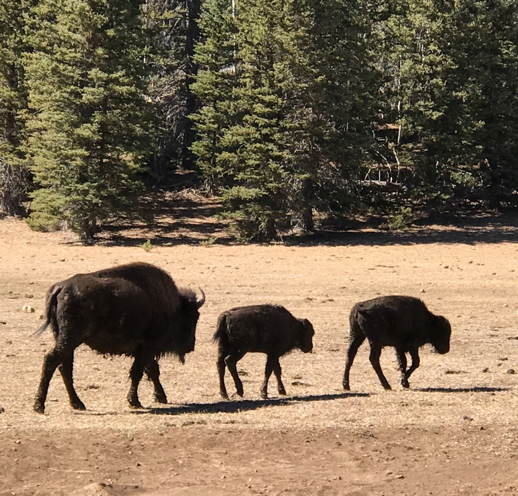
This morning we saw ~ 25 big horn sheep gathered on a rock outcropping next to the 11-mile long Walker Lake. Such sheep clusters are quite common here, as they come out of the hills and mountains for salt and other minerals concentrated near the lake. For nearly a century, farmers and the Walker Lake Paiute Tribe tried to farm the area using water from the lake. This resulted in such high saline levels in the lake that all remaining cutthroat trout died, and the lake now fails to support any life at all. A foundation exists to try to restore the lake by diverting more water sources into it, but with such meagre sources, its viability may be gone for good.
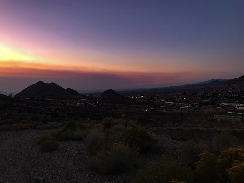
Tonopah is one of the larger towns in central Nevada and known for its 19th-century history in gold mining. In fact, abandoned mines litter a lot of the landscape out here. Gold, silver and copper mining were aggressively pursued here, with Anaconda open-pit copper mining until the 1970s. Nowadays shaft mining is the thing, but it doesn’t provide nearly as much employment as the open pit version. Nevada and Wyoming specialized in extractive industries seemingly without concern for the surrounding environments because they held little potential for tourist industry development and “nobody but the Indians and wild horses” lived out there in the desolate hills. Today the plateaus, buttes and mountains are home to ATV trails, and the wild horses remain. As do the smoke and ash clouds from California’s fires. Bluish-white haze in every valley/basin.

Tomorrow we’ll go to a national monument whose name should not surprise you, given what we explained above: Basin and Range National Monument.
———————————————————
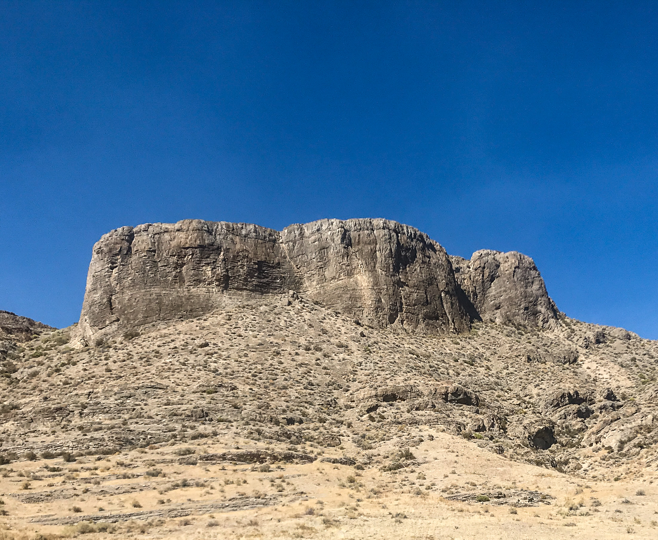
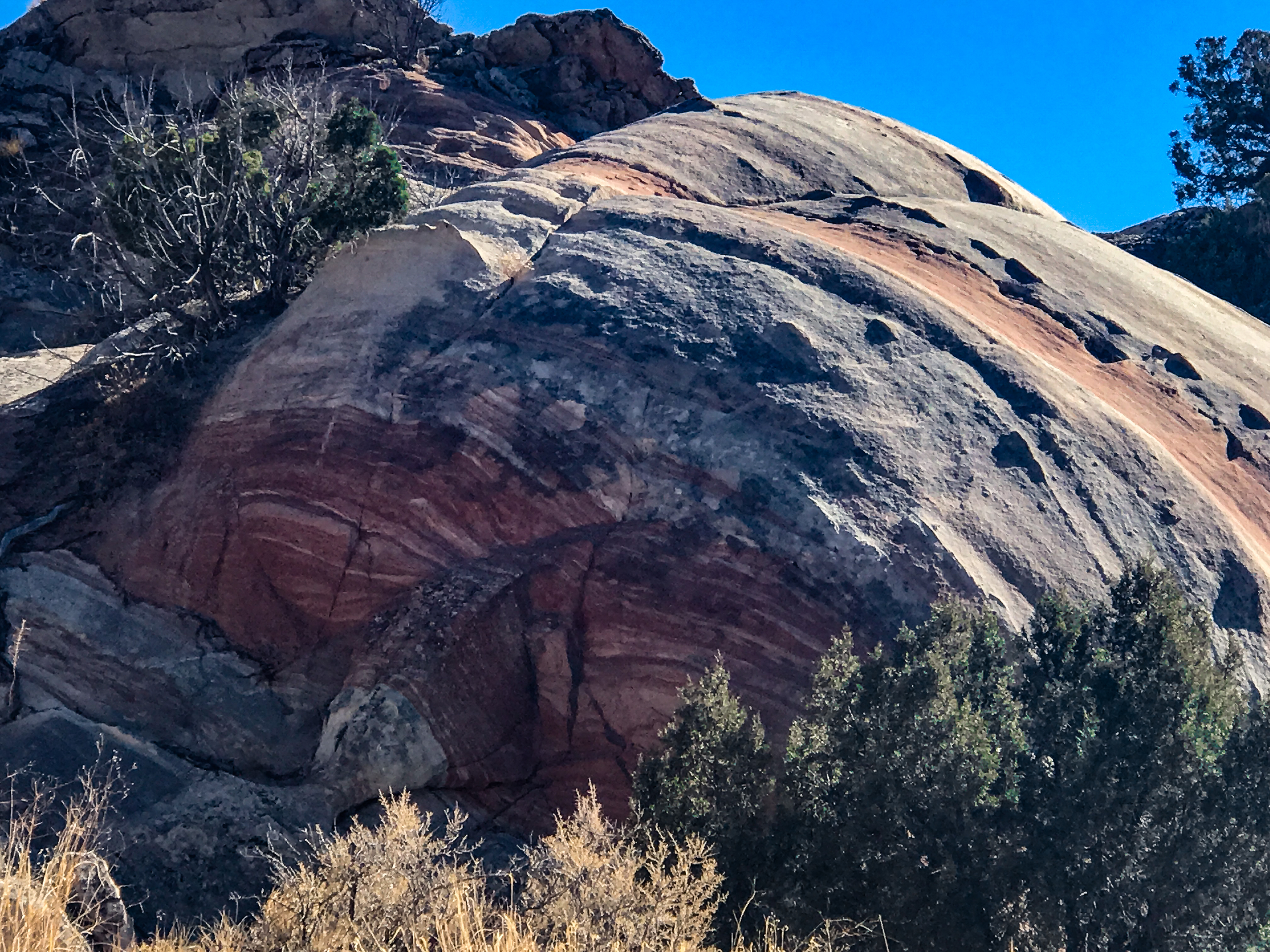
Well, today was just superb. No mishaps, slowdowns or wrong turns getting to the monument, and once inside/on the Timber Mountain Pass Trail (driving, not hiking), we saw some fantastic geology! The air humidity is 8%, so you know it’s DRY, and there is basically no vegetation on the landscape to get in between your eyes and the mountains, so we got to see every slope and speculate on the forces that made it. Great fun!
Saw a pronghorn dart out into the road and bolt down parallel to it for almost a mile before he decided to veer off over the fence. Nice buck, well-muscled and big for a pronghorn. They will generally not allow you to get closer than 300 yards, so without binoculars or a telephoto lens you don’t get much detail. But they’re beautiful.
A great dirt road allowed us to get about 20 miles into the interior of the wilderness area. So many different mountain types: cinder cones, wildly angled buttes, igneous plutons and volcanic necks, high sedimentary hills, palisades, hoodoo’s and the list goes on. Sometimes the mountains look like soft napkins that someone just gently lowered onto the landscape, other times they are very sharp or jagged.


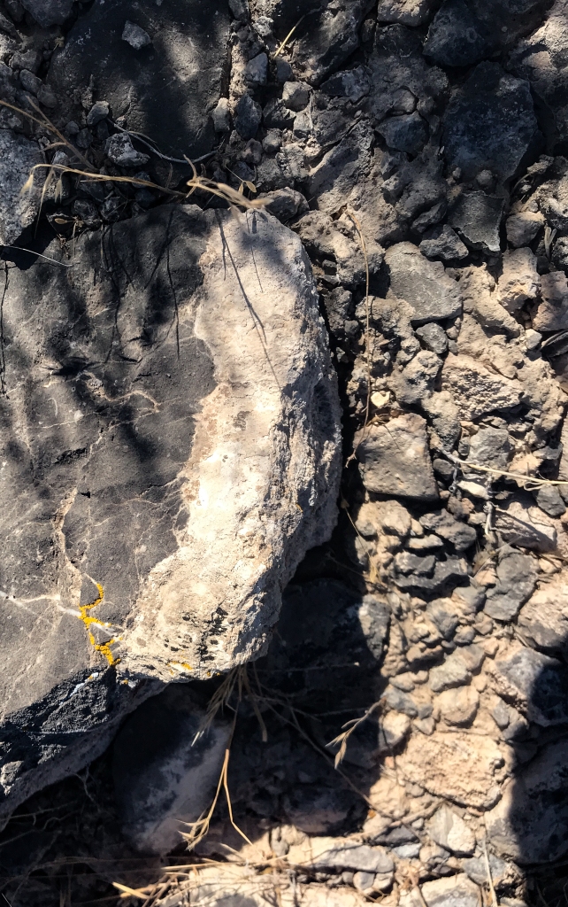
At a point called Water Gap (on the edge of the Golden Gate Range), we turned off of Timber Mountain Pass Trail onto Coal Valley Road for the return to the highway. Saw an interesting rock formation and stopped to investigate. It was mudstone with lava bombs embedded in the mud (we think!), and druzy veins that had seeped into cracks in the mud and hardened into glittery crystalline structures. Both of us have so much fun discovering what nature leaves in her wake. Never would have thought this would be a major fascination, even five years ago. Prepare to be surprised by life!!

Tomorrow we get out EARLY to beat the high-90’s heat, and discover petroglyphs left by the archaic peoples of this region.
———————————————————
OK, today was a treasure hunt. It stands to reason that the BLM doesn’t put up huge signs identifying/promoting ancient rock art in the area, because people into vandalizing and defacing this art have already wreaked havoc in many locations. But no signage whatsoever makes it a little challenging to find this art….we had a general idea of where to drive off the highway, but then could only count on the meagerest of single-pole markers (smaller than what you’d see at a trailhead) to know where to hike up to the rock walls.
No worries, we found an abundance of the sites just fine, and even where we got lost, there was lots to see.


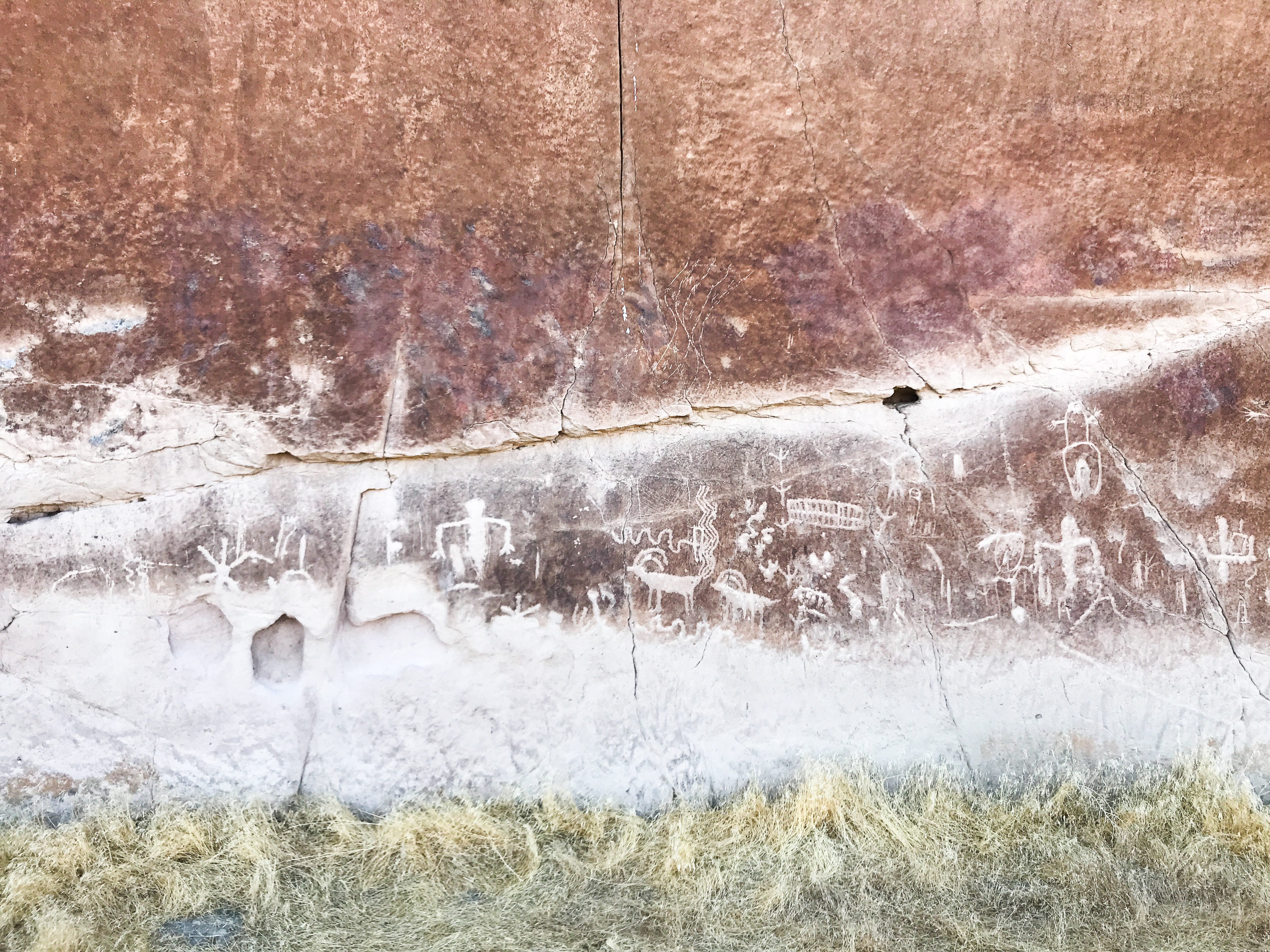
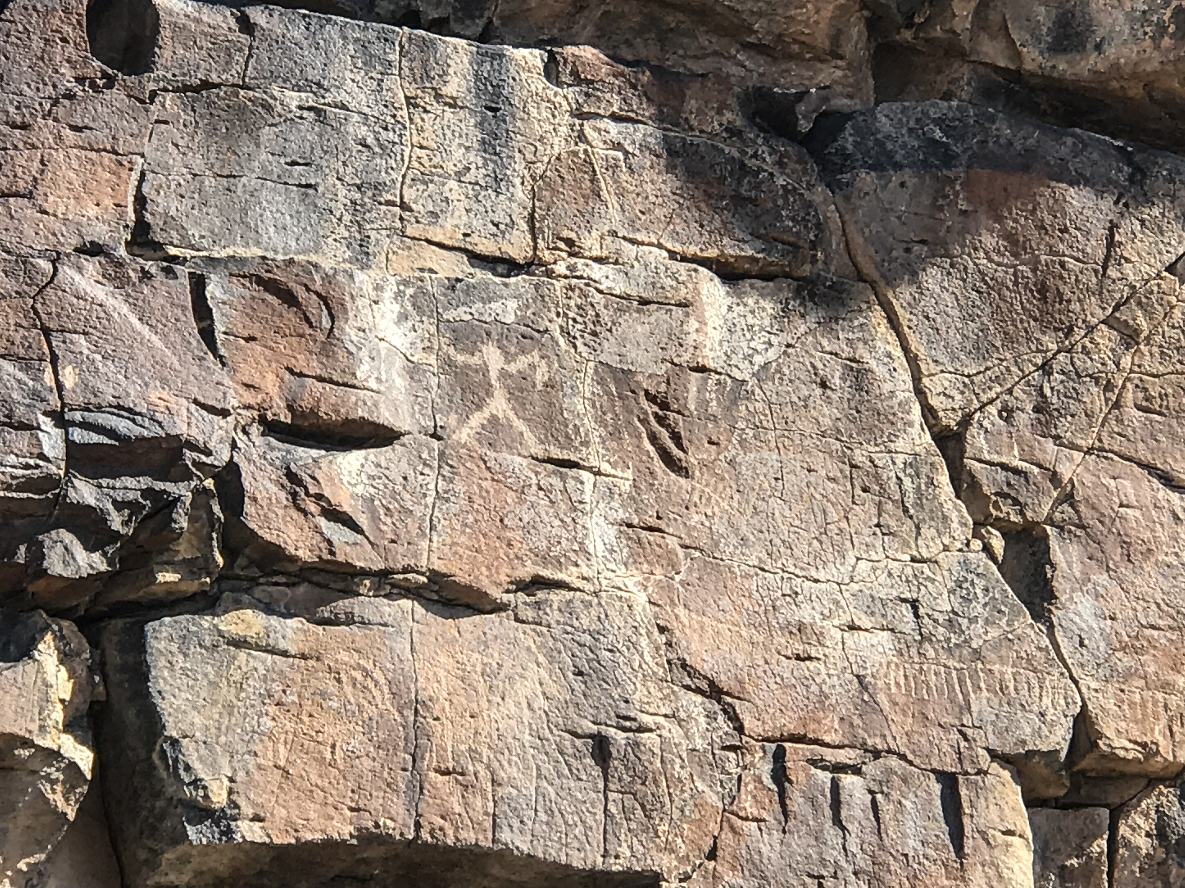
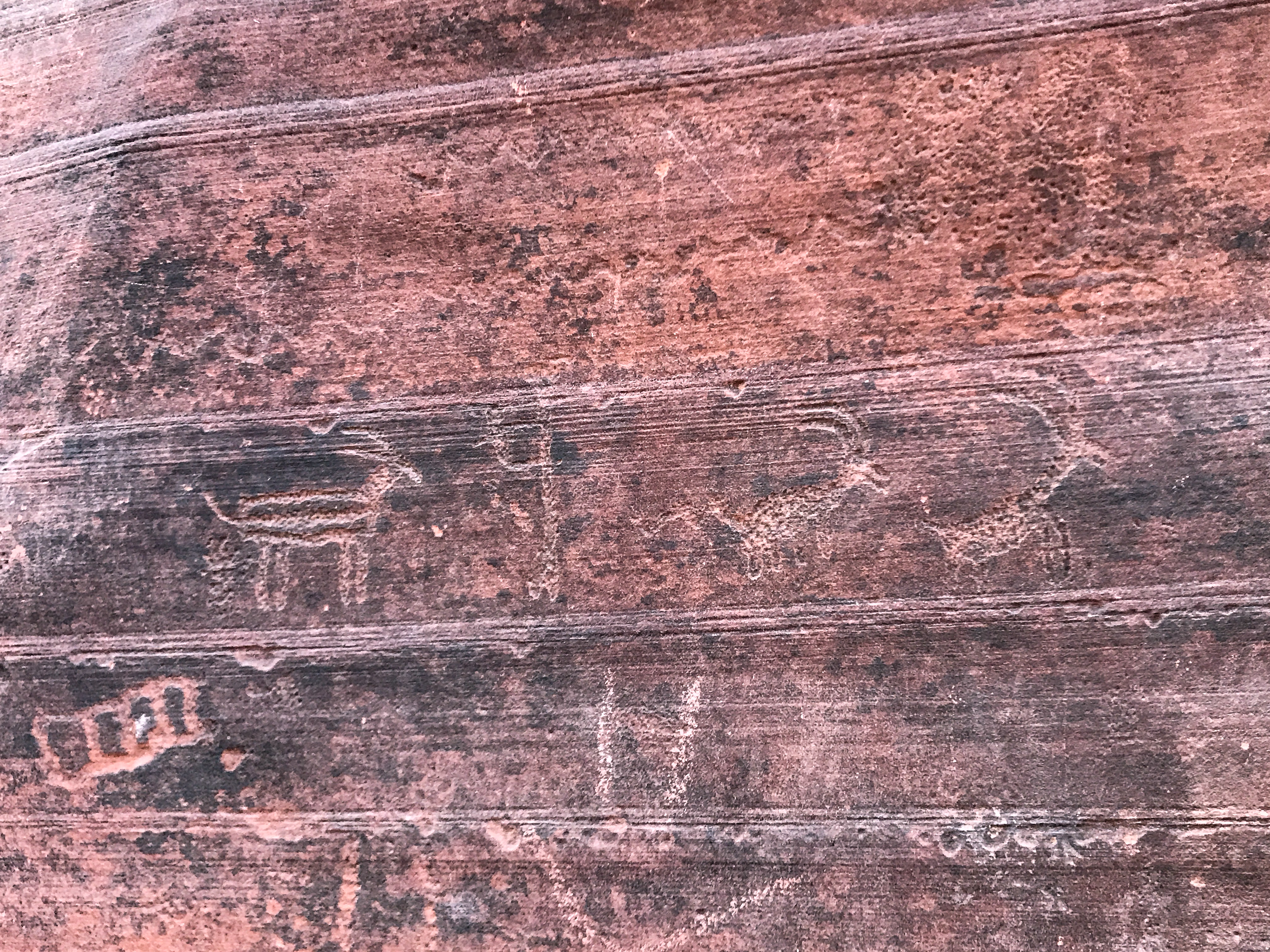
A little background: Nearly 15,000 years ago the predecessors to today’s Shoshone and Paiute tribes (the archaic Puebloan people) started pecking and incising images onto the rhyolite and tuff rock faces in the regions where they lived. Several dominant petroglyph styles took hold and are classified by the region: Great Basin (northeast NV), Fremont (western Utah and eastern NV) and Basin & Range (central-eastern NV), among others. We viewed the Basin and Range style petrographs today at six sites and were so happy to see symbolic representations of birds, big horn sheep, humans and lizards as well as abstract images of calendars, suns, energy lines and others too mysterious to name.
Starting at 7am, at 52 degrees F, we drove and hiked for four hours through the White River Narrows archaeological sector of the Basin & Range National Monument until temps rose into the 80s. The dust is so fine in this region, it’s like walking through baby powder. Then we drove back to the Mount Irish Wilderness for two more sites and lunch at 7500’ elevation on the beautiful Mount Irish slope. There are vast fields of what the ranchers call Winter Fat. It’s white sagebrush, and high in protein so the cattle grazing up here can stay alive on the range just fine over the cold, snowy months. FYI, lizards and geckos are bigger here than in Arizona!


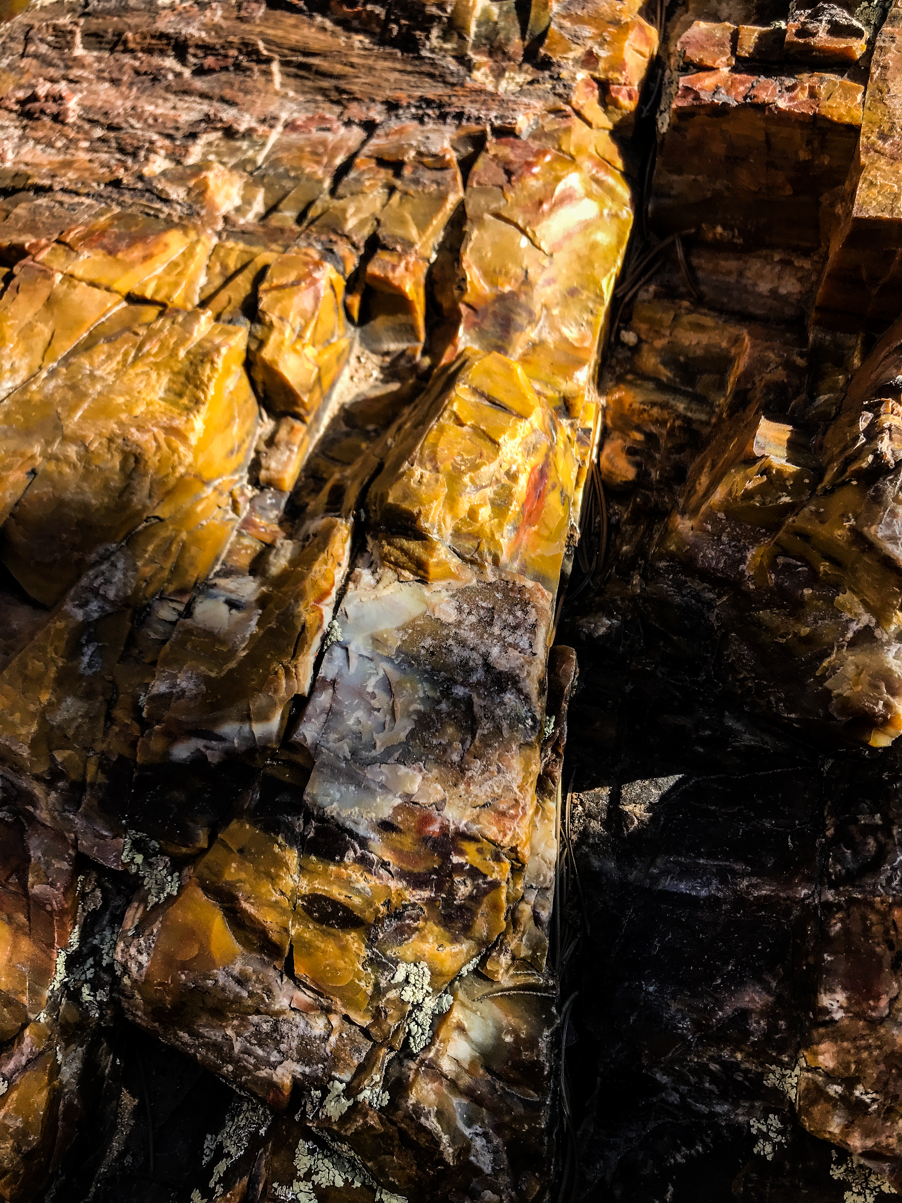
A bonus surprise on this drive. Walking around to see the petrographs, we noticed chunks of gorgeous agate-like material with sparkly surfaces ALL OVER, lying on the ground. Since this is BLM land, and not off-limits to collecting, we gathered some ochre, pink, peach and brown samples to further help in identification. Turns out, it’s a variety of onyx. So gorgeous, and we’ve never seen anything like it.
Our allergies have flared quite a bit on this trip. Seems the Rabbit Brush blooms (yellow) at this time of year, and it’s about as prevalent as the sagebrush. And then there’s the dust and the fire smoke which still hang in the air.

Temps at our lunchtime pullout were 10 degrees lower than in the basin below. A stiff breeze made it feel like low 70s – perfect. From there we could see three mountain ranges and two basins lined up in succession. This is what we came for!!
Tomorrow we are off to southern NV, to the Valley of Fire State Park. Can’t wait!!
———————————————————-
Driving across the SE NV desert this morning, we see the first barrel cacti of the trip. Feels like we’re back in the Sonoran landscape of AZ. On one side of the road, signs identify the region as critically endangered wildlife environment, on the other side someone has built a huge, water-sucking golf resort. Wow. People are such a disappointment.
We’d planned to dry-camp (aka boondock, camp out in the wild with no electricity or water supply) near Valley of Fire SP. But temps are soaring today. We tried to muckle through at a nice clean plateau called Poverty Flats, renowned as a great boondock site near the State Park. Lots of other campers already there when we arrived. Set up on the edge of the mesa, we actually got a little updraft from the canyon below. But when it hit 100 degrees with no shade (and my sinus headache decided to scream), we checked out the available sites in the State Park instead and opted for one with both electricity and water. So very glad we did. Heat topped out at 103 degrees F.


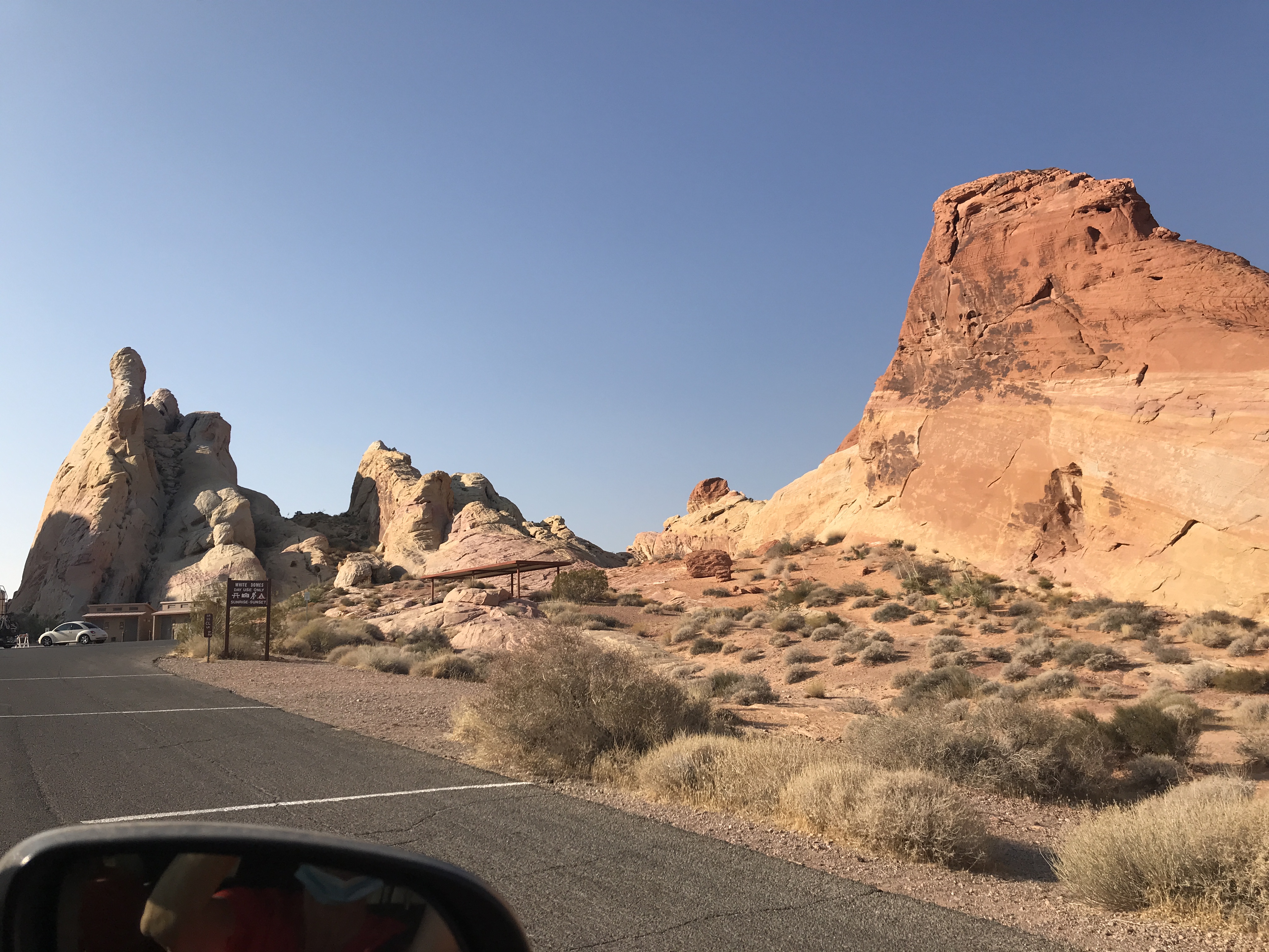
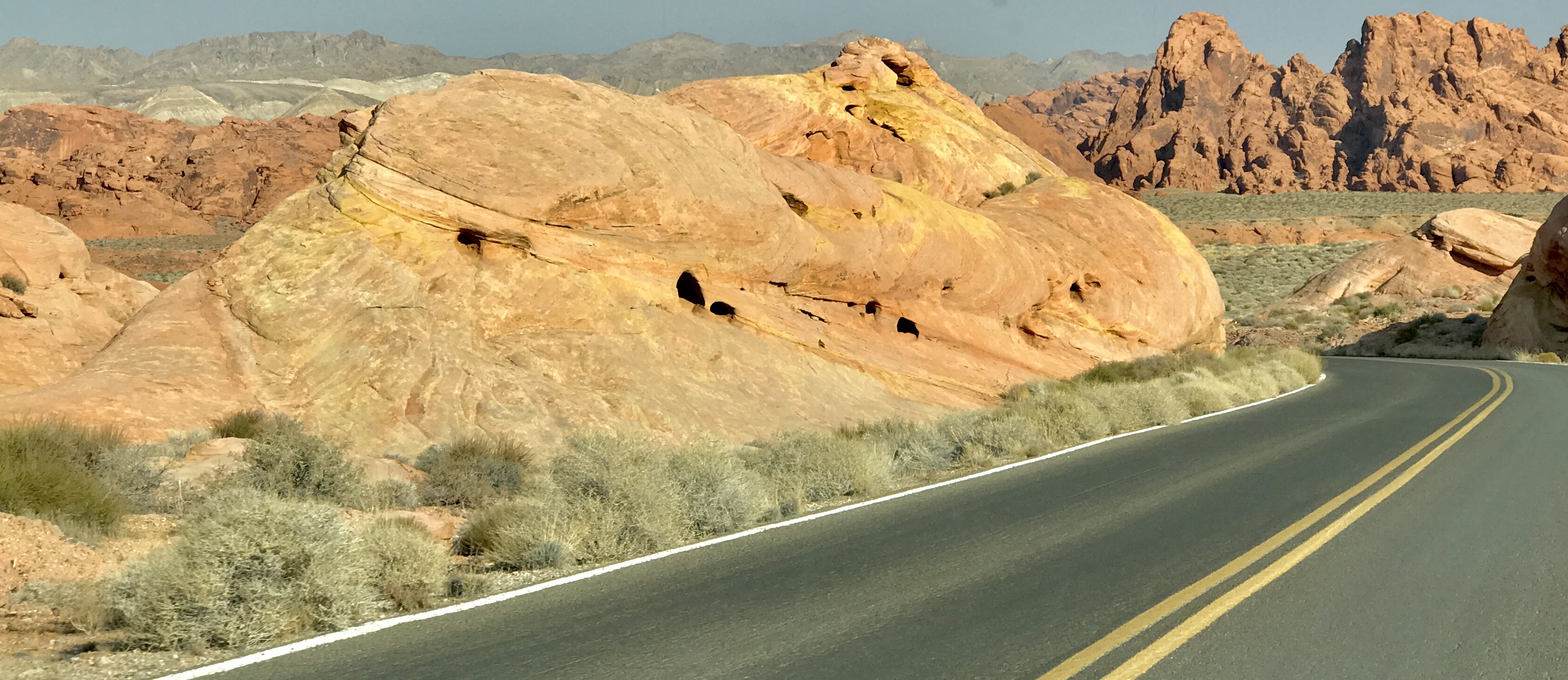
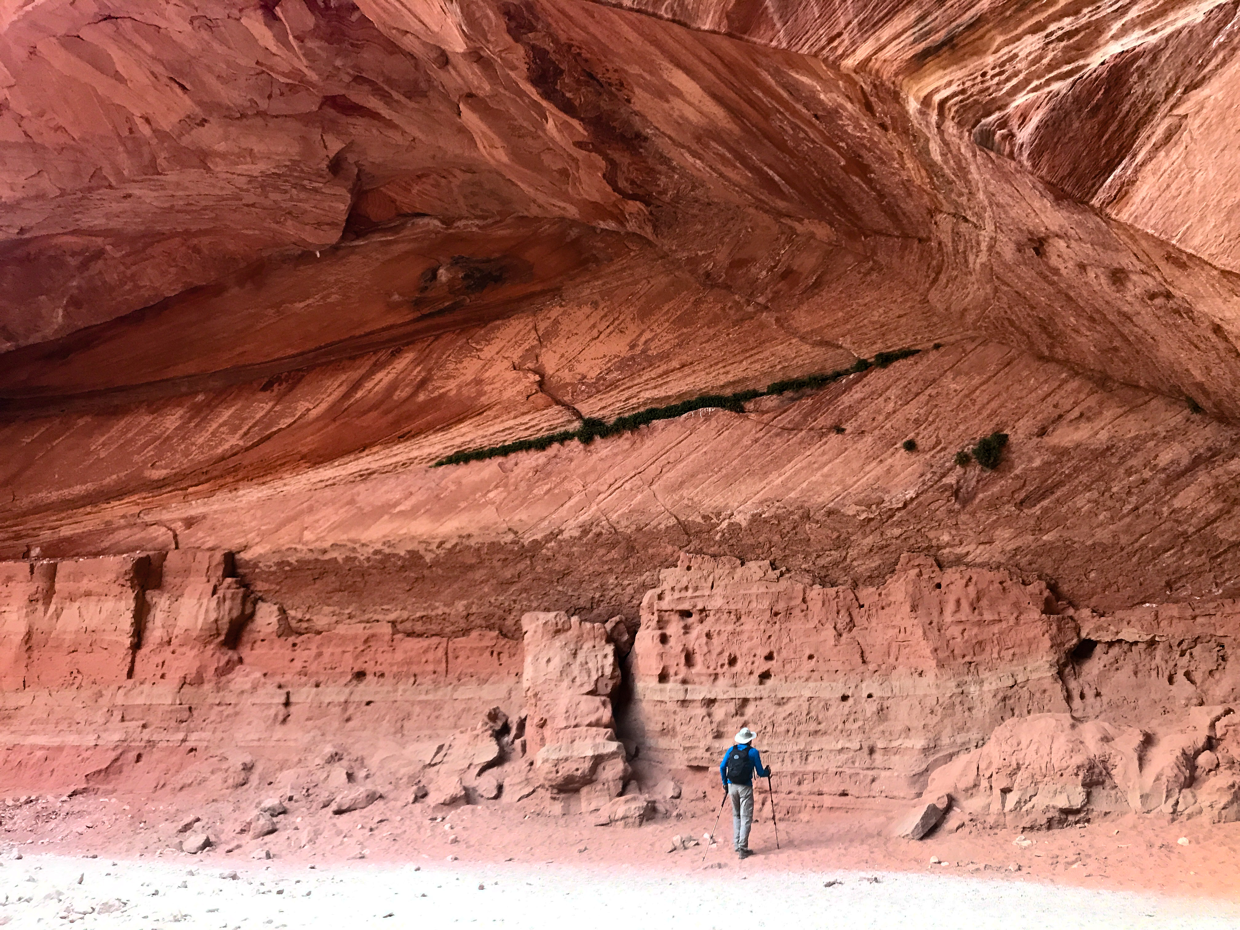
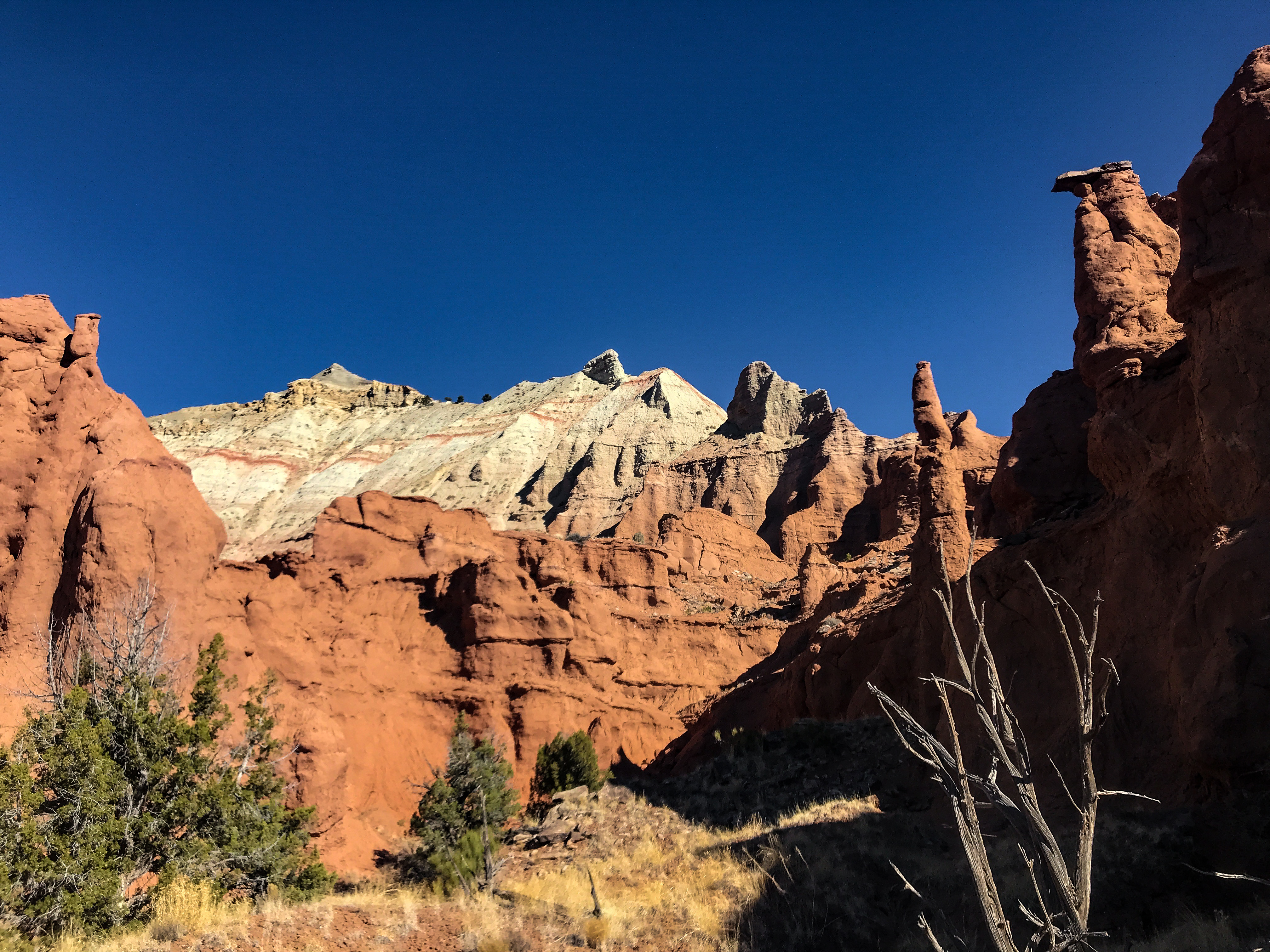
Driving through VoF State Park was like a homecoming, as we’d been here first two years ago and loved it. The mountainous terrain is a dark buff-grey where the oldest limestone and dolomite rocks are (south side), but the rest of the slopes are a deep, warm red sandstone with occasional white sandstone structures mixed in. These rocks are between 60 and 600 million years old, from a time when the ocean covered the landscape. Since the water drained away, over 10,000 feet of sandstone depth has been worn away by wind erosion.


One scientist has described the scene as fossilized sand dunes, and that is pretty accurate – assuming the dunes were once as high as a plane in ascent! Now they are 100 – 150 feet high, with wave-like textures in the rocks and colors blending to look like dark butterscotch taffy and rainbows ranging from ivory to peach to terracotta to purple. Pockmarks, arches, caverns, hollows and strange body-part looking protuberances abound.
For children, this park is a vast Adventureland, as there are wide runways for them to race up and down, and the sandstone provides great traction. Saw two bighorn sheep ewes on the way back to the campsite tonight. We will see a number of the rock features tomorrow up close, as we’ll be hitting the trail just after dawn to beat the heat.
—————————————————————-
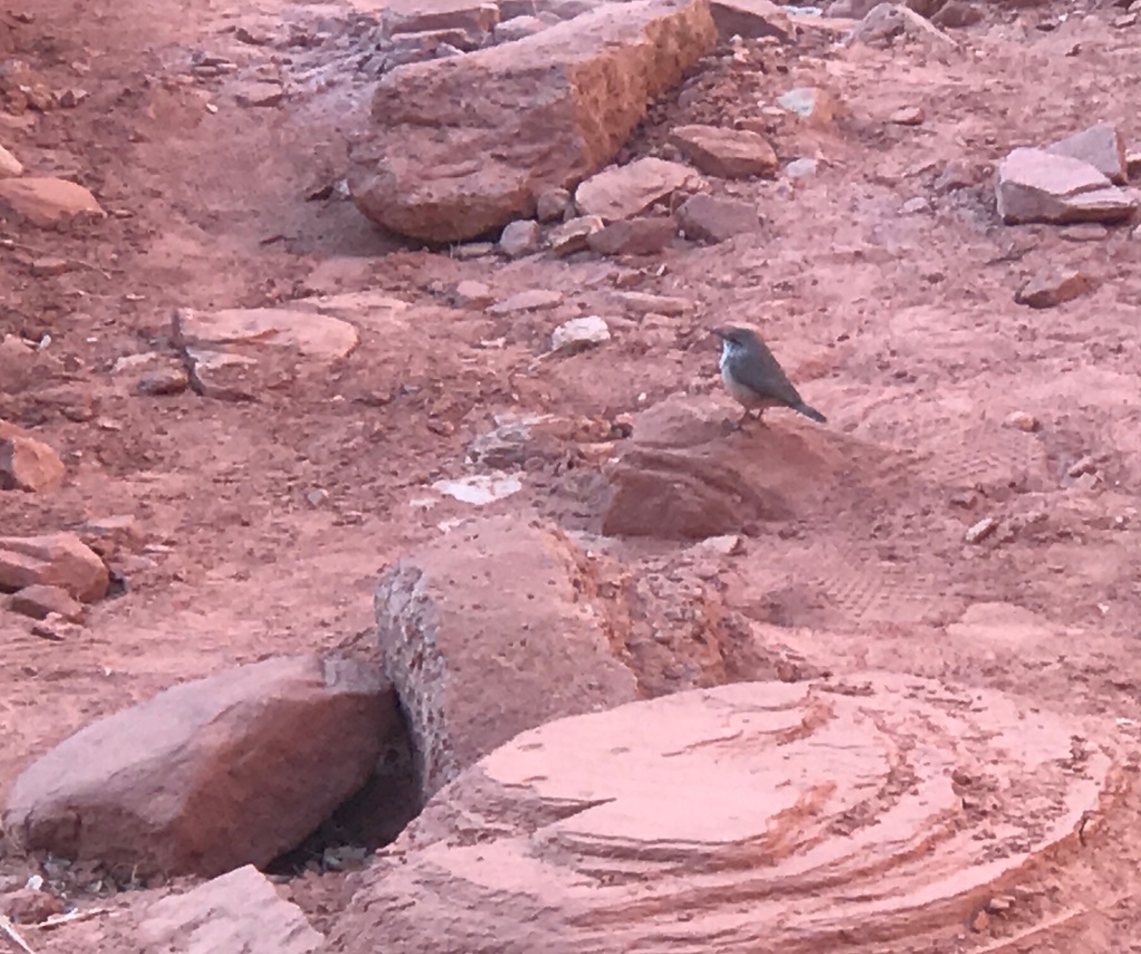
Up with the sun today, it’s 62 degrees as we lace up the boots. First up is a short trail called Mouse’s Tank, for a 19thcentury robber who it seems liked to hide out among the rocks here, where two deep crevasses trapped spring rainwater just like an open cistern. The path to these crevasses (or “tanks”) is a labyrinth of twisted and towering figures of sandstone, beautiful to behold and in an entrancing combination of colors. We were all about the colors on the way to the tanks (and the 20-member bighorn sheep herd we saw close-up on the rocks!), and on the way back, all about the petroglyphs, of which there were many. This trail has much to offer in a mile RT. But the winds have changed today, and the fire smoke and ash has now obscured the distant mountains. Visibility is noticeably down.


Next up, Rainbow Vista. By this time (7:45am) the temp was up to 75 and sun was fully ablaze on portions of the walk. The landscape was lovely, but the experience was marred by the fact that there was diminishing shade and some uncertainly about how far away the actual rainbow vista was. As we have found in the past, some parks just don’t provide full information about distances to their points of interest. We did eventually discover that there was a Fire Canyon lookout at the end of the 1-mile trail, but its best visual glories are probably peak at sunset, not at or around sunrise. Happy, regardless, that it’s not yet broiling hot! And on the way back to the car, we decided that the so-called Rainbow Vista was actually less than ¼ mile from the lot.
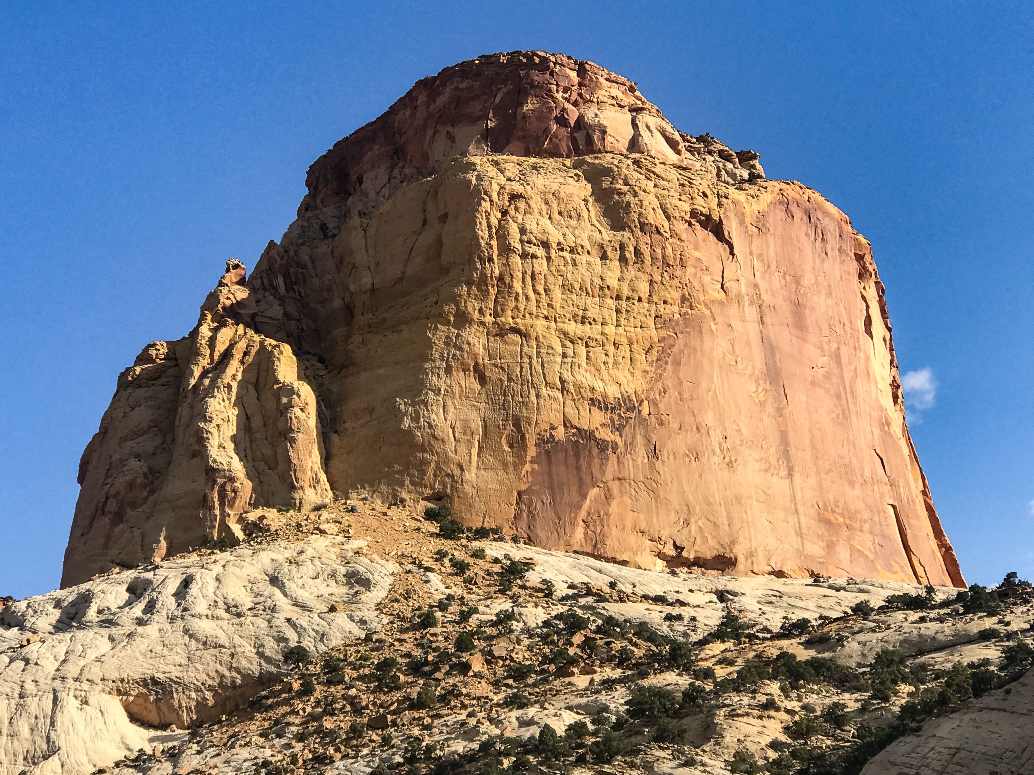
Our final trek of the day was really not a hike, but a drive/walk to White Dome at the far end of White Dome Drive. I think we did all of a quarter mile and saw an amazing lookout onto a chalky drip castle-like wonderland. Colors on display ranged from ivory to terracotta to deep rose to milky violet to black. Superb. Wish it had been sunrise again instead of being in the high 80s. So much for dry heat being better!! We saw another grouping of sheep on a precarious slope (their favorite terrain), a couple of lone ram teenagers along the road, and a ram licking salt in our campground on our final morning. The animals all look in great shape. Also ran up a short hill before departing to see an agatized petrified log.


This is just a spectacular park. Great scale, immaculately clean, very doable in two days, full of wildlife (if you slow down and take the time to look for them in the early morning/evening), and a great diversity of landforms over the span of the park. Perfect park for families, as there are so many rocks and hidey-holes for kids to scramble into. We loved it and will be back.


————————————————————
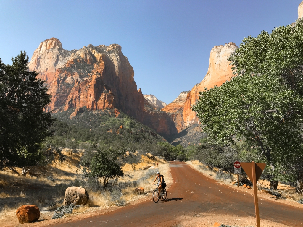
Today was our reconnaissance day for Zion National Park. Lots of surprises. Cannot do the final stint of Angel’s Landing () hike because of COVID, nor The Narrows because of toxic cyanobacteria in the river water, nor Observation Point (landslides from 2019, still not cleared). Also, due to concerns over crowding, there is a complicated system for getting reservations for the park shuttle, needed if we want to get up into the main canyon. But they only open the lines for reservations after 9am each day…after we will have been on the trails for three hours. How does that work?
We were able to drive along the Zion-Mount Carmel Highway (east-west throughway) in our own car, along with great numbers of other Sunday afternoon drivers, and it was a fabulous introduction to the monumental sandstone rock architecture in this park. Quite similar to the Going to the Sun Highway in Glacier NP for breathtaking, soaring landscapes and long vistas. We’ll go back there tomorrow near dawn to hike the Canyon Overlook and Watchman Trails. Later in the week we’ll tackle East Rim, a 12-miler. But for the rest of the time, we’ve decided to run up to the Kolob Canyon/Western sections of the park. Far less swamped with tourists/hikers and rumored to be as beautiful as the southern end of the park. Thousands of visitors are where the most storied sites are — it’s just too much for us in a week when it seems all of Washington DC has caught COVID.


Surprise!! Today we secured a shuttle reservation for 7AM down the main Canyon Scenic Drive, so tomorrow we will be doing the first 4 miles of Angels Landing + West Rim. YAY!!!
We hiked the Canyon Overlook Trail first today, a one-mile hike but such great views. It lives up to its ratings, the only detracting point being that it was already packed with hikers at 8am, most of whom were not masked.


The drive to Watchman Trail was like a reverse commute: pretty open and uncongested. Once on Watchman, we were happy to be in the shadows for nearly the whole out and back. It’s rated as moderate, but at only 4.4 miles round trip, it was really a piece of cake. The path is fairly wide and very secure, and the summit has a nice additional loop trail that gets hikers as close as possible to an unobstructed view all the way down the entrance canyon of the park. Spectacular at 4500’ elevation. The hike was uncrowded on the way up (9:15-10:15), more congested on the down (10:15-11:00). We would not recommend starting this trail after 9:30am for anyone not wanting to wear a mask non-stop and continually squeeze to the side to let others pass for the entire distance.
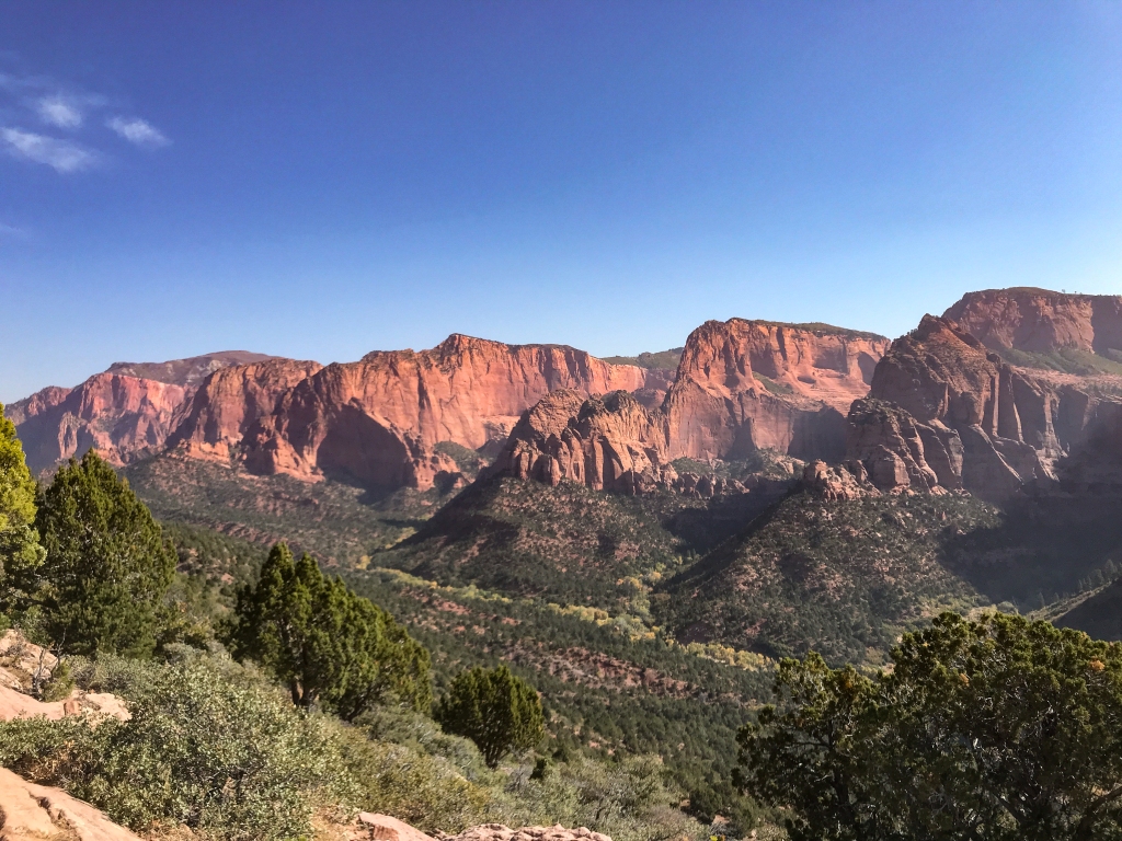
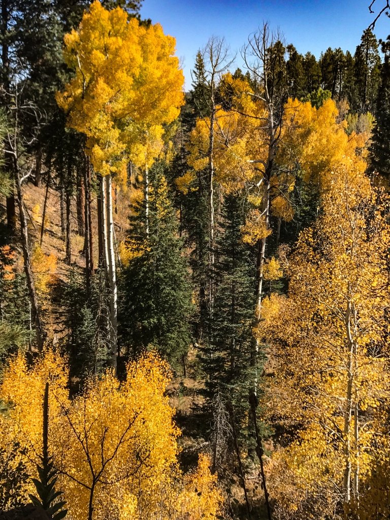
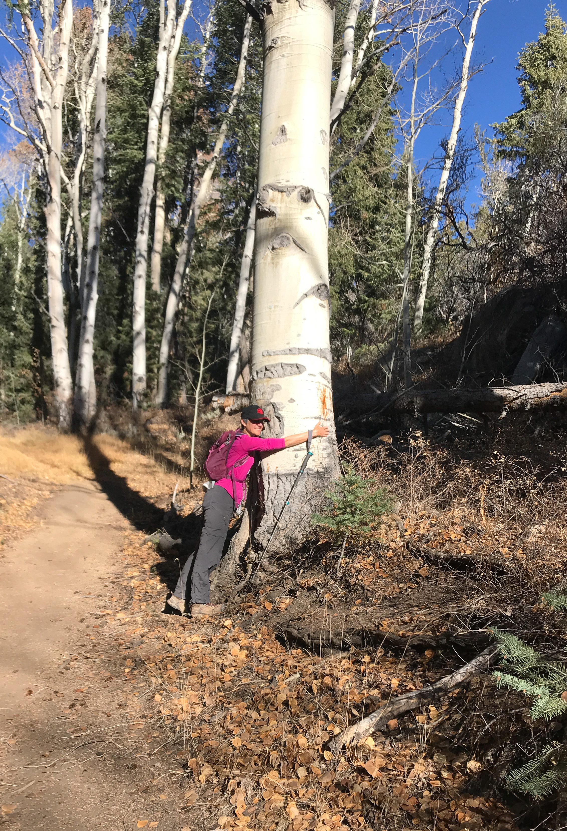
We’d been entertaining the idea of just going to the western area of the park, known as Kolob Terrace/Kolob Canyon, to escape the crowds. Did recon in the Terrace this afternoon to test the plan. Terrace is VERY different from Zion, few dramatically high slopes and the smoke/smog/haze obscures views of distant peaks. So, a complete switch from one to the other side of the park would be a big sacrifice after all. But we will do one hike over there because so many of our targeted hikes in Zion have been scrubbed. This drive allowed us to see the Quaking Aspens and Sugar Maples in full fall color. Magnificent.


—————————————————-
Today, to our great surprise, Angels Landing Trail is OPEN. So, we took the scheduled shuttle (with 50 other eager hikers, all masked) to the Grotto bus stop in the main valley and began the ascent at 7:30am. Temps were great (59 F, wind, trail in shadows) and we made it to the top (2.25 miles) in an hour, including the 21 switchbacks known as Walters’ Wiggles.
I decided to attempt Angels Landing, got ¼ of the way and then turned back. Too many people, too much wind, and I knew George was very nervous with me up there. This is not a hiking style to adopt later in life, although we have done a few chain-assisted hikes (called via Ferrata in Europe), but with so many amateur hikers up there, it just was not optimal. Many people were pursuing it as a stunt/dare…not my thing.


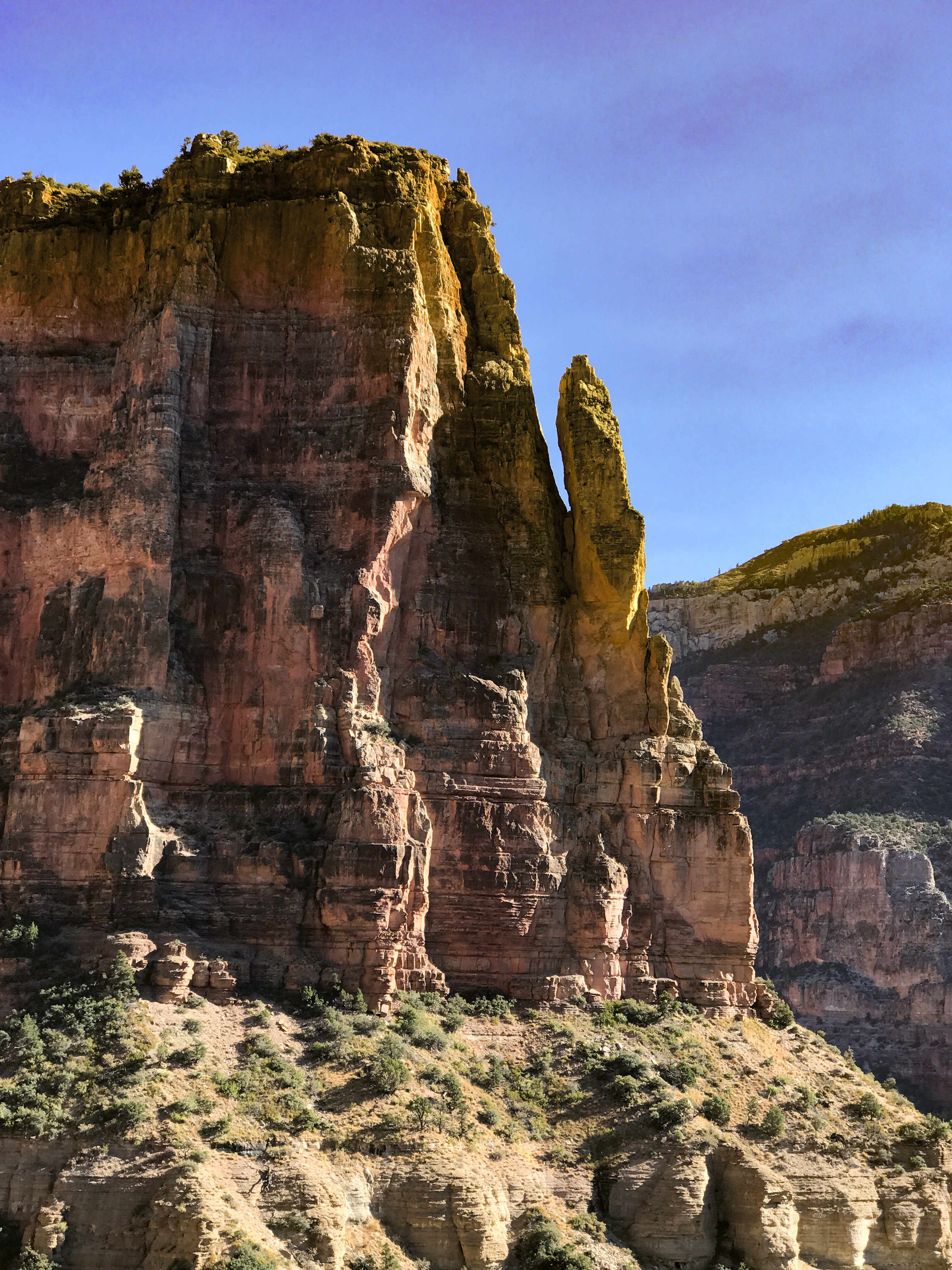
The continuation of this hike was the best part of the day. It’s called West Rim, and it’s glorious. We went halfway to Cabin Springs, which made our total hike about seven miles with 2,000 feet of elevation gain. The scenery is out of this world. For a geology nerd like me, it is like being a kid in a candy store. Most of the visible rock is Triassic or Jurassic sandstone, some Carmel limestone, some mudstone and a bit of basalt lava. Lots of faulting, arch and slab erosion, rock staining from pour-over drainage, and beautiful exposed layers. Our route followed canyon walls cut by the Virgin River, and we tried to imagine how this slow-moving (at this time of year!) flow of water can move 300 million tons of sandstone particles every year. Suffice to say that Virgin River rushes in torrents in the spring and early summer, and a lot of the rock here is quite soft, eroding just with the wind currents.
We found a semi-secret spot on the rim that affords knockout views of the end of the main canyon, and what do you know? We saw condors!!!! Largest raptor bird in the Americas! Huge, and making a comeback in the Sierras and on the Colorado Plateau. We feel very lucky to have seen and heard them.


After the descent in full sun, we were pretty knackered. Rode the shuttle down to the end of the canyon to see the Temple of Sinawava rock walls, and on the way out of the valley caught sight of mountaineers climbing a sheer vertical surface 3,000 feet high. Plenty of those for them, as long as they register with the rangers.
Zion National Park is awe-inspiring but has become another national park where you can hardly admire the nature and love the silence because there are so many people coming, going and hanging out. 4.6 million visitors per year. Now more popular than Yellowstone and Yosemite. If you don’t get to the parking lot at the visitors’ center by 9am, forget it. This is crazy. Spread out, people. There is lots to see in the North American continent!!
—————————————————————-
Today was supposed to be a low-key, low-mileage hiking day. But we managed to rake up eight miles to see all the beauty on two trails in Kolob Canyon.
First up was Taylor Creek Trail, a lovely 6.9-mile creek-side hike. All told, it has 114 creek fords (57 out, 57 back), but with water so low at this time of year, they’re no big deal to cross. We followed the canyon all the way back to Taylor’s main attraction, a spectacular double-arch alcove wall. Classic Zion sandstone architecture all the way. This canyon was cut by the La Verkin river and the rubble around and in the water suggests that there are many mudstone layers in the surrounding mountains.


From there we drove along Kolob Canyon and then hiked the 1-mile Timber Creek Overlook Trail at the road’s end. On this easy path, visitors can see a splendid range of mountains to the east, encompassing Horse Ranch Mountain (highest point in the park), Paria Point, Beatty Point, Nagunt Mesa, Timber Top Mountain, and Shuntavi Butte. Many beautiful hanging valleys, interesting erosions, standing towers, and evidence of both slab and spire falls to the valley below. The Pine Mountains to the west are lovely, as well. Pinyon Pines and western juniper are in great abundance up here.

—————————————————————-
Such a blissful 11-mile hike today!! As our last trail in Zion, we hiked the East Rim at the edge of the park, it was absolutely wonderful and very lightly trafficked.
First, the scenery along the Zion Mt. Carmel Highway is stunning, and very desert-like in terms of aridity and minimal vegetation. The towering, sweeping, curving sandstone shapes are magnificent, and they carry over into the East Rim trail. The entire way is actually very easy to stroll through, except for the pillowtop sand sections where hikers have broken through the crust and it’s then 3” of mashed potatoes to slog through.
We saw a beautiful Peregrine falcon flying low through the canyon, which was a great thrill. Many pairs of Stellar’s Jays, which are gorgeous with their iridescent bluebird backs, and woodpeckers/sapsuckers. Lots of birds on this trail, probably because it’s not too populated. Only encountered 35 hikers over 11 miles – my kind of trail!!


I am calling this route the Ombré Trail, because of the prevalence of colors fading from white to peach, or ochre to red, or anything in between. Love-love-love the gradation effect.


There is spellbinding scenery for the first 4 miles of East Rim, and then you hit Jolley Gulch. What can I say, it’s a roller-coaster of a canyon, mostly buff and putty-colored in the narrow end, but the clincher is the 100’ vertical drop at the end where hikers and mountaineers obviously rappel down into a deep hole. Difficult to describe, butterflies in the stomach if you look directly down into it, and then looking out, you see the ombré rainbow on the rocks again. Magical. Someone has even left rappelling straps to hook your ropes to for those who are ready to try.
The rest of the hike (for our 5.5 miles out, 5.5 miles back) is along the top of the mesa, in a forest of beautiful Ponderosa pines. Not really much of a long view, but on a warm day we were very glad for the shade the trees provided. The trail goes all the way to the Weeping Rock in the Main Canyon, but that would have been a total of 20 miles round trip, and we sure didn’t have it in us today. Altogether we’ve hiked 26 miles in Zion over four days. Outta here in the morning, which is fine by us – Zion is simply too crowded for us this season, and probably in any season except for winter.


——————————————————
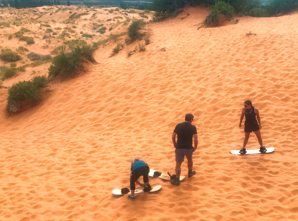
After an hour’s drive to Kanab, UT, we settled in, had lunch and then drove north to the Coral Pink Sands State Park just southeast of Zion. Thousands of acres of what I’d call coral peach-colored sand dunes, likely blown there from the Grand Canyon, are now home to ORVs and Sand-surfers by the hundreds. It is a lovely sight and it seems the ORVs are not driving over native plants anchoring the sand in the dunes, so all is probably ok.


One of the park rangers approached all visiting cars with a pet gopher snake twined around her arm. They’re harmless, and we petted the snake as encouraged by the ranger to do. Snakes are very beneficial to the environment, and so many people are creeped out by them. That’s a loss for humans and snakes.

By mid-afternoon the sky was nicely overcast so we drove to the Utah Dinosaur Tracks site (north of Kanab) for a climb up the sandstone to view the toeprints. Wow, that was a fairly difficult and treacherous climb. The elevation was only 250 feet but at points it was nearly vertical upward. Weird that the tourism bureau of Utah promotes this paleontology attraction, but there is virtually no engineered trail up the slope. Scramble all the way.
Also, the site is not protected by signage or warnings not to take artifacts, therefore treasure hunters appear to have made off with a fair number of track casts. We found only four clearly identifiable toe prints, but the promo material claims there were nearly 200. Hunh. All’s well that ends well, beautiful view from up on the mesa and we have a story with pix to share with the grandkids. And we saw a Merlin falcon up there, hunting. So fun to see these raptors in their glory.


——————————————————-
A perfectly wonderful day in southeast Utah! The point in coming to Kanab was to seek out a couple of slot canyons and see what the buzz is about, so we started the search at 8:30am today, at the Red Canyon/Peekaboo Slot Canyon, after a wild, spine-shaking ride down two miles of washboard sugar-sand dune buggy path. Saw a streaking coyote cross the road on the way!
Red Canyon is a very short (1/4 mile) slot canyon, but it’s a red and orange marvel and especially splendid in the early morning light. Lovely rounded walls, perhaps 75’ tall, very sensuous shapes inside. The days are getting shorter very quickly, sunrise is now at 7:40, and we’re getting crowded into very small windows of time when the sun is up but the day is not too hot for hiking!


Thereafter we drove into Kanab for French pastries (tomorrow’s breakfast) and then out to a set of trails the city/county has developed for tourists staying in town.

Really nice canyon walks, but we could only get in 2 miles before the heat chased us back to the moho for an early lunch. Did get to see a cheeky blue-grey gnatcatcher in the canyon. Little flirt has learned to beg for food.

Once revived, we set out for a preview of tomorrow’s hike up Wire Pass/Buckskin Gulch. This is a set of slot canyons that are reputed to be unmatched by any others. The world has now discovered the “best” ones, thanks to Instagram, and this pair of canyons is so popular that there were 50 cars at the trailhead (full parking lot with 50+ cars) when we arrived! For sure, we are getting there at dawn tomorrow to beat the crowd.
The scenery along Highway 89 close to the Arizona state line is breathtaking! I’m so glad we get to see it again tomorrow. The run over to Paria Canyon (east of Kanab, just on the edge of Grand Staircase Escalante and Vermillion Cliffs Monuments) displays eye-popping, striated sandstone walls, canyons, mountains and washes in all possible colors. We also noted many cinder cone-like formations, which we believe to be clay-sand sediments that have eroded and blown over the mountains to be dropped into perfect cone shapes. Think of the way snow drifts after it has been slowed down by an obstacle in its way. Just so with the clay-sand mix, and it’s heavy enough to remain where it fell, out of the main flow of wind. So fascinating!
——————————————————-
Some days are full of learnings.
We headed back to Paria Canyon at 6:10am to beat the crowds, and 16 cars were there already! The secret’s out here for early hikes on the weekends. No problem, though, we didn’t run into anyone until we had turned around to head back.
Started out on the easy Wire Pass Trail, which follows the broad wash from the parking lot to the point where Wire Pass merges with Buckskin Gulch. The colorful red Kayenta Sandstone, interlayered with whitish-grey mudstone in places, followed us all the way to the point where the slot canyon began. With walls now 200’ high, the color faded to browns and charcoals! It was way too early for the sun to beam down into the canyon, but also, in this area it seems like water flowing down the walls and desert varnish compete to layer on as much black as possible. The result was a very different experience from yesterday.


As the pictures reveal, Wire Pass Slot Canyon’s walls are VERY close together, in some places they are shoulder width at most. You could imagine that this is a very spooky place at dusk. Dark recesses, little reflected light, and subdued colors on the walls. Interesting, but not nearly as WOW as yesterday.
There is one 8-foot dry fall at the midpoint of Wire Pass, and someone has very generously installed a well-constructed wooden ladder for hikers to use in place of ropes. Most hikers would have a tough time scrambling down an 8-foot vertical drop.
We came to the confluence point where Wire Pass and Buckskin Gulch meet and discovered the largest sandstone arch we’ve seen to date. It’s not hollow, but it is impressive, and light filled. Inside the arch are dozens of handprints in the walls, made by Ancestral Puebloans when the sandstone-mud walls were still soft enough to hold imprints. Next to them are several series of petroglyphs showing bighorn sheep, deer and spiritual symbols.
We initially entered Buckskin Gulch in the south (right-side) slot, but only went a short distance before turning around and heading into the north slot. Really, both sides are pretty much the same, but the north side has fewer boulders obstructing the path. The walls are even higher, up to 500’ in some places, again not much light gets in, and the walls are very stained with black desert varnish and/or mold/lichen residue. Surfaces are rough, angular and appear notched — not at all like the sinuous surfaces of yesterday’s Red Slot Canyon. We only hiked about a mile of the 21-mile Buckskin Gulch. Most of what we saw in the initial 200 feet looks like the rest of the canyon section we hiked.
Doing these canyons has made us realize that perhaps we’re not slot canyon people. It’s much like subterranean cave-spelunking, without the bats and spiders. We’re sure that each slot canyon has its charms, it’s just not what we crave. Good to have figured that out.
As a final workout, we drove to the nearly adjacent White House Trail to the east of Paria Canyon. What a different experience! Back to sinuous walls, but these were almost all white-grey mudstone/sandstone, with the canyon very broad indeed (1/3 mile between the high sides). As directed by the BLM, we hiked down the wash and what fun it was!!!! This canyon and the residual wash were cut by the alkaline Paria River. Nothing drinks the water, and it’s probably not great for living, growing things. But it is GREAT for rock tumbling, and we saw some of the most beautiful high-gloss river rocks ever. Chalcedony, chert, flint, basalt, quartz – anything that will hold a shine was ground down and polished by the river to a sparkly finish. Of course, as luck would have it, the shiniest rocks were solidly embedded in the bottom muck and since the river is completely dry this time of year, you’d have to chisel them out!! We got a few small, select (non-embedded!) samples to share with our rock-loving grandkids, and the rest are in our memories.


Thereafter we headed to an outlook for lunch and then home to the moho. Tomorrow, the north rim of the Grand Canyon!!!
———————————————————
It was nice to have only a 45-minute drive from Kanab, UT to our campground north of the Grand Canyon North Rim in Arizona today. The bad news? Every day we hike here, we’ll have an hour’s drive to get to the trailheads! The park service has shut down its North Rim campground inside the park because they are replacing the water pump that serves the entire south and north rim, and it’s a L-O-N-G drive from the last private campground outside the park to the Rim trailheads. The other bad news? Even with these limitations, there are STILL way too many (unmasked) people at the park by midday
We did our usual reconnaissance to check out options for hiking, and over the next three days we now plan to do 1) North Kaibab to Rushing Springs (10 miles RT), 2) the westward Widforss Trail (9 miles), and 3) a combo of Uncle Jim’s Trail, Cape Final and Cape Royal (~11 miles) going east. We’ll see if we can pull off everything in three long days, but the temps are great at 8800’ and we think we can do it!!
Some gorgeous drives through the forested sections of North Rim, showing the brilliantly golden-orange Quaking Aspen trees against the Ponderosa Pines. The small fry Aspens are coming in nicely where the 2019 fire scorched a large swath inside the park.
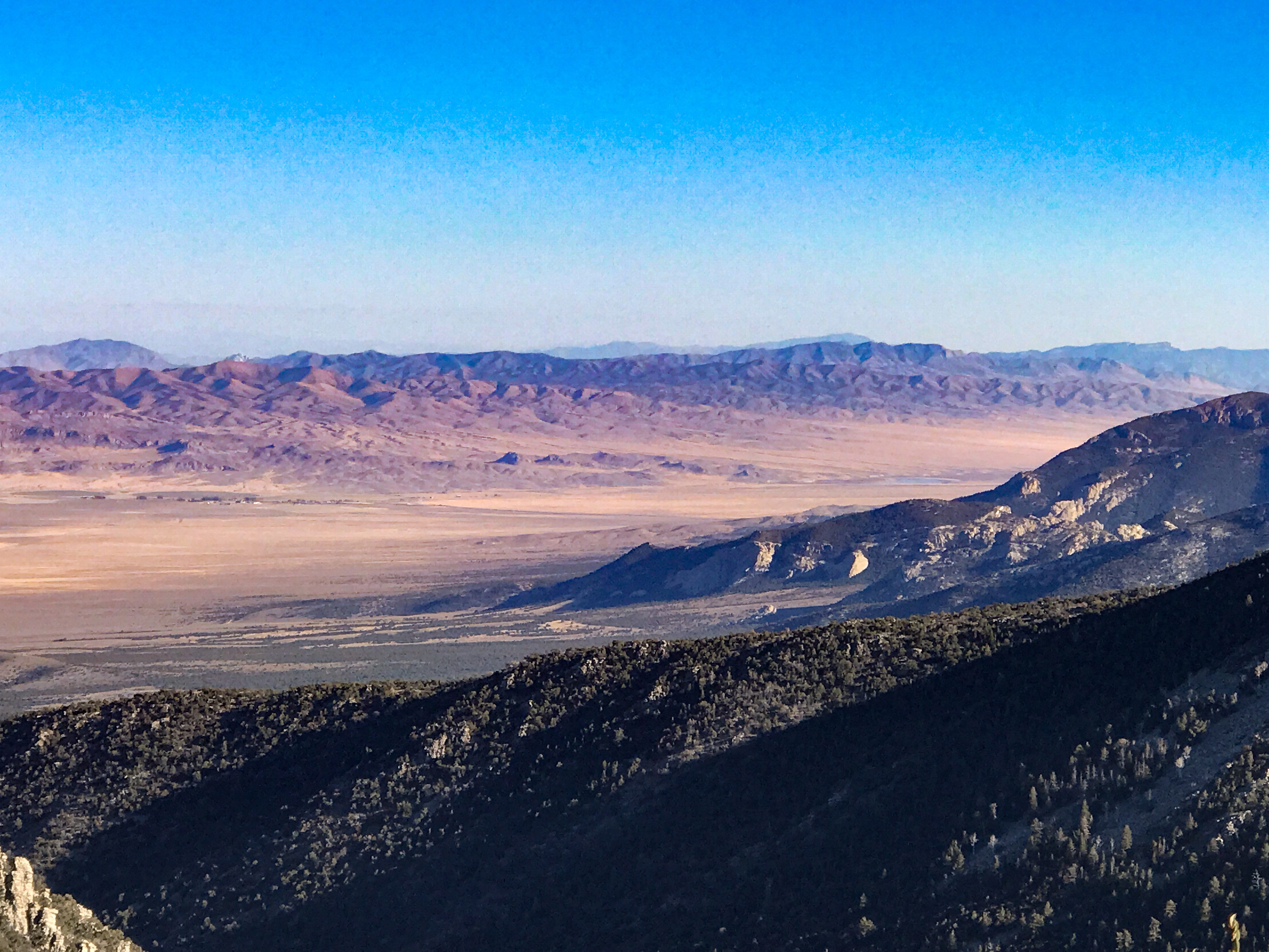
We hiked the one-mile Bright Angel Point Trail at 11am, as well as the outlook platform at Point Imperial, which is an absolute knock-out 180-degree view over the Kaibab and Walhalla Plateaus. Saw a Rock Ptarmigan in low flight and caught a pic of him as he rested in a high pine. Imperial is the highest observation point in the Grand Canyon, and even though today was a bit hazy, we could still see at least 70 miles across the mesa and down into the Navajo Grand Canyon to the southeast.


Looking forward to some splendid autumn hikes here. Up at 5am to hit the trail ASAP tomorrow.
————————————————
Evidently my 40-year-old mental self is making the hiking plans/schedule. Today brought home the reality that it’s my 66-year-old physical self who actually hits the trails and pays the consequences for overdrawing the energy account!
Bright and early this morning we hit the North Kaibab Trail down into the Grand Canyon North Rim. I make this distinction because the North Rim is 1500 feet higher than the south rim. It’s colder, a whole different climate zone up top than the south rim, well-forested (except for the many areas where forest fires have obliterated trees), and pretty nippy in the fall mornings. On the drive we saw a small herd of Buffalo bulls, grazing in the dawn light. Temps were high 30’s when we set out, and we had our puffy jackets, beanie caps, gloves and long pants on. The hike down was absolutely splendid and we were able to observe six distinct layers (out of the ten total) of sedimentary clay, shale and limestone rock lining the canyon walls.


The Canyon itself is really only 250 million years or so old. That’s how long ago the original rift/uplift took place that separated the north side from the south side. The rocks themselves are nearly 2 billion years old, however, and way down at the canyon bottom the rock is actually igneous.
But the real architects of the canyon as it stands today have been wind and the waters of the Colorado River. Long after the initial rift (250 million years ago), perhaps six million years ago, the river started cutting deeper and deeper down into the rock and to carry untold billions of tons of rock and soil away, down into the outflow past the canyon. At that time, all the way up to the construction of the Glen Canyon Dam, the Colorado carried huge amounts of sandstone grit, rocks and soil INTO the canyon from upstream, as well. The grinding action of this sedimentary load is what did the most to wear away the walls and bottom of the canyon. Nowadays, there is almost no sediment in the river as it flows through the canyon (because of the dam), and the water is turquoise blue vs. reddish brown.
Back to the hiking. We had the trail nearly to ourselves for the 2.5 hours it took us to get 5 miles down into the canyon. This is a descent of 3,000 feet and it took us down to the Roaring Springs mile marker on the trail. This allowed us to see four different climate zones, and to discover the reds, yellows, whites, greens and blues of the stones, as well as the mineral deposits flowing over and through them. The soil along the path is VERY dusty loam, having been ground by tens of thousands of hikers per year and a whole slew of mules going down and up. Dust clouds with every footfall.
Close to our turnaround, we began to see a great many green and light blue stains and rocks in the canyon walls, and soon realized that these were in fact blue chert and chalcedony, the precursors to agate. They were just stunning, shot through with sparkles caused by the silica and mica embedded in them. Good thing you cannot collect rocks in the national parks!! I would have had a bundle of specimens!!


Just at the point where the Roaring Spring (responsible for ALL of the water used on the North and South Rims) became visible, George and I said to each other, “We know the ascent back out of the canyon is going to be arduous, let’s turn around now.” I was worried about the effect of ascending to 9,000 feet, he was worried about the heat.
If we’d had either one to deal with, not both, we would likely have enjoyed the hike back up. As it was, the day turned out to be warmer and far less breezy than forecasted. And the number of hikers still coming down as we were coming up was legion! 50% of hikers were unmasked, which made it really a chore for us to have to mask up every single time someone passed us and to leave it on until we were well clear of their aspiration cloud. To be honest, most of the Rim-to-Rim hikers we met along the way looked pretty wasted, as well. We also saw mule riders, and would have gladly hopped aboard at this point.

We labored for 3.5 hours getting back up to the trailhead and counted ourselves lucky to get off before the real heat began. We had hoped our acclimatization to altitude from the summer trip would still be in effect, but alas, it was not. If we were to do this trail again, we’d start at first light and not go as far, stopping instead at the impressive Bridge in the Redwall Limestone.


Believe it or not, we did one more hike this day, the East Rim Trail, a mere 0.5 mile, to see the eastern perspective of the chasm. Totally different atmosphere, more open and the erosions were softer at the edges. To this point, it seems everywhere you go to see the rim, it presents a different face. There is really no way to grasp the enormity of this space, it is so deep and so wide and so eroded into a thousand different side canyons. From the North Rim, the Colorado River is seven miles away. In many places, the two rims are 13 miles apart. But not in the west (where we have yet to visit) – there the walls are much closer together, for reasons we have yet to research.
We slept the Sleep of the Dead after these hikes. Their impact on us was huge, psychologically and physically. And they altered our plans for the next days, as we cannot tackle more long hikes this week in the wake of the North Kaibab. It’s that demanding.
Postscript: at the end of this day, smoke and ashes filled the northeastern sky, visible for most of the drive back to our campsite. Turns out two fires had been carelessly started by humans in the Kaibab Forest, one threatening a general store frequented by visitors and park staff. This just shouldn’t be happening anymore, with lightning strikes already creating so many burns. Tragic and avoidable damage.


——————————————————————–
Today we again rose quite early and drove the hour to the Rim Zone plus another 30 minutes to get out to the peninsula where a series of southeastern hikes and viewpoints can be accessed.
We started with the Cape Final Trail, reputed for its graceful, long ranges and runouts at the Rim. It starts with 1.5 miles through Ponderosa woods, which were so enjoyable and easy after yesterday.

At the rim hikers work their way around Utah Juniper and Pinyon Pine to reach the deeply wrinkled and crevassed limestone edges of the canyon.

The colors are impressive and the topknots on many of the ridges are amusing and unique. Along the approach route, we saw more Buffalo and Ptarmigan.


Thereafter we hiked to Cape Royal, where two of the Rim’s iconic isolated stone islands can be seen. One, named Wotan’s Throne by explorers, is a magnificently huge rectangular precipice capped with white Coconino limestone. The other was dubbed the Temple of Vishnu by an adventurer who had seen the centuries-old Hindu temples of India and thought the profiles resembled each other.


Lots of Buffalo Bush out here, which we’d never encountered. Looks like the indoor jade plant we all used to have in the 1970s.
Also stopped at Walhalla Outlook, from where you can see the Unkar Delta portion of the Colorado River. This near-horseshoe bend is where between 1050 and 1150 AD, Ancestral Puebloans farmed in the winter and migrated up to the Rim in the summer to escape the canyon’s heat. We closed out the day with a stop (and lunch) at Point Encantada. Again, another face of the Grand Canyon, unlike the others.


George and I were again today so fatigued from the hiking (far more modest in length and altitude than the North Kaibab trail) that we decided to cap our North Rim experiences with the hikes already in the bag. Tomorrow we’ll take off for Lee’s Ferry, site of the Navajo Bridge over the Colorado River and float trip launches downstream. More hikes to come.

———————————————————————-
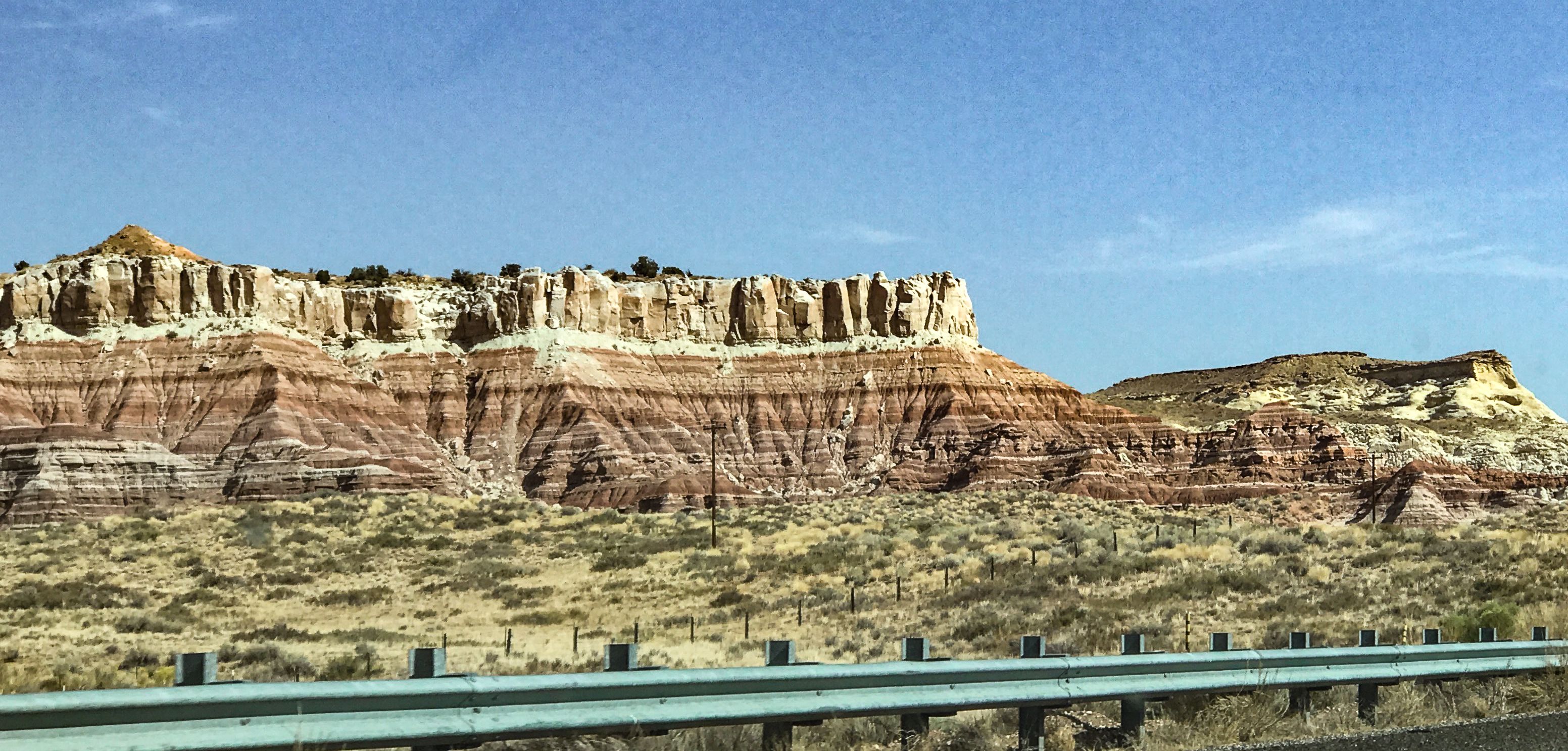
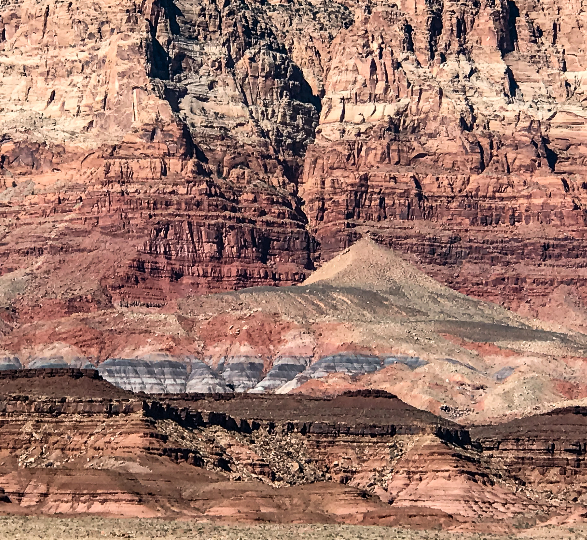
Today is the day when all campgrounds in and around the North Rim close for the season. We packed up and headed east along the Vermilion Cliffs National Monument. If a visitor doesn’t have time for the Grand Canyon but wants to see a sample of the spellbinding geology, he or she couldn’t do better than to drive along the silt/sandstone Vermilion Cliffs! These are not really all the same rock types as in the GC, but they do appear similar to the erosions of the Grand Canyon. And there is such dark red rock, mixed with golden, purple and blue (the latter stained with manganese) that the cliffs can look like a modified rainbow. Quite impressive.

Turns out, this drive is simultaneously on the edge of Vermilion Cliffs, the Grand Canyon and Glen Canyon Recreational Area, as well as the immense Grand Staircase Escalante area of Utah. Ever wonder where the term “Grand Staircase” comes from? Geologist Clarence Dutton named this area for what he saw as a grand stairway of descending cliffs and terraces stretching from the borders of Zion and Bryce Canyon in the west to Lee’s Ferry and Glen Canyon in the east (the basement of the Grand Staircase). All of the layers in the Staircase add up to one vertical mile of sedimentary rocks.

———————————————————-
Wow. We may need to revise our soured opinion on slot canyons. Today’s hike through Cathedral Wash was technically a slot canyon hike, but a thrilling, highly varied one, and really so much fun.
Lee’s Ferry/Vermilion Cliffs is home to a variety of trails, most of them in canyons that drain to the Colorado River. Yesterday’s research did not reveal a decent trailhead to Marble Canyon, likely the most famous hike in the region. So, we spun the random hike selector wheel and came up with Cathedral Wash, a mere mile from the campground, for today. Super-lucky pick!!!
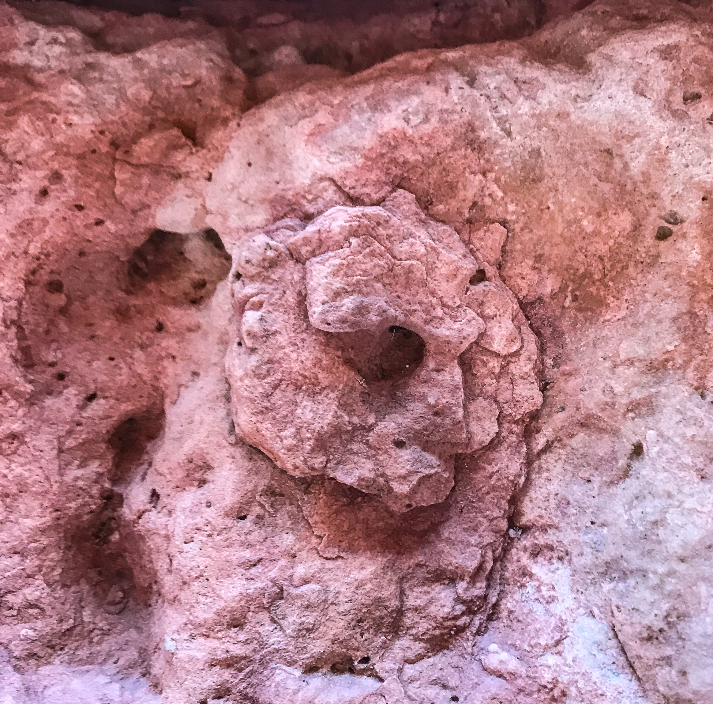
The trail starts on the north side of Lee’s Ferry Road and goes under the road via a cement culvert. Then the fun starts. Just as in the Grand Canyon, we walked down eons of geologic time through Pink Cliffs (the Claron Sandstone Formation, 60M yrs old), Grey Cliffs (Wahweap Limestone, 130M yrs old), White Cliffs (Navajo White Sandstone, 150M yrs old) and Vermilion Cliffs (Moenave and Kayenta Sandstone Formation, 200M yrs old). It was thrilling to see the sinuous layers of sandstone and limestone, to recognize ancient shells and coquina embedded in the limestone which were replaced by silicious (glittery) matrix over millennia.

This was difficult rock scrambling, ledge walking, hand-over-hand boulder climbing, and we LOVED it!! There were giant slabs of sandstone that had broken off or slumped down from the 100-foot walls of the canyon, gigantic hunks of limestone that had been sheared off by rocks borne on the flood waters coursing through the canyon, and so many deep pour overs (like waterfalls, but dry until flood season), we lost count. Great bowls have been scoured into the wash by the traveling boulders, grit and sand. There are quite a number of helpful cairns hinting at the best spots for getting around these deep (10-15’) bowls, but we still had to constantly strategize about where the best hand and footholds were and how far a good path above the bowl would last before we had to change sides of the canyon. Just what we love!! A real sense of accomplishment.


We were quite happy to make it to the Colorado River at the delta end of the canyon, its waters clear, blue and not too cold. After a rest and our energy drinks at the river’s edge, we made our way all the way back to the trailhead, meeting (as usual) far many more hikers on the way back. One pair of 20-something women said, “We were waiting to see how you made it past the slabs before we attempted it.” That’s always super-fun to hear!!!
————————————————————-
Today we’re in Page, AZ, on the way to Utah’s other national parks. We had to go see what all the fuss is about with Horseshoe Bend Overlook. Not best viewed in the early hours, but we did see it, and it’s quite lovely. We would not go again because the best viewing is in the hottest hours of the day, but it was nice to see the Bend, nonetheless.


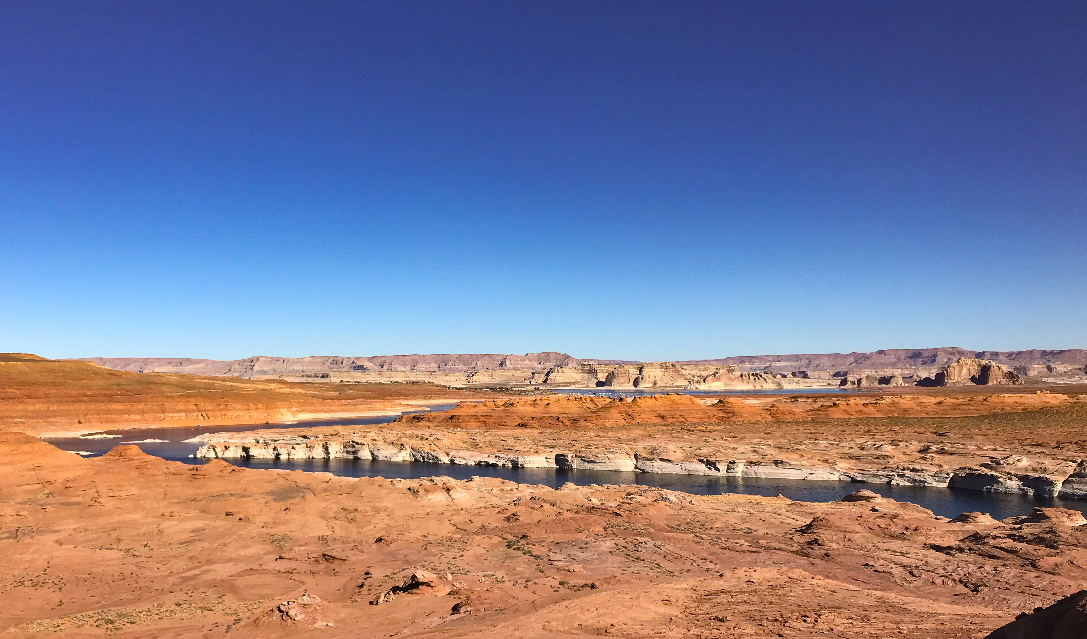
We also drove out to Wahweap Overlook to see Glen Canyon and Lake Powell. The reservoir is the prettiest we’ve ever seen, far nicer than Lake Mead, etc. Tons to do on the water, as well. Surrounded by the eye-popping sculpted sandstone of Navajo lands, there is beauty in every direction, and Lake Powell has hundreds of canyons and hundreds of miles to cruise down. It certainly seems like what the Grand Canyon would be, if the Colorado River were dammed to the west (but perish the thought!!)


Last hike here was to Hanging Gardens, a seep in the sandstone cliffs where ferns and other water-loving plants have taken hold. The oasis was lovely, but the real draw for this hike is the outlook over the Navajo lands. Hiking directly in the sandstone cliffs is an experience like no other, because you are intimately in touch with the carved undulations, pockmarks, crossbedding, varied and wonderful colorations, and ridges created by the seepage of silicated water to bond the rocks together. Sparkles aplenty!
While sitting on a crested rock, we heard a Navajo flute playing into the canyon, about 75 feet away from us. We chatted a bit with the player, he played his wooden flute and an interesting two-tubed flute, and it was an amazing experience. He normally leads tours into Antelope Canyon and plays his flute while he hikes, but this year the canyon is closed, and all tours are off. Tough times for the Tribe.


————————————————————–
Now on the way to the other UT national parks, starting with Bryce Canyon. Did a great recon drive on first night, decided to start with 8-mile Fairyland Trail next morning. Good decision, as it was quite magical in the early AM. Landscape is mostly clay slopes, with some hard limestone capstones, some dolomite (a harder limestone that nature fortifies with magnesium). The resulting walls, hoodoos and spires could be interpreted as fairies, brigades of soldiers, towers, castles, morel mushrooms, the Tower Bridge of London (!), Thor’s Hammer, or any number of other fanciful creatures/structures.


Crowds are still a big problem and thus we now divide our time 1/3 to the national park trails and 2/3 to national monuments, state parks and national forest trails. At present there doesn’t seem to be such a thing as “off-season,” as parents can do virtual schooling with their kids while on the road. Park staff say they’ve never seen a year like 2020 for crowds.
A petrified forest state park outside Escalante, UT, caught our interest as it is always fun to see 700-ton agatized trees. Nice specimens, no crowds. The specimens here date back 150 million years. They were a now-extinct member of the pine family most directly related to Norfolk Island Pines.


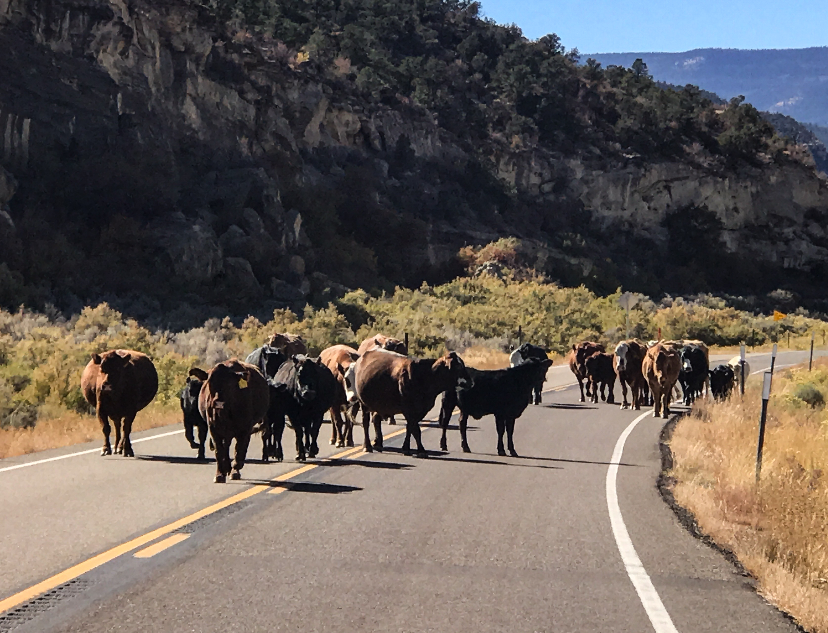
On the way home from the Pet Forest, we happened upon a Dad rancher on horseback with his young son, also mounted up. The former was obviously teaching the latter how to herd cattle to a new field when a young calf got away. They sure had their hands full trying to chase it down, even with cow dogs. The older cows knew what to do, thank goodness. Head for the next meal.


This morning’s 4.5-mile hike was through the Red Canyon National Forest trails. Here, lots of claystone hoodoos are topped by basalt, therefore they’re a little differently shaped than the Bryce hoodoos. Basalt is igneous and very hard. Red Canyon’s hoodoos are fatter than Bryce’s. The basalt capstone looks like a whole library of books on top, as it fractures vertically.


Lots of landscapes in Grand Staircase Escalante look rainbow-like in hues, because they contain so many minerals: copper, cobalt, chromium and aluminum produce blue green; iron produces red, yellow and orange (as well as blue green if it doesn’t oxidize); manganese makes pink; and carbon and manganese make black. I love the chemistry of color.
Grand Staircase Escalante is also home to many Bristlecone Pine trees, the oldest living conifer species on earth. They are quite handsome, slow-growing, and resemble the Monkey Puzzle trees seen in the south and in southern England. Some have clocked in at 5,800 years old.
————————————————————
Feeling a little tuckered today, we headed to Kodachrome Basin State Park (doesn’t that sound colorful?) for an easy 6-miler today through the desert and around sculpted clay formations.


Lovely hike, we saw the Ballerina’s Foot (you know it when you see it) and the Hat Shop (several pinnacles with balanced rocks on them). Then drove out to see Grosvenor’s Arch at the end of 10 miles of bumpy dirt road. Must be a lot of people like me who remember reading about this arch in grade school. It’s named after the founder of National Geographic Society, and is such a gorgeous work of nature. Quite a lot of people made the drive, and the road was VERY dusty as a result!
————————————————————
Last hike in Bryce Canyon National Park today. We tackled Peekaboo Loop Trail, a 5-mile long and 1200’ deep descent into the basement of Bryce Canyon. Today’s sunrise was tinged with forest fire smoke blown in by a stiff wind from Washington and Oregon. Meanwhile seven new ferocious fires are burning in Colorado. Our beloved western state forests are perishing.
We started at 8800’ on Bryce Point, and the dry, firm slopes (average 8% angle of descent) were completely empty at our start. At the halfway point traffic started to pick up, as did the horse droppings on the trail.


I am still amazed that most people (including me) think of these hoodoos and other imaginative wind-made rock sculptures as sandstone, instead of the prevalent limestone and claystone of one ratio or another. Most of the rock is pink, peach, terra cotta or ivory but splashes of lilac, carmine, mauve, and olive green are here as well. What a magical place!! You can imagine yourself at the Acropolis, under the sea at Atlantis, surrounded by scary stone giants or animals, on the Chinese wall, or in a living chess game. The 100,000 statuesque and grotesque forms can be anything!!
We had a few hours left in the early afternoon so went exploring on backroads. Always fun. One route was so powder-dusty, it was like driving in two feet of corn starch. The other road was much better and led to the backside of the national park. Stunning vistas. We capped off the drive with some dry wash-walking, which yielded a pocketful of rocks with gorgeous colorations. Our own personal palette of Bryce Canyon, but legally collected from next door at the bottom of Sheep Creek!!

—————————————————————
Today, our last day before driving north to Capitol Reef National Park, was WOW!!!!!!
Suffering from a little hiker fatigue, we drove the Burr Trail Scenic Backway, reputed to be the most beautiful two-lane highway in Utah. We now agree. It is stunning and worth a day’s investment of time.
100 miles across millions of years in geologic time, it was just spellbinding. We traversed fossilized sand dunes, drove a narrow “hogback” ridge at the top of a white slickrock mountain, descended into a copper-colored claystone canyon with vertical walls, and hit the turnaround point at Water Pocket Fold, the main geologic phenomenon that characterizes the entire Capitol Reef formation. We also saw incredible majestic Aspen and Cottonwood colonies ablaze in bright yellow, hugging the canyons’ riverbanks.
70 million years ago, this area underwent a squeeze play between two tectonic plates, resulting in the ground kinking upward like a lopsided wrinkle. It wasn’t a fault, but a stylized backwards S-fold. The west side rose up 7,000 feet higher than the east side. There has been significant erosion of the elevation difference since then, making the elevation more like 5,800 on the west side, but when we drove through the wrinkle today and down a dizzying set of hairpin turns to get to the other side, it seemed plenty elevated to us!!!
Such a fantastically unique feature to behold, and it got even better when we drove up the amusingly named Upper Muley Twist Canyon at the fold’s summit, to view the earth’s wrinkle from Strike Valley Overlook. This never gets old.
To our delight, we’ve found that this part of Utah is pretty crunchy. For the uninitiated, that means the folks who live here are environmentally conscious, like organic food and spend a lot of time out in nature. How great is that?!? We have found part of our tribe again!
————————————————————
Sitting warm and snug in our motor home as snow swirls around us. We’re in Torrey, UT, just outside of Capitol Reef National Park, which is quite spectacular.

The drive northeast from Bryce Canyon took us through the Fishlake National Forest, where the world’s largest aspen grove lives. It’s called the Pando Grove, and I believe it’s even bigger than online info sources suggest, at 130 acres. We saw the community for miles on both side of the highway. Immense!!
Today’s hike was bounded by the darkness (starting after 8am now) and the rain (had to be done before noon). Thus, we opted for a 4-miler upslope from Capitol Gorge at the end of the park road, called The Golden Throne (Hey, I don’t name ‘em, we just hike ‘em!).


It was a wonderful trail over slickrock sandstone slopes, great traction and only a few dozen high steps to climb over. Rock colors were mesmerizing, layers of rock looked like filo dough, the vegetation next to the trail seemed in great shape, and the overlooks were divine. The summit at 6,000 was still 1,000 feet lower than the upright Golden Throne monolith at the top of the ridgeline. A great hike, all the way around. The rain started 15 minutes after we got back to the car. Did I mention it’s snowing now?
It is striking how sandstone and claystone can sometimes deceive the eye. There are cream-colored slickrock mountains here that resemble the grey granite plutons of Yosemite (e.g., the straight walls of El Capitan, the rounded curves of Sentinel or Half Dome). Hard to believe! And they exfoliate similarly, sending slabs and shingles of rock crashing to the canyon floor. Then you look at the next face, and its dark rust or brilliant ochre or creamy peach and you remember that this is Utah!
——————————————————————–
Today is the coldest day we’ve spent in the Moho! At 8am it was 13 degrees, and the peak temp was only 34 degrees by 4pm. But we still made lemonade with this lemon of a day!
It snowed in the Henry Mountains on the east side of the park, but so far, no snow or rain here.
Cottonwood Wash was our chosen trail, down the Notom Road (east of park), starting at 12:30pm. What a gem this trail was. Hike was fairly short (4.5 miles, flat) and we both had three layers of clothing, balaclavas and gloves on. Wind was gusting to 25 mph, so we hoofed it out there double-time and loved it.
This is now our fifth slot canyon, and here’s what we’ve learned: if weather is warm and dry, mornings are best, afternoons are close second (best light). If weather is cold, midday is best. If weather is rainy, stay OUT. Shorter slots are better. We also love the slot canyons that are not straight (more interesting) and have lots of offshoots, but you can’t always get that detail beforehand.
What was nice about Cottonwood Wash: colors (sandstone and shale varied in colors and intensity), walking surface (some boulder scrambling, but footing very good), sinuous bends in rock surfaces and lots of interesting desert varnish on rocks. Lightly traveled by hikers. Also, everywhere we found lovely blue shale and lots of calcium carbonate-encrusted sandstone, making for great eye candy. Upon exiting the canyon, we saw the now gloriously white-blanketed Henry Mountains bathed in clear afternoon light. Heavenly.
Stopped briefly on the way home to drive the Panorama/Goosenecks road in the park. Great lookouts, especially to see the Fremont River in all its red muddy radiance.

Back at the Moho now, enjoying hot cocoa and blankets. It will be another chilly night and chilly morning, so tomorrow’s hike will be in the late AM as well.
—————————————————————
Last day in Capitol Reef, and longest hike of the visit here: Cohab Canyon to Frying Pan Trail to Cassidy Arch. 8.5 miles and 2,200’ ascent. This was a bodacious, spectacular hike, and we loved nearly every minute.
On the drive out to the Trailhead, we glimpsed a mule deer buck with enormous antlers. Rangers say they are prized here because the high amount of lime in the groundwater makes the racks grow big, strong and fast. Calcium (carbonate) really does make for strong bones and antlers!
To start things off, the drinking water tubes in our backpacks were frozen! Then there were the 500 feet of vertical stairs/dozens of hairpin curves ascending from the trailhead. Lots of easily winded hikers might be scared off by this, but even with the huffing and puffing, we enjoyed the many lava bombs resting along the path/used as stair treads. Still, mighty glad to get to the peak of Cohab Canyon thereafter. It’s a high and wide slot canyon, running for perhaps 2 miles, and following this, the trail leads into a series of ups and downs between another three canyons over Frying Pan Trail (named, in all likelihood, because it gets hotter than Hell’s Kitchen in the summer) to some awesome vistas over the rimrock edges.
There is a great deal of slickrock on this trail, which we enjoy immensely. It gives good traction to the hiking boots, alleviates slogging up and down rocks and steps or sand, and you can make good time. But there is a lot of altitude gain and loss over Frying Pan, so we were pretty tired at the end.
The final installment of this hike, Cassidy Arch, led us out past some splendid sandstone wind-sculpted surfaces, and we reveled in the beautiful colors, especially as the golden afternoon sun made them all the more vivid. More slickrock to get out to the arch.


Here’s where it became not so pleasant: lots of people, a bit like being at Disney, lots of noise and selfie antics at the arch. We treasure the quiet to silently enjoy nature’s masterpieces, but that is not everyone’s thing. After a few photos, we headed back for the return hike. Waiting for us in the campground was a gaggle of mallard ducks, fully prepared to share dinner with the campers. We obliged them with lettuce!

Loved the slump rocks, etched stone, water-carved slickrock, abundant and non-complaining pinyon pines everywhere along the path, long vistas, breathtaking heights of the summits, and even the little lizards along the way. There’s lots more to explore here, but we’ll be breaking camp and heading out tomorrow for Canyonlands National Park. Thanks for the fabulous hikes, Capitol Reef!!
—————————————————————-
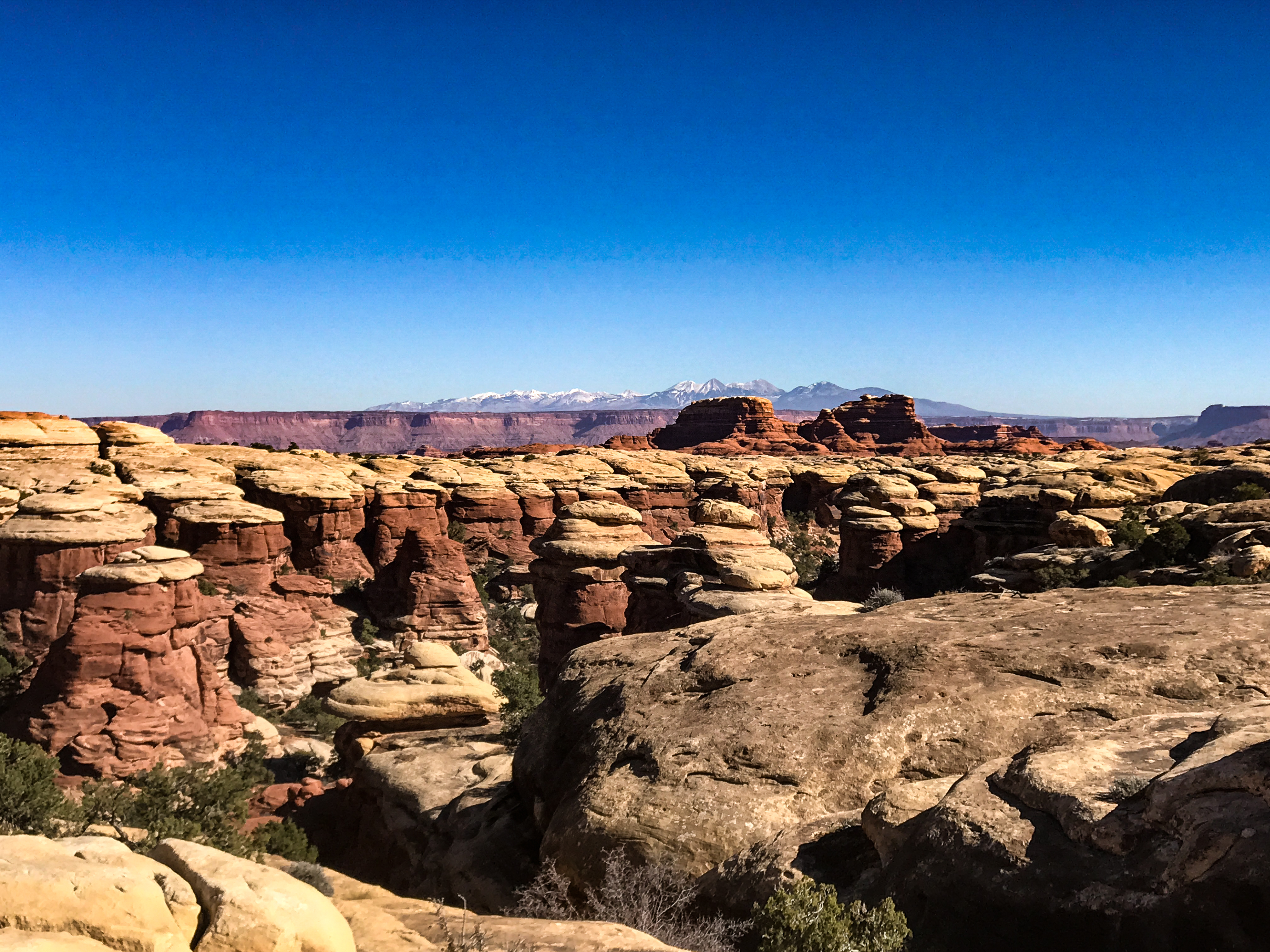
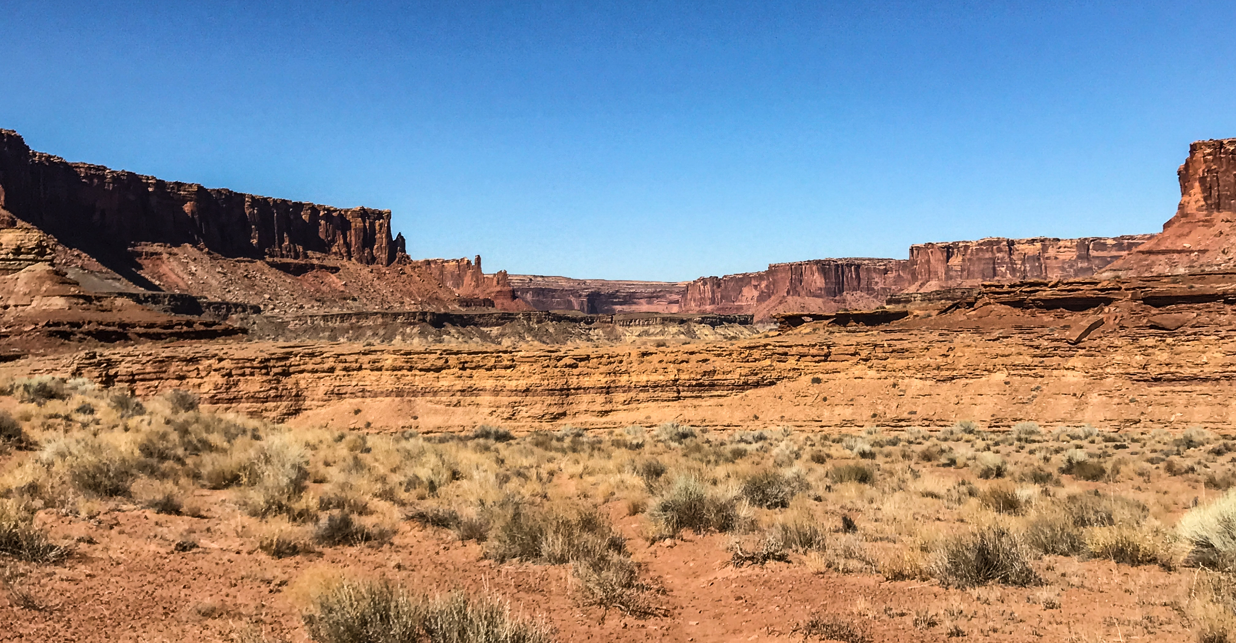
Eastward to Canyonlands/Arches, our last National Park for the state of Utah. We know we will have to come to Canyonlands multiple times, as there are just too many hikes there to do in one trip.
The road from Torrey to Moab is a strange one, like driving 100 miles through the badlands of South Dakota. Most of the landscape is dry and without vegetation and consists of grey and brown piles of cemented clay dust. A bit like driving through one gigantic tailings pit. Even with the muddy Fremont River next to the road, it wasn’t until the Fremont’s confluence with the aptly named Dirty Devil River that we again saw cattle grazing, green growth and vibrant communities.
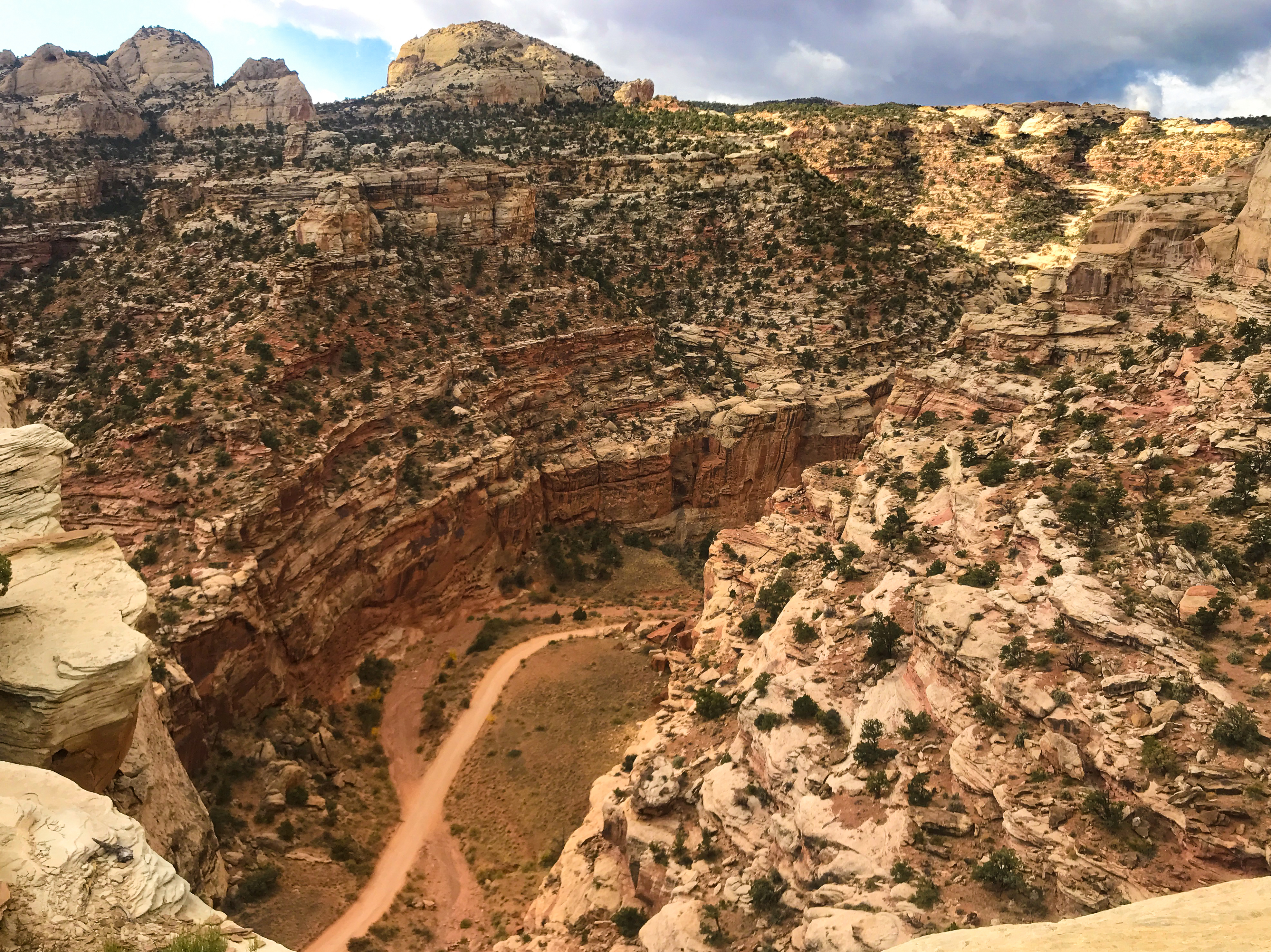
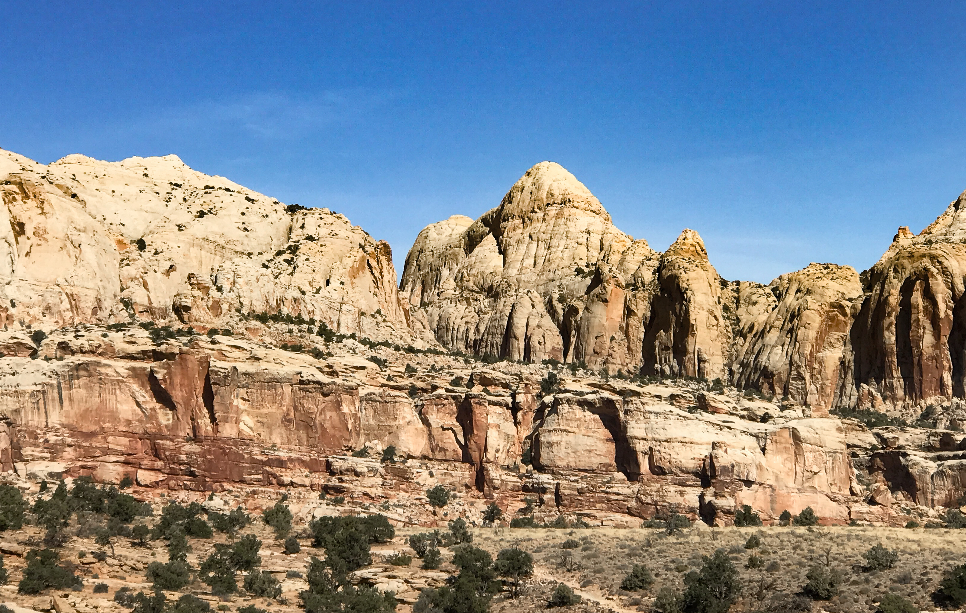
Now in Moab, we drove briefly through Canyonlands North (Island in the Sky) this afternoon to assess hiking options. What a huge, broad and deep set of hard sandstone canyons is here. From mesa top at 5,000 feet+, you can see up to 150 miles away. It seems to go on forever, unlike many of the other parks visited this trip.

We’ll drive south to the Needles area of the park tomorrow to hike in Chesler Park, as it’s one of the shorter trails we plan to do, then we’ll come back north to see some of Arches National Park later in the afternoon.
——————————————————————
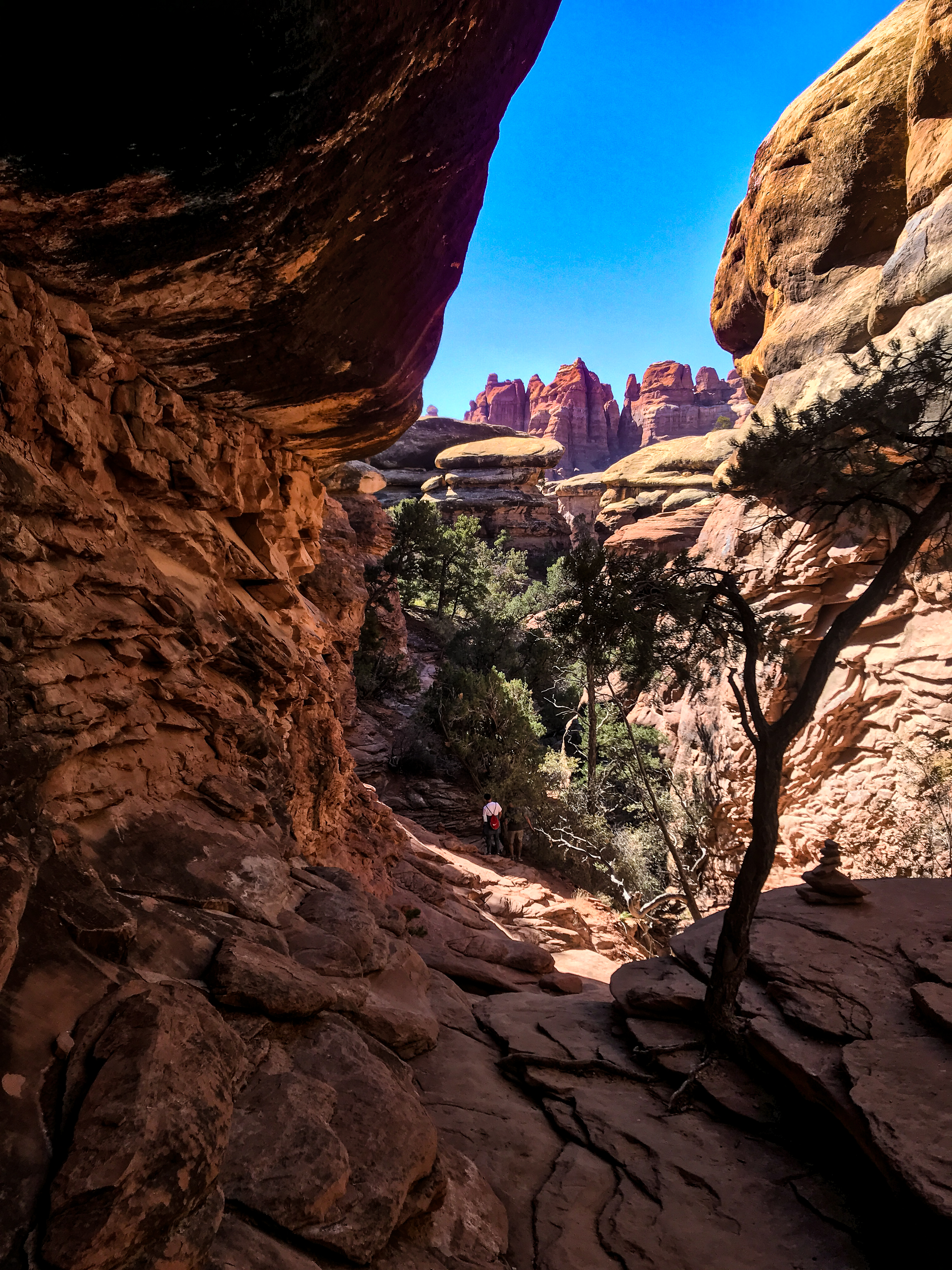
Holy Toot! The Needles portion of Canyonlands is a l-o-n-g way from Moab!! The drive to our trailhead was 90 minutes, over highway, secondary roads and dirt trails! The park itself is one of the largest in the NPS, and Chesler Park is at one far end. But worth it. It’s best, for this park, to plan on camping at the north end for a couple days and then moving to the south end for the rest of one’s stay. We’ll do just that the next time we’re here.
In such a large National Park, it is enthralling to see so much wilderness as you drive the long miles. Thousands of acres where you are certain that the feet of humanity do not wander and the animals, plants, trees and soils have their habitat all to themselves.
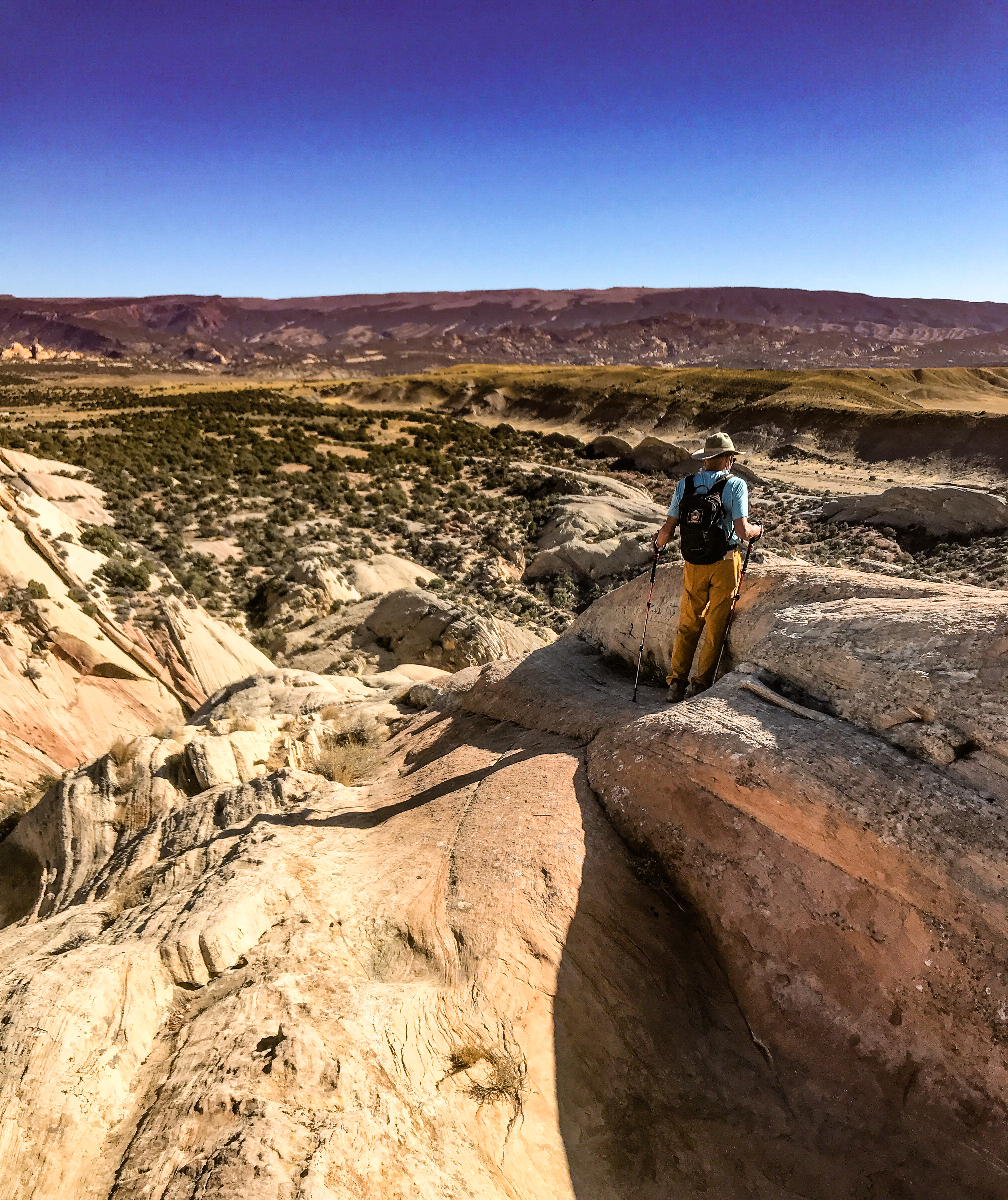
On the NPS map you see roads that appear able to take you to certain trailheads, but the ranger advised us that our planned course took us over the “most technical dirt road in all of Utah.” In this context as well as in the hiking context as well, “technical” means you will need special equipment. Either a beater 4×4 that you don’t care about dinging up, or mountaineering gear to get up the verticals. We’re not in either category, so we decided to do the Elephant Hill Trail to Chesler Park, instead of Devil’s Kitchen inside Chesler Park. And that turned out to be a great call. What a marvelous hike. Just short of six miles, mostly over sandstone slickrock, superb views and fascinating rocks. Perfect combination. And no car scrapes or blowouts. On the way home we saw numerous climbers scaling the vertical slopes.


The weather is getting to be very pleasant for all-day hiking now, with temps between the high 30’s and low 60’s. Just what we love.
This National Park was originally centered around the southern Needles geography, but this region lends itself better to back country and overnight hikes, thus removing it from many peoples’ targets. For those of us limited to day hikes, the NPS added the northern geography, referred to as “Island in the Sky” because it is a high mesa with deep canyons on all sides. This is also a lovely territory, but much more crowded.
Our visit to Arches NP, just on the edge of Moab, was wonderful, but also crowded. It’s a small park which you can effectively visit just on drive-around. Our trail was at Tower Arch, again a fair drive as it involved 45 minutes on blacktop and 45 min on dirt road. The trail itself was a steep scramble over boulders for the first quarter mile, then a nice roly-poly path through slickrock, desert gravel and soft sand for the rest of the 3.5 miles. The Tower Arch at the end was quite stunning.


Our final hike (9-mile Syncline Loop) was subject to change, as two different info sources claimed different altitude changes and we opted to be conservative as one quoted a 2,800’ climb at the end. This was uncomfortably close to the strenuousness of North Kaibab trail at Grand Canyon which kicked our butts for two days, so we decided instead to hike the Upheaval Canyon trail. Again, a long approach drive: 45 min on gravel Mineral Road across the mesa and a hugely steep hairpin drop to the Colorado River-side White Rim Road, which also took 35 min to travel to the trailhead. Wow. So many mountain bikes take this trip, as well. Amazing. We passed a peloton of racers on a 100-mile/day rally. Close to Tour de France-grade athletes.


Upheaval Canyon lopes along the canyon bottom for 3.5 miles, then intersects with the route we’d planned to take. It’s the kind of hike that makes you feel very small and insignificant as you walk along wide washes and 1500’ vertical canyon walls. Not strenuous, it gives you lots of time to examine the rocks that have been tumbled in the wash.


On the way back up White Rim and Mineral Road, we witnessed hang gliders/parachutists coming down the hairpin canyon as we drove back up. Then there was the Jeep rollover accident halfway back up the mesa. Someone apparently took the gravel road curve a little too fast for the traction they had with their vehicle. Thank goodness it was on flat ground.
As our final foot adventure in Canyonlands this trip, we drove over to the Upheaval Dome Outlooks because they gave us at least a visual sighting of what Syncline Loop would have been. Ran into a couple people up there who’d done Syncline, and that confirmed our intention to go ahead and do it on the next trip. The outlooks were dazzling and added enough mileage to our day to top it off at 8 miles. Perfect.


Before we completely leave the realm of Utah National Parks, here’s our collection of weird and colorful UT place names encountered (though not nearly as wacky as ski run names):
- Hell Roaring Canyon
- Fern’s Nipple
- Horsethief Spring
- Potato Bottom
- Dead Horse Point
- Oowah
- Professor Valley
- Showerbath Canyon
- Hell’s Backbone Road
- Phipps-Death Hollow
- Upper Muley Twist Canyon
- Stink Flats
- Goatwater Point
- Cad’s Crotch
- Crocodile Hog Canyon
- Big Hummer
- Ding Dang Canyon
——————————————————————————–
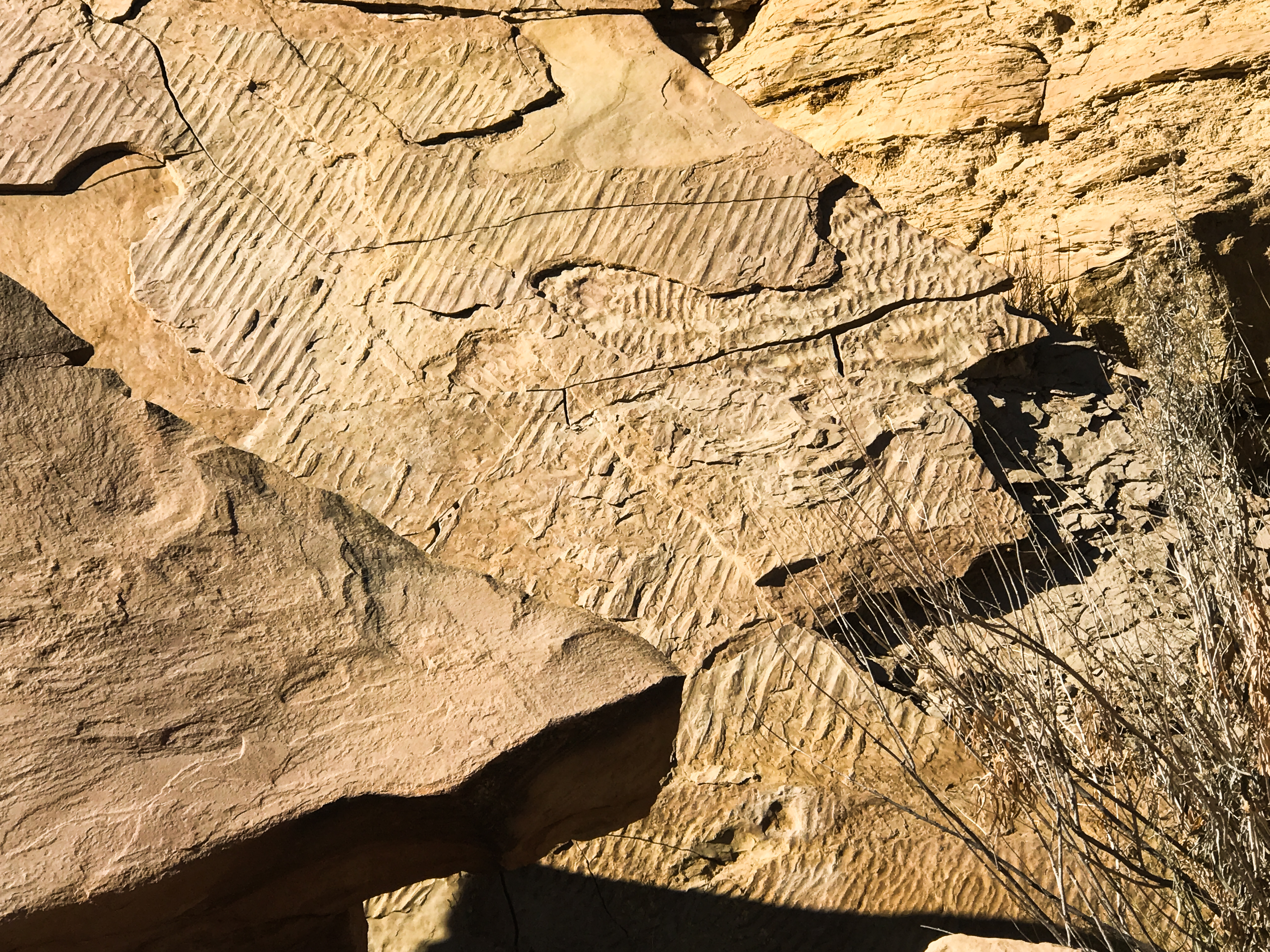
As our last destination in the state of Utah, we visited the Dinosaur National Monument outside of Vernal, UT (overlapping into Colorado). What a treat this was!!
Firstly, this is a world-class dino fossil site, one of the very best anywhere. It’s so significant, it has served as the research site for paleontology programs from UT, MT and other neighboring states. Fabulous.

The short version of the backstory: in 1909 the very first find was discovered in the Morrison Formation geology here, and it eventually yielded 5,000 dinosaurs in partial and/or complete form!!!!! Sadly, most of the specimens were sold off to museums all over the world, but the paleontologist Earl Douglass who made the first find requested that what remained be left in situ in the revealed rock mountainside and that the slope be enclosed in a museum for all to see how the bones came to rest and be fossilized in the sandstone and clay.

When you enter the Carnegie Dinosaur Quarry Building, you see just that: femurs and metatarsals and blades and triceps and lots and lots of spines and one skull (very rare to find, as the bones are so easily broken), still embedded in the stone. There are a great many bones of the gigantic vegetarian Diplodocus, as well as the voracious meat-eater Allosaurus and the formidable Stegosaurus. Several new dinosaurs were also discovered here in the 1950s-60s, including the (speculatively) zebra-striped herbivore Camarasaurus, and just in this century, Abydosaurus (another carnivore).


Time only allowed us to get in one hike at the monument, but it was a good one. The trail was a combination of the Sounds of Silence and the Desert Voices paths, for a total of 6.4 miles. Great ups and downs through the Morrison Formation sandstone from Jurassic times, as well as the Entrada Sandstone and Carmel Formation. Colors were wild, and the trail led us to the unusual Split Mountain, through which the Green River rushes in springtime. Saw two bighorn sheep on the opposite shore. On the final ¼ mile, hikers are invited to scale a high promontory of sandstone (300 feet) to gain a 360-degree lookout over the landscape, which we did. Peak experience!!!!


We’ll come back to Dinosaur National Monument. Still have to investigate the Colorado side, and take more hikes. The mountains are just that beautiful.
———————————————————————————-
Last night was the 2020 Presidential Election. Such a stressful night, and now we are waiting for the final outcome of voting in Georgia, Pennsylvania, North Carolina, Arizona and Nevada. What a nail-biter this has been. We were devastated last night to think that the Biden/Harris team would lose, and now it seems that momentum is on their side. But it’s not over until the last vote is counted.
We pulled into Baker, Nevada for a short visit to Great Basin National Park, one of the least visited NPs in the US. It’s wonderful!!!! GBNP showcases the enormous Great Basin Desert, spread over almost all of NV as well as corners of UT, ID, OR and CA. The basin is a large, shallow depression where no water escapes to rivers outside its boundaries, and it contains many minor mountain ranges, one of the largest of which is the Snake Range in the park itself. Wheeler Peak (part of the Snake Range), is a limestone behemoth at 13,063’ in the middle of the park. It’s surrounded by shorter peaks and is actually a verdant island of life amid a sea of sagebrush and sand. We’ll be out hiking the slopes tomorrow.
———————————————————————————-
It’s still a waiting game on the national election. As far as we can tell, the ONLY good thing about a post-election results delay that it gives us all a chance to get used to the emerging trends, and maybe that’s useful, I don’t know. We should know final results by…tomorrow night…maybe.
At the very well- informed park ranger’s advice, today we opted for an 8-mile hike up Snake Creek to the summit at 10,500’ Johnson Lake. Such great advice!


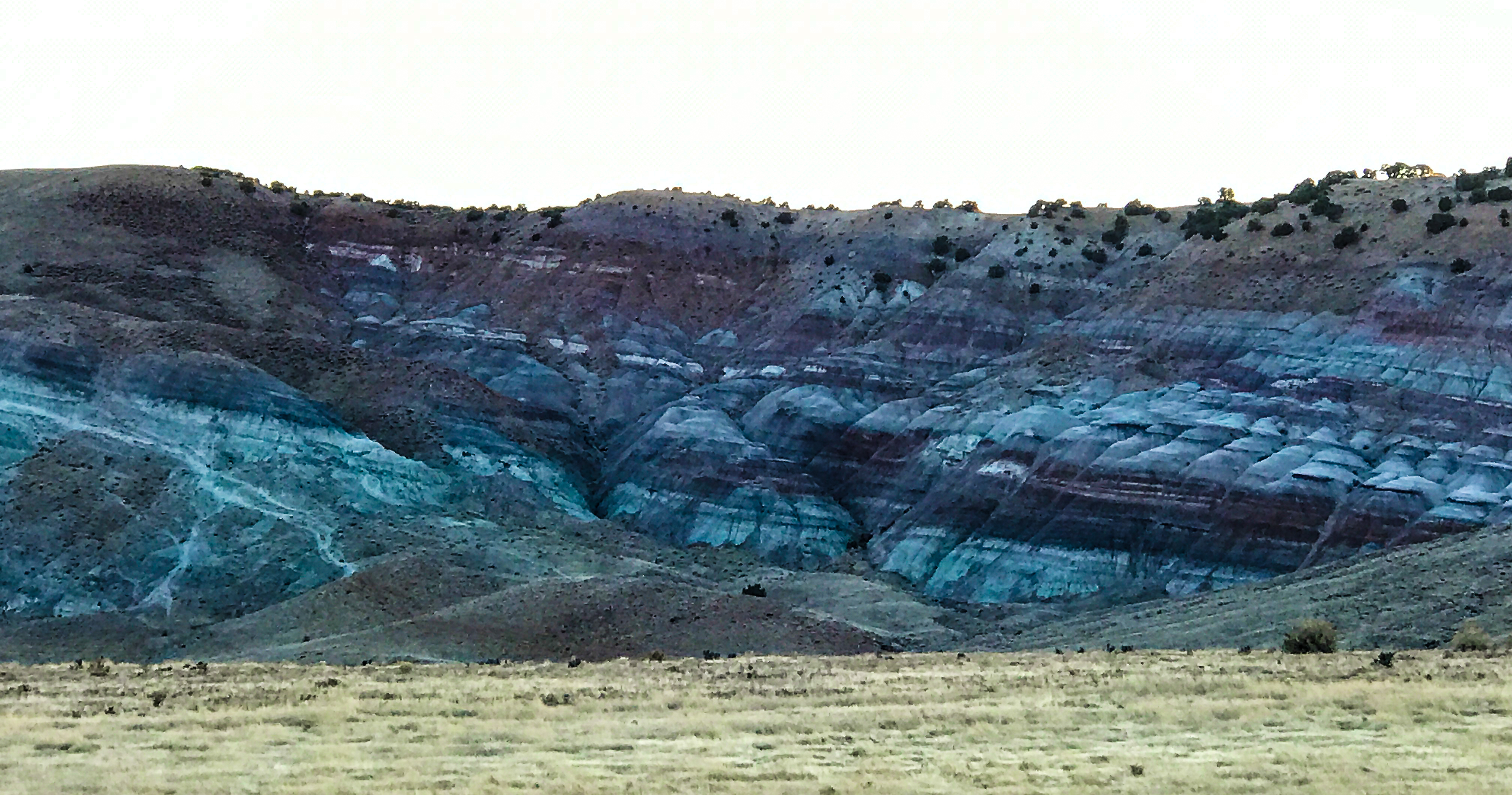
This trail offered us the chance to see most of the varied geology in the park: lots of iron-stained granite, an amazing amount of large white marble chunks with dark streaks through them, discontinuous bands of limestone in the hillsides, and beautiful thriving Mountain Mahogany, Manzanita, Douglas Fir and Lodgepole Pines. A crown jewel in the Great Basin Forests is the presence of very old Aspen trees. Longevity is not typical for Aspens, but numerous of these specimens are more than 8 feet in circumference. The groves are very healthy, and back during peak color, these slopes must have been resplendent in gold and orange.
This area was part of a boom in tungsten mining in the 1910-1940 era, when the metal was needed for incandescent light filaments and to strengthen steel. Tungsten is often found in low-grade marble deposits, and there are still remnants of the mine and mill upslope. The last mile to the summit was a total grind (no pun intended), as it was sheer rock field. But the outlook was worth the struggle, as we saw the craggy top of a large bowl carve-out in the mountain, the scree-laden slopes to the south of Johnson Lake, and the far-distant valley out in the east. Johnson Lake was covered in skim ice on one side, as were numerous spring-fed streams at the mountain top. As long as we kept moving, we were very comfortable in the low-40’s/high-30’s temperature up top.
The summit shows the remains of open-pit tungsten mining: the ore bucket suspended from the slope, the boulders cast aside as miners sorted through the ore deposits, great white and black marble chunks which show tungsten streaks. Thank goodness whatever detrimental effects occurred from mining have disappeared since the deposits were abandoned. Nowadays elk have the mountaintop largely to themselves.
The return trail to our car was also fascinating, as it took us an alternate route along Dead Lake and Snake Creek, revealing a constant stream of iron-stained granite fragments with highly vivid colors. Total eye candy.
We had the entire trail to ourselves and were able to hear what the rangers believe was a noisy and unusual chat between three Clark’s Nutcrackers. We also saw several of John Muir’s beloved dipper birds flitting around the creeks and springs. Finally, a thrill to see three Northern Goshawks cavorting with one another in the skies above at 10,000 feet. Perfection, and a peak experience.
The day ended with a drive out to a remote point to look for migrating elk herds feeding in the uplands. Getting there took us through a large patch of severe burn from forest fires two years ago. At the end we saw 3-4 elk, but it was prematurely dark last night with no sunset to speak of, so not quite what we were hoping for. But every adventure contains the risk that we will not find what we’re looking for. At this point, the risk is low – we are nearly always delighted by what lies on the trail.
———————————————————————————–
We’re once again full-on into the Basin and Range geography as we drive west across the midsection of Nevada on the so-called Loneliest Highway in America, Highway 50. There are 15 pairs of valleys (basins) and minor mountain ranges from Baker to Reno. Fifteen passes, and 15 windy valleys to transit. As mentioned before, this was the crumple zone when the Pacific plate rammed into the west coast and created the Sierra Mountains as well as the western uplift of the Rocky Mountains. Any topo map of Nevada will show you a state that looks like wide-wale corduroy.
We’ve arrived in the High Sierras of California, and at a decision: we’re turning around tomorrow and heading for home. Weather is suddenly just too cold and snowy and rainy in CA to continue with our plan of record and expect to still hike, and the snowy forecast stretches out for at least two of our last four scheduled weeks.
It’s time to call it a day. We’re very happy for California to get the precipitation, and ecstatic that the final election results show the Biden/Harris team to be the winners and President/Vice President Elect. It’s a good time to go home, quarantine and fervently hope that the American people decide to aggressively fight the COVID virus into submission. This has been a wonderful adventure, but the hard work now begins. America, we must mask up, socially distance and drive the number of positively infected way down. And then be about the business of restoring respect, compassion and responsible leadership within these 50 states.
We have royally enjoyed Utah’s (and 1 Arizona!) national parks and surroundings. Zion with its mighty vertical towers, North Rim of the Grand Canyon with its endless winding crenellated canyons, Bryce with its wind-eroded pinnacles, Capitol Reef’s gigantic crumple fold and high crowns, Canyonlands with its vast open gorges, and Arches with, well, its arches. But we love the secret, quiet wonders just as much, if not more: Dinosaur NM, Great Basin NP and Valley of Fire State Park. They’ll be calling us back, and we’ll gladly answer the call!