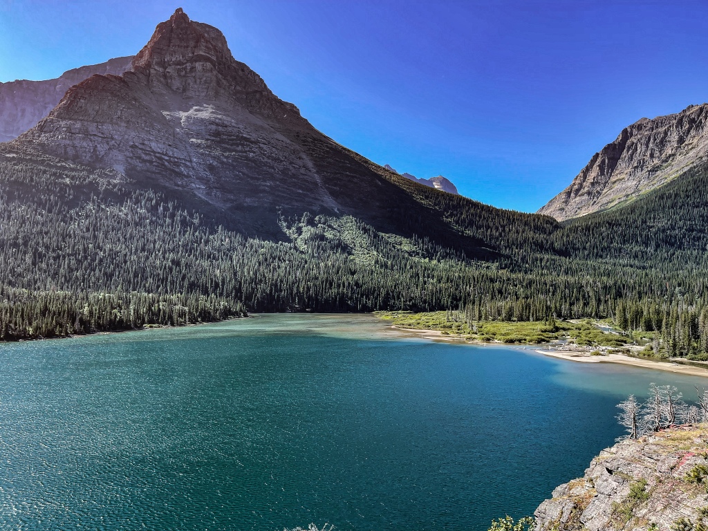
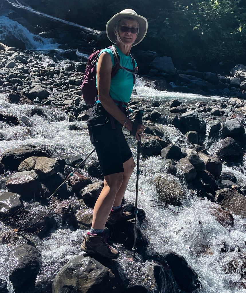
Day-after hike was epic, as well. There is just something magical about this corner of Glacier National Park, and it will be very hard to leave the Two Medicine Lake area tomorrow.
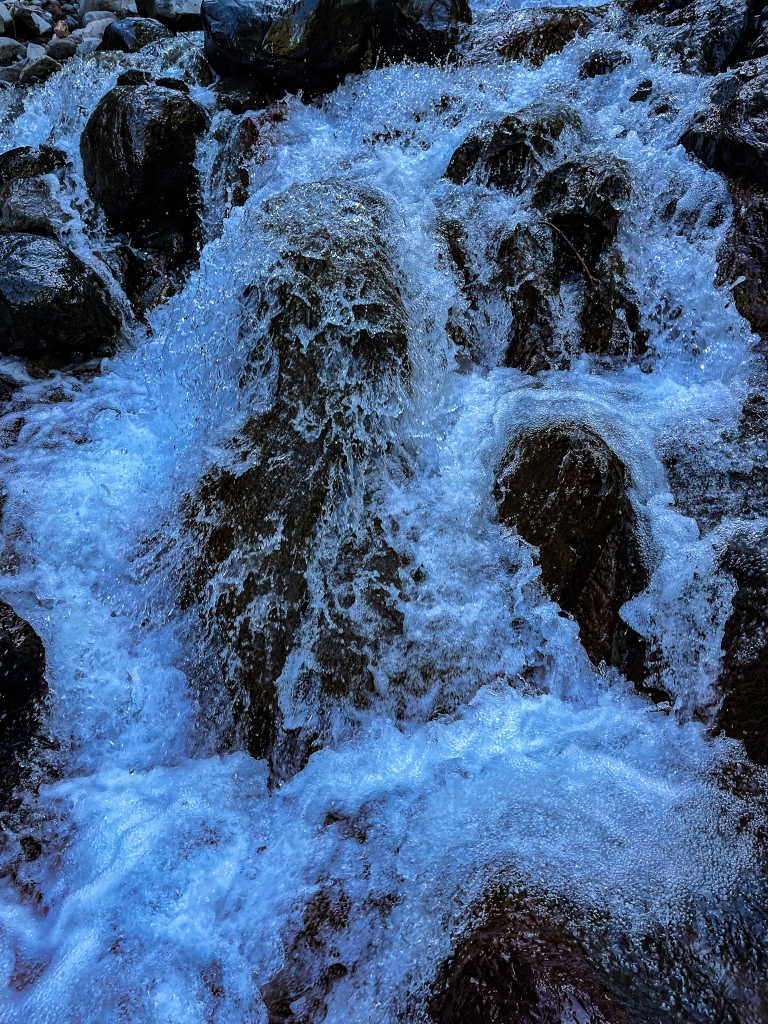
Because George and I are both having issues with sinus headaches lately (forest fire smoke and goldenrod to blame), we thought we’d just take it easy with a short hike or two today. But Aster Point turned out to be all we could ever want. A gentle stroll through a verdant forest to start off, a chance meeting with yet another Bull Moose (!!) on the edge of one of the trail’s many marshes, a 6% grade up a mile to 5,800 feet of elevation, two viewpoints with spectacular waterfalls, and the crowning glory, and a shale-covered bald which gave us a view of five mountains above the tree line!!!!! Four miles of glorious, endorphin-releasing nature with so many ooohs and ahhhhs. Incomparable.
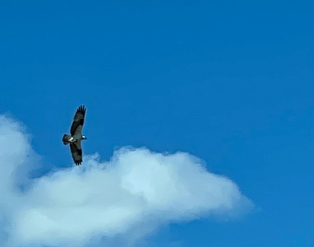
While up at the summit, a gorgeous red-tailed hawk took off just at eye level and we watched it for 5 minutes while it followed the thermals up ever higher to get maximum view of the area. Yes, it was a great day for soaring.
BTW, this hike is not promoted by the Park Service as any great shakes…but we think it’s another one of their well-kept secrets.
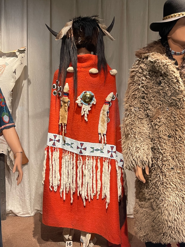
After a quick lunch, we hopped over to the Museum of the Plains Indians in Browning (on the res). It was another very nice regional museum put together by the tribes for public education of their history. Included in the classification of Plains Indians are the Shoshone, Comanche, Kiowa, Arapaho, Atsina, Blackfoot (whose reservation we are on), Cheyenne, Ojibway, Plains Cree, Assiniboine, Crow and Sioux (or Anishinabe) tribes. The museum went to lengths to showcase the traditions, artistic themes, foods, values, history, clothing, tools and hunting heritage they share. We’d never looked at North American tribal history from this shared Plains Indian perspective, so that was very interesting to learn about. We were also pleased to see that the museum was more well-attended than we’d feared it would be.
There are still over 100,000 surviving Plains Indians today, primarily across the Dakotas, Minnesota, Wyoming and Montana, and DNA dates their presence in this area to 13,500 years ago. Browning demonstrates some of the work they are doing communally to preserve their heritage, including a very large Bison Reserve between town and the National Park, a casino/hotel, cultural center, recycling plant, community college and school system.
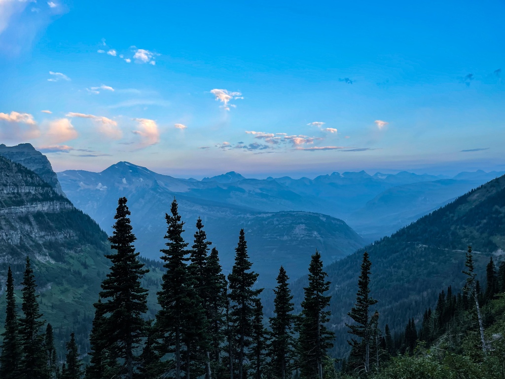
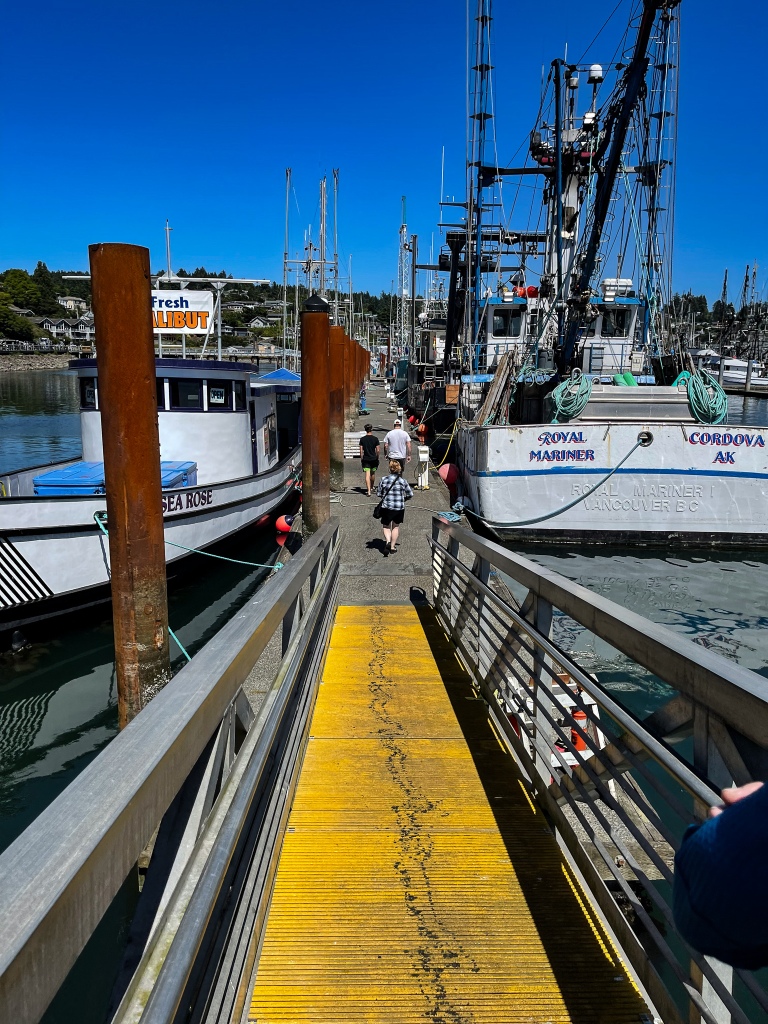
Catching up on the past couple days. We are now in St. Mary’s, which is another Blackfoot village on the edge of the Park. Nice campsite, and very close to drive to our trailheads. We are really loving staying on the east side – much less crowded than the west side, less commercial, with closer access to Logan Pass and Many Glacier’s trailheads.
To start, we renewed our relationship with Siyeh Bend (our favorite trail last year) by hiking up to the split between the Siyeh and Piegan Passes. It was lovely just as before, although we miss summer’s cavalcade of color from the alpine flowers. Siyeh Creek was just gorgeous in the afternoon sun, but because most of the first part of the trail runs through forest and heavily wooded meadows, we did not suffer in the 60-degree sunny exposure. We did verify that we need to be at any of our trailheads in this area before 6am, as parking lots become congested soon after that hour. Also refined our hiking schedule for the rest of our time here.
Today, as per the previous paragraph, we were in the parking lot at Logan Pass at 5:30am, and people were pulling in right and left!! Waited until there was enough light to be able to see where we were putting our feet, and then hoofed it over to the High Line trailhead. Yes, this is the ONE that everyone talks about. It’s a narrow ledge-like footpath for some of its distance, as it floats high above the Going-to-the-Sun Road on the Garden Wall side of the valley. And we were far from alone. Every day in the hiking season hundreds and hundreds of people make this trek, some turn around after a mile, some hike a couple miles, some do what we did (hike to Haystack Butte) and turn around (8 miles RT/~1,000’ elevation gain), some hike all the way to the Granite Park Chalet and beyond (11 miles+). We’re trying to save ourselves for our longest hikes coming up. This version of the High Line was just great.
In spite of COVID, lots of international visitors are hiking in the park this summer (maybe as many as 1 in 5 hikers), both in groups and in families. Also LOTS of college kids. That’s encouraging to see. Makes up for the guy in our campground who said Going-to-the-Sun disappointed him because he couldn’t see any animals from his truck window. For real.
The trail started out with a type of Via Ferrata (hike with chainholds) for the skinniest path along the most treacherous ledge, then it opened up to a slightly wider path that passed small waterfalls and dry gorges, scree fields and spruce forested walkways. It was magical to watch the sky become tinged with sunlight, but still fully possible to see the fire smoke in the far distance. We’ve been luckier than many to miss the worst of the smoke until now. We’ll see how that luck holds for the final four days. Because this trail is so well-watered by springs and creeks, we saw quite a few plants and flowers blooming (including the gorgeous Grass of Parnassus and Blue Alpine Gentian) that have ceased blooming elsewhere. Hence the name of the rock wall alongside hikers the whole way: Garden Wall.
At the turnaround point we opted to hike halfway up Haystack Butte, at least as far as the Hiker’s Path went. From there on it became a Climber’s Path and the going got very steep indeed. We hiked up to the first plateau, investigated the interesting rock formations (marbleized limestone and deeply-etched and eroded mudstone) there, had our energy bars, water and a bit of rest, then hiked back down and returned the way we came. Saw two mule deer does and a fawn on the side of the trail, and the hundreds of hikers just coming out for the day.
On the way back to camp, road traffic got quite slow and finally stopped next to the east end of St. Mary’s Lake. Turns out cars had stopped all over the road for two bear cubs stuck up in a tree. You just never know what you are going to see in the Park! Note: and MOST of the time, you’ve gotta hike to see the critters!!
Two tuckered hikers, Osprey nest in Visitor Center parking lot, two cubs up a tree.
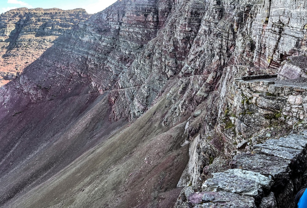
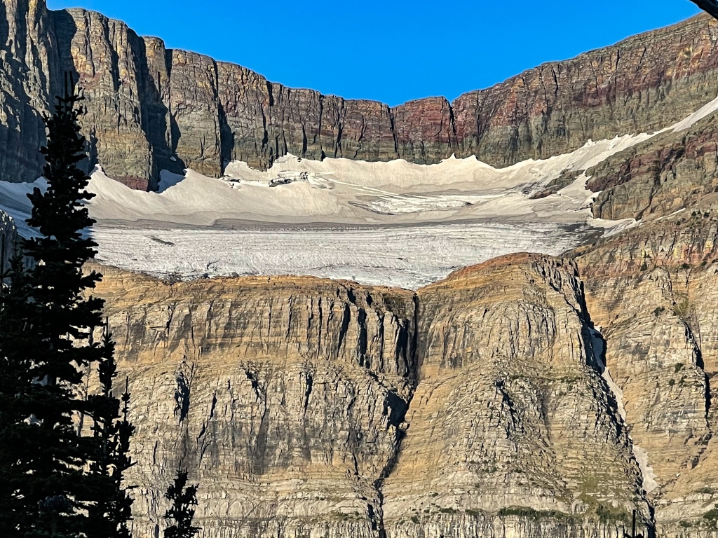
Today was one of our top three EVER hikes: Ptarmigan Tunnel. Readers of this blog know our love of geology, so it won’t surprise you to know that the stunning rocks to be seen on this trail are best-in-class and a major attraction.
Ptarmigan Tunnel Trail is normally a 10-mile hike to and through the tunnel to the other side, where one can view the south end of Elizabeth Lake. But we opted to hike another ¾ mile beyond and was it worth it!!
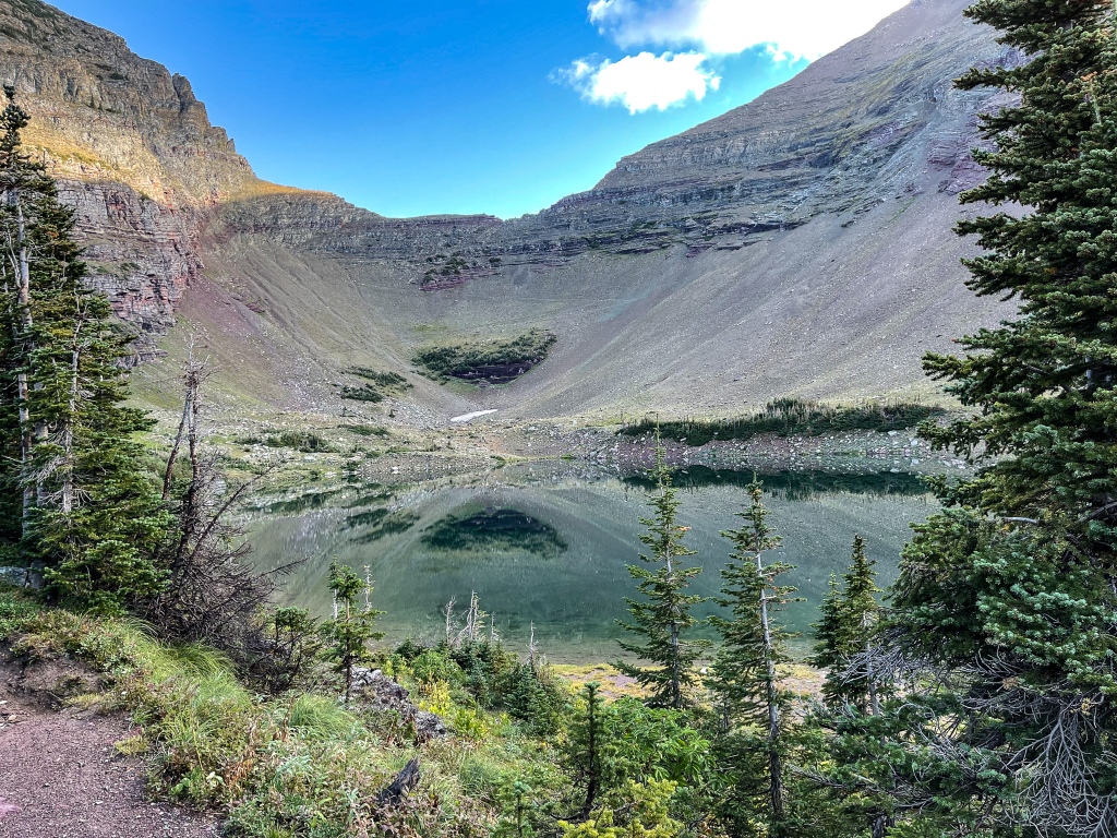
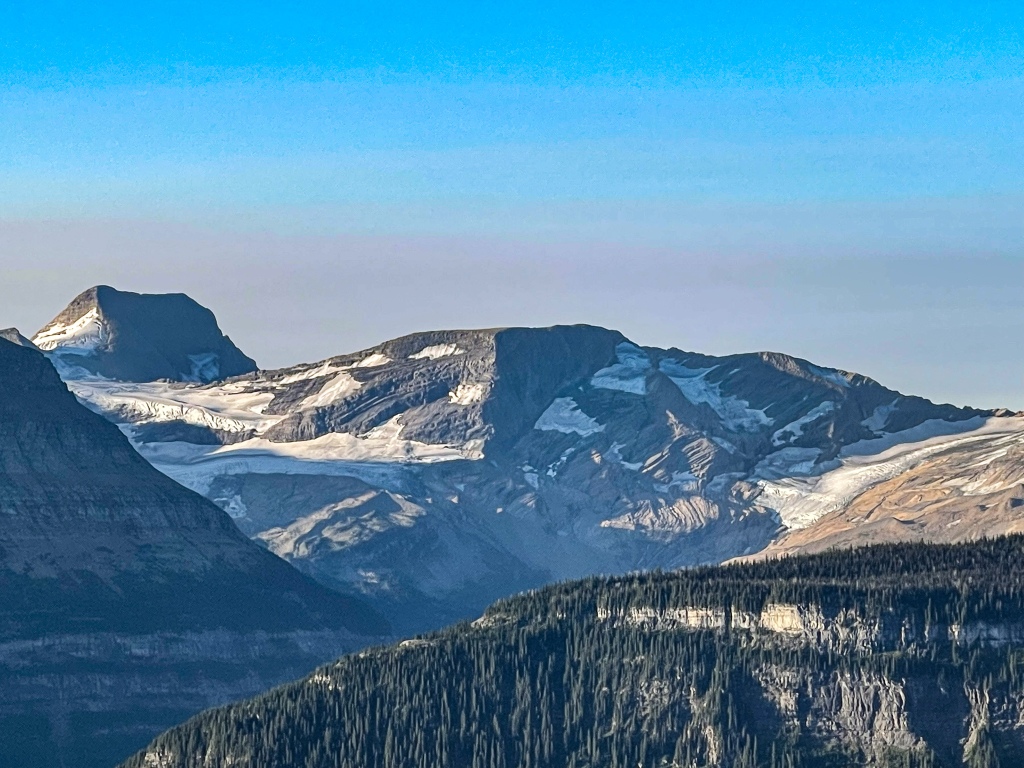
The mountains you see in the first half of this hike are those shared by other well-known hikes of the Many Glacier area: Grinnell Point, Mt Allen, Mt Gould, Crowfeet Mtn and Mt. Wilbur, in the early morning glow of sunrise. Many of these are either glacial horns (deeply carved on three sides, like the Matterhorn) or arêtes, i.e., mountaintops that have been scoured on two sides, so that only a thin crust of vertical rock remains at the top. A browsing moose cow was seen about a mile into the hike. After Ptarmigan Falls and a long, forested stretch, the enormous glacial bowl and steep-sided treeless glacial valley comes into view. At about the 4/5 mark of the trail out, we arrived at Ptarmigan Lake, a melted glacial lake at the bottom of the enormous bowl referred to earlier. It’s deep turquoise green, as are most high-alpine lakes here.
This is where things started to get…unique. Note: some of the mountains in the Many Glacier area of the park contains a beautiful deep red mudstone called Argillite, only found in a few places in the world. And the latter part of the Ptarmigan Tunnel Trail exposes a LOT of it to view. Folded and many-layered sedimentary rock containing argillite is generously on display, and it’s eye-popping, so saturated with color and in places displaying a warm sheen.
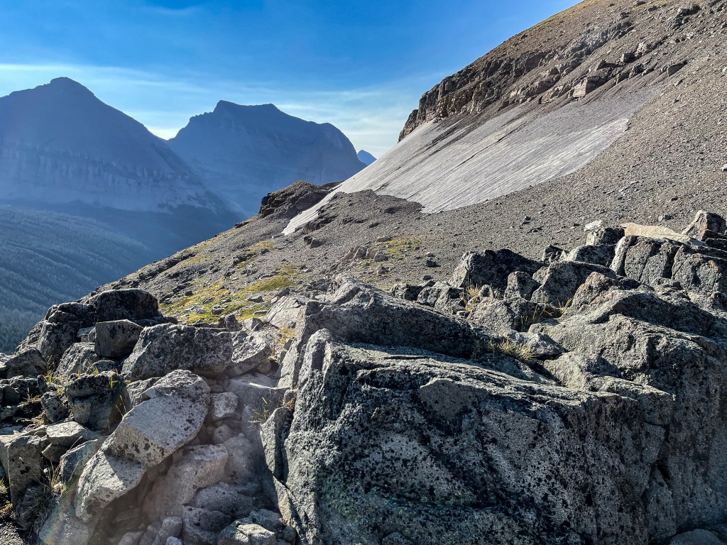
From Ptarmigan Lake to the tunnel (blasted through the mountain wall by the Northern Railroad in 1931), we hiked a series of l-o-n-g switchbacks through a seemingly endless barren scree field, to get up to 7,300’ and the tunnel entrance. The tunnel itself was put in so that the Railroad could enable its guests to ride horses to the next valley, otherwise inaccessible to all but the sturdiest of hiker-climbers. Once hikers are through the tunnel, the view opens to another world, an open and rocky set of slopes that have more in common with Tibet or Afghanistan than with Montana. The Railroad constructed what looked like a Genghis Khan-era stone walkway along these rocky slopes to convey both horse riders and hikers to Lake Elizabeth several thousand feet below. It is a magical Tibetan-like wilderness view that we will not forget. And hiking the ¾ mile beyond the tunnel allowed us to see up yet another valley to the three remnants of Ahern glacier, Mt.Natoas and several hanging valleys above. Sometimes it seems as though the glaciers, mountains, valleys and forests of this place will go on forever! And did I mention that we had the view to ourselves for a good half hour before seeing another living person?
This, then, was our turnaround point. After starting out at 6:45am, we started our descent back to the trailhead at 10:10am. By the time we reached the Lake again (and a perch for lunch), traffic started to pick up and steadily grew all the way down. We had the opportunity to see all of the mountains again, this time in broad daylight. And at the trail’s end (1:30pm) as we strolled from the gravel trail path to the parking lot, we encountered our last wildlife of the hike: a 350-pound grizzly bear teenager! How do I know how much he weighed? Well, he was on his own, and somewhat small by grizzly standards. Young Grizzly teens are kicked out by Mama Bear at 18 months of age, by which time they generally weigh about 350 pounds!! He was confused and disoriented by his trip through the parking lot to get to the next field or forest, and he quickly departed the scene. Great way to wrap up a hike!!
Random facts about Glacier National Park:
Glacier NP was established in 1910, but really developed with the aid of the Great Northern Railroad (owned by James J and Louis Hill, who were Minnesota’s version of gilded era magnate/philanthropists like Andrew Carnegie and John D. Rockefeller). Louis Hill poured money in to help Americans gain access to the park through better roads, etc. Of course, it helped the railroad business thrive, as well. Roads, trails, housing and lodges are all first-rate and numerous. And all still in use today.
Glacier National Park and Waterton Glacier are known as the International Peace Park and the Crown of the Continent, encompassing over 1 million acres of wilderness. Up to now, the park has lost almost none of its plant or wildlife species it’s had since its founding.
GNP is known as a hikers’ park. Over 730 miles of trails. Trails are always in exemplary condition, so clean and well-engineered. A goodly number of back country campers come out for 7 days or more in the wilderness. What a wealth of nature to discover and cherish.
Late summer and early fall, the trails take on a funky smell as vegetation starts to decay everywhere. At first, we thought it was bear scat, but it’s pretty much everywhere, especially on early dew-soaked mornings. Comes with the territory. On the flip side, NO mosquitos, black flies or hornets at this time of year.
You can see wildlife literally anywhere, at any time of day or night (and we have). Your chances are greatest if you get off the road and hike. We’ve seen grizzlies in the parking lot, baby bears and peregrine falcons from the road, and moose (male, female and calf) and Golden Eagles at elevation at numerous times of the day. Slow down, scan the meadows, woods and waters. You’re bound to see critters.
Bears of both varieties (Grizzlies and Blacks) are quite a constant presence in the mountains and river valleys, so rangers advise to always make noise when hiking. We greet them presumptively at every trail turn with chants, sayings and invitations to go about their business without engaging with us. We carry bear spray at the ready and a pocket air horn. And when a bright orange sign appears advising that a trail is closed due to bear danger, we leave it alone. That is ranger code for “Bear has a kill on the trail,” which a bear will defend aggressively. No one should cross that line. UPDATE: one of Glacier’s most popular trails was closed late in our visit due to a black bear getting into campers’ food. It then became habituated to easy pickings in campgrounds and could not be shooed away. This always causes euthanizing of bears and happened in this case.
This area is sacred to the Blackfeet Indians, and they have been here for 13,000 years. Read their stories about the land, mountains, their legends and relationships with the area’s creatures. It is impressive. We have enjoyed our time in their camps (two so far, and we plan to stay at Chewing Black Bones Camp next time we come) and seeing signs showing their language and place names in the area. Hoping to make a Blackfeet pow-wow next trip. We drove through the northernmost territory to reach the Canadian border in the International Peace Park. Plenty of hikes for us to investigate up here next time, and we got to see Chief Mountain on the way, which is the most sacred site in this Indian territory.
Blackfeet place name, two peregrines on the hunt, sacred Chief Mountain, tipi’s much like they would have stood 10,000 years ago, morning light over east Glacier’s peaks
Did a short trail today, St. Mary Falls, Sunrift Gorge and along St. Mary Lake. More gifts from nature included a bright and sunny sky, signs that the lakeshore is recovering from forest fires of 2012 and 2018, a peak at mama moose and calf snacking in a shallow cove of the lake, and some of the prettiest falls and currents in the park.
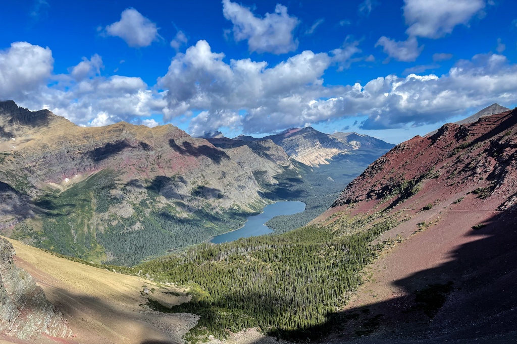
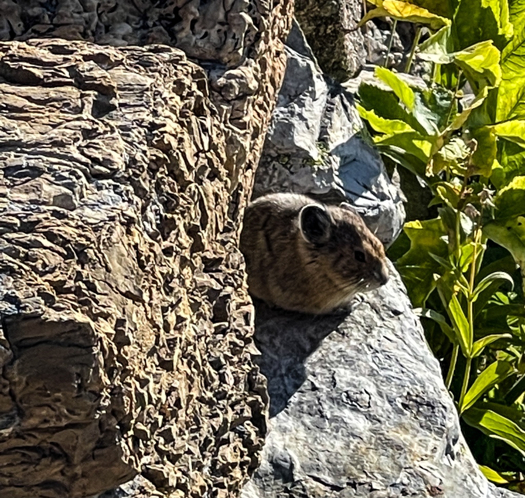
Our last Glacier NP hike was today, and it was another outstanding trail: Piegan Pass. The name comes from the Blackfoot name of one of their sub-tribes, the Pikani. 8.9 miles of glory, half in the spruce forest of Siyeh Bend, and the other half along the scree wall of Cataract Mountain. This was another hike that gave us very long sight lines, back to Going-to-the-Sun Road and Jackson Glacier, as well as along Piegan Mountain and Piegan Glacier. We were accompanied for at least two miles by communities of pikas, chirping as they do. Getting to the pass, a different world opened up against the backside of the Garden Wall we’d hiked along on Highline Trail, showing Morning Eagle Falls and a small turquoise glacial lake (tarn) at the bottom of the bowl at our feet. We could see Mount Gould and the long route that really ambitious hikers take to get all the way to Grinnell Glacier and Many Glacier Hotel.
On the return, we opted to take in a bit more of Siyeh Pass so continued to Preston Park, the wide open, flat and heavily flowered basin at the bottom of Siyeh. We were really thrilled to see a mama Grizzly Bear and Cub 150 yards in the distance, on the scree field of Mahtapi Peak, flipping rocks and big slabs of slate to get at the Army Worm Moths that come to the mountains at this time of year to catch the last flowers’ nectar. Bears know that these moths are tasty and calorie-dense treats, so much so that they make up 1/3 of a bear’s diet in late August-September! Quite a sight!
NOT our picture, but representative of the mama teaching her cub to flip rocks for food.
Almost saw another giant grizzly that other hikers warned us about on the way back down to the trailhead, but apparently, he’d found a berry patch off the trail. As we drove along St. Mary Lake toward home, a gaggle of cars on the road slowed us down enough to see two more enormous male grizzlies feeding on huckleberry bushes, again about 150 yards off the road. This is how park visitors should really encounter the bears.
We will be sad to leave GNP tomorrow but know that we’ll be back very soon for another 50+ miles of hiking in the mountains of this park, one of the best places on earth. Most hikers we’ve encountered have been friendly, very willing to share info on trail delights and dangers, and most people are very respectful of the need to keep to the trails and pack in-pack out all personal effects. There’s the odd lot who litter the trail with dental floss (?!), gum wrappers, orange peels, energy bar wrappers or water bottles. But in the main, visitors have respect for the parks’ trails.
Wish we could say the same for the couple in an old conversion van who dragged a chair that had slipped from its moorings behind their vehicle. (accidentally, we’re sure). It had the potential to throw sparks and ignite a forest fire, so we followed them for 5 miles, honking and flashing our lights. They accelerated to get away from us, so George drew up alongside them and we shouted that they were dragging their belongings and should stop to secure them. Nothing doing. They refused to stop and accelerated again to get away. Are we so scared of each other these days that we’ll risk creating a catastrophe to stay in our bubble? We hope not.
PS we’ve decided to spread out the hikes more than we did on this trip. Ten hikes over 11 days turned out to be a little much, so from now on it will be more like two days hiking, one day off. That’s sustainable.
In Bozeman for our last multi-day stay before home. Drive down I-15 was fantastic, as it went through the Chestnut Valley and into the area around Tower Rock and Devil’s Kitchen. There will be some dandy hikes for us there in the future. The mighty Missouri River is mighty beautiful there.
Stopped at the Montana Museum of the Rockies in Bozeman today for a crash course in how many dinosaur fossils have been found in this state. Montana State University has one of the best Paleontology departments in the world, and they have SO MANY finds of all different types!! It was really fun to see the progression of baby to juvenile to adult skeletons of T Rex and his kin. Also fascinating were the remnants of a teenage dinosaur gang who all perished in quicksand (kids never listen to moms!) and the intact fossil remains of a vegetarian Tenantosaurus who had been hunted by a group of avian Deinonychuses (predecessors of velociraptors) and eaten on the spot. I wish we could teleport my grandson here for a visit.
Bozeman is very reminiscent of another of our favorite mountain valley towns, Durango, CO, and MSU adds diversity, research capabilities and young populations. Then there is the abundant skiing and hiking and river sport. Nice place. We hope it stays that way. This visit was a bit marred by the intensity of fire smoke from the west, but otherwise it was nearly perfect.
Seeing LOTS of Northern Goshawks in eastern Idaho now, as many as three perched on a single irrigation rig. Majestic birds! The stretch from West Yellowstone, MT all the way to Pocatello, ID is pretty much given over to OHV trails and dirt bikes, making the drive a very dusty and hazardous one, as the OHVs scoot across the highway unpredictably. Twin Falls looks like a town we’ll want to return to, as its rocky vantage points and gorgeous coursing of the Snake River through town are spectacular.
Across Nevada now, we’re seeing some of the desert geography we love and appreciate, but the fire smoke gets thicker by the day. Visibility is about 5 miles now, not far enough to see distant mountains in this state’s Basin and Range topography. Nevada probably has more spots that could properly be called Badlands than most western states, but we love the rock and lava formations. Rabbit Brush is fully in bloom, which makes for bright yellow landscapes and probably also accounts for allergies running on full tilt. Nevada still depends greatly on extractive industries for revenue and jobs, so mines are still active and frequently seen on the landscape (just like southern Wyoming).
Had an epic day yesterday, driving straight through Grand Teton and Yellowstone NP’s to get to I-90 in Montana. We expected a few nice views of the mountains in the Tetons, but little to wow us in Yellowstone, as we had no time to get out of the car.
You should never challenge a National Park to a beauty contest. They showed off their best sides. The Tetons in the early morning light were spectacular, and the east side of Yellowstone in her early autumn colors, well, let’s just say that we like that side best now!! Terrific!! Saw a lot of bison, descendants of the herds that have lived here continuously since prehistory. Golden eagles, elk, and lots of shore birds on Yellowstone Lake. Crowds were down significantly (post-Labor Day), and hills were ablaze in reddened huckleberry bushes. We noted that Yellowstone’s grasses are completely nubbed down to the dirt by the elk and bison after such a dry summer season. We hope they can find brush to subsist on in the winter season. We were awed to travel the Lamar Valley, a wide floodplain where the Park Service released a pack of wolves in 1995. These intelligent team players work hard to keep the population of grazing animals down to a sustainable level. We looked but didn’t see any of the famous Druid pack. Plenty of photographers were also glassing the plains and hills for them.
We opted to take Beartooth Pass, since we’re just in the jeep this week instead of Moho + jeep. This is a high-elevation, twisty road famous across the US for its harrowing hairpins, desolate treeless summit and eye-popping views. We’ll be back to hike it, because it’s all that AND great geology. Like a visit to the Moon combined with the wild and treeless slopes of eastern Mount Rainier. A peak experience day!!
We drove through the National Grasslands of the Little Missouri, in North Dakota today. Past the Theodore Roosevelt National Park that we visited three years ago and its painted badlands. It’s as if Sedona has come to some of the layers of sandstone in North Dakota’s hills and hoodoo’s. Beautiful.
Winding down now. Tomorrow we’ll be home. Once again, anxieties around COVID have shortened the trip, and we need to be home to backstop our kids in case remote learning kicks in again. This has been a fantastic and VERY busy, diverse, active adventure. We’ve loved every minute and every stop (well, maybe not the hours of worry we’ve had over whether the Caldor Fire would reach Lake Tahoe, and the burning eyes from smoke). It’s helped us further deepen our love of the mountains in the PNW and Montana, get an appetite for a longer visit in Alaska, build in contingency plans for inevitable natural disasters like forest fires, and appreciate how slowing down helps us see more. We’ll be back to these parts as soon as we can.
One final note: I was forced to visually dehaze the majority of this year’s photos due to forest fire smoke. This results in the sky often looking more dramatically blue than was the case in reality. Not willing to sacrifice the long view, hope you agree!
Thrilled to be back on the road after an eight-month pause for COVID’s third wave and the vaccination period!
We’re in eastern Wyoming, working our way west via Jeep to the Moho, which is stored north of Sacramento.
On I-90 between Gillette and Sheridan, we already see the snow-capped peaks of the Wind River Range in the distance. Wyoming looks surprisingly green in late June, so we suspect they’ve gotten more rain than we have in the drought-stricken upper Midwest this year.
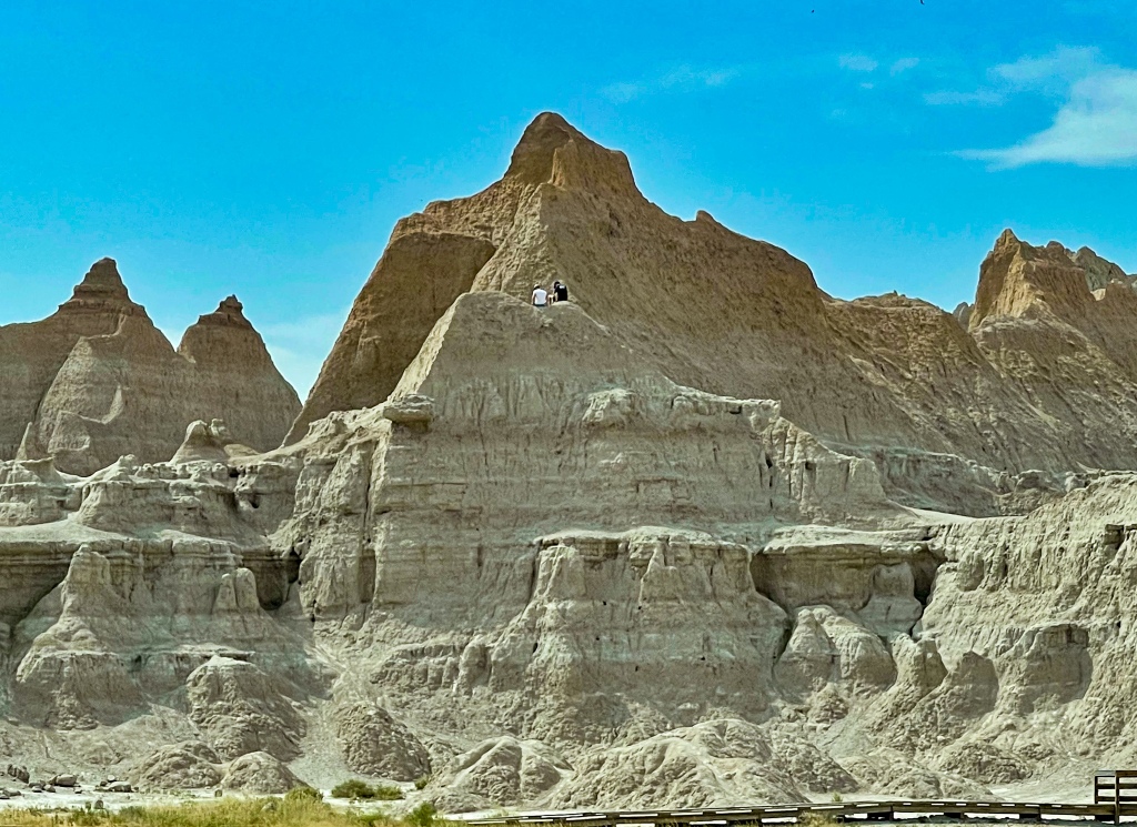
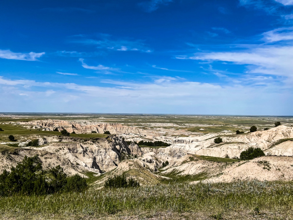
We took a scouting drive through the Badlands NP loop yesterday to renew our knowledge of the sights, as we hope to maybe meet Greta and Dan and the Littles there next year for some fun. Looks as interesting as it did on the first visit 35 years ago. But it was scorching hot this year, so we’ll schedule the trip for a more temperate season, like Fall.
So many eroded hills for kids to scramble on!We could learn a thing or two from bighorn sheep!
Having studied and seen many landforms in the past decade, we now look at northern Wyoming through different eyes. What once appeared bleak and barren is now a storybook of detail on the origin of these rolling hills and eroded slopes. The mind is always busy with geologic diagnosis. Happy to note the sparse traffic on the highways, but we still expect to see hordes in the RV campgrounds and national parks. We’re about 20 days out from flying from Seattle to Anchorage for a 10-day meet-up with the family.
Reminder that Wyoming once was an inland sea.
Today’s 625 miles flew by in a relative hurry. Cutting through Wyoming diagonally, we emerged in Utah and got to Salt Lake City for the night. Two downpours of welcome rain ushered us through the Wasatch Mountain range and into the bowl where the urban SLC population sits. Tomorrow we’ll fly (metaphorically) through the western desert of Utah and Nevada’s basin and range landscapes to finally reach Lincoln, CA and our home on wheels.
In Sacramento it’s like Hell’s kitchen, but what’s hotter than that? Redding, CA, apparently THE hot spot of California, at 113 degrees. And this is where we had planned to spend two days to recover from the long drive. The campground is so lovely, but really, when it’s positively searing hot, we cannot leave the AC of the moho to enjoy it. Leapin’ lizards, it’s hellacious!!!! And this is normal for Redding in mid-summer…some days, it’s 119!!!
From Sacramento up to Redding is one of California’s major nut, rice and fruit tree growing zones. We wonder if these crops can survive long-term in such heat and drought, and even though there’s a town here called Dairyville, it’s not surprising to find that no one has milk cows in these parts anymore. The milking ladies cannot take the heat. UPDATE: news sources reporting that these very farmers are now selling their seasonal water rights to others in neighboring farm areas worse off in the drought. Rights to one acre-foot of water bring $575.00 – allowing rice farmers to earn nearly as much from fallowing their fields as from producing rice. Almond and grape farmers are not so lucky. Some are tearing out their trees and vines to put in solar farms. Things are changing here, in the worst drought year yet.
Three hours to the west is the deliciously temperate Northern California coast, and we’re delighted to arrive to 60-degree temps here! What a difference Pacific breezes over the ocean can make. Drove Trinity Road west across the coastal mountains, a gorgeous highway that threads along the canyon made by the Trinity River. This is paradise for those who fish or river-raft, but almost half of the route was scarred by the Carr Wildfire of 2018, when 229,000 acres burned over 33 days. Underbrush is coming back, but wow, the fire came within feet of many houses and cabins up here.
Redding to just north of McKinleyville: 115 degrees down to 65 degrees!Torched slopesBeautiful from a distance, but this all used to be forested.
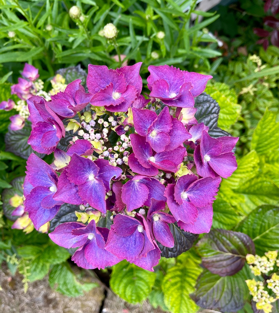
We’re in Trinidad, CA for a day, resting up for Redwoods National Park just to the north. Our first hike came today, and it was pretty darn short because this was a driving day. Two miles along the Rim Trail at Patrick’s Point State Park – just what we needed to get started on getting our hiking legs back. The coastline looks gorgeous, and some of the wild azaleas are still in bloom!!
No, this is not an azalea. Those come later. This is a gorgeous hydrangea!Y’all KNOW how I love remote beaches!!
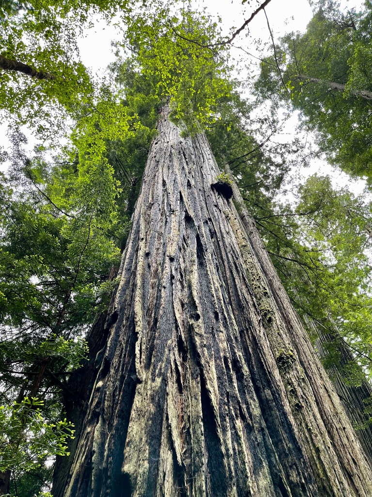
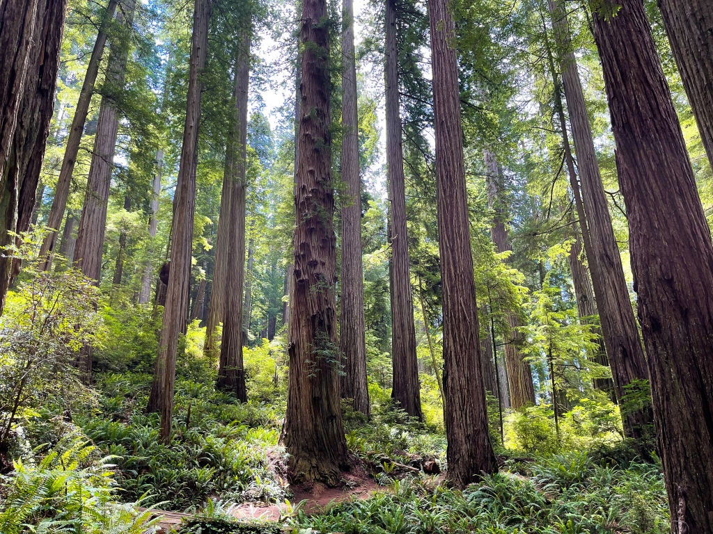
Now in the coastal Redwoods National Park, we find the forests an ethereal mix of the Sequoias’ grandeur and wonder, as well as Olympic National Park’s humid and verdant flora. So glad to be here at last. Only 5% of the once huge range of redwoods is now protected. What were the settlers thinking, to cut down almost 2 million acres of these 2,000-year-old trees in the 1880’s?
First on the docket for hiking today was Trillium Falls at the southern park boundary. It was our first time seeing 15-foot-tall rhododendrons and azalea trees, as well as billions of different and lush ferns ringing the trunks of the Redwoods. These trees grow either in clusters of mother and children trees (the latter called clones), or in freestanding volunteer formation, where each tree stands alone. There is no wind in the Redwood forest, as the Redwoods, hemlocks, Douglas firs and Sitka spruce that also grow here very effectively buffer the air currents. The quiet is glorious, the light subdued, and the footpaths are super-soft and silent, padded with centuries of needle straw.
Redwood National Park is comprised of a South zone (shared with Prairie Creek State Park) and a separate North zone (shared with Jedediah Smith State Park). As luck would have it, the Spring 2021 landslide and road collapse on Hwy 101 is in the middle, causing a MAJOR traffic delay up to two hours whenever visitors want to go from one zone to the other. Thus, we have to plan very carefully when shuttling around via 101 (the only north-south road around). Drove through the one-lane repair zone tonight to pick up some Northern Californian Clam Chowder and Cioppino at Crescent City Seafood, and the remains of the landslide looked very ominous indeed. The fish soups were very tasty and proved a great ending to a 6-mile hiking day.
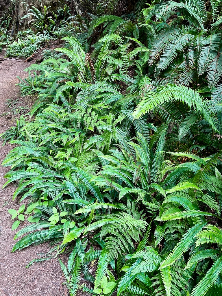
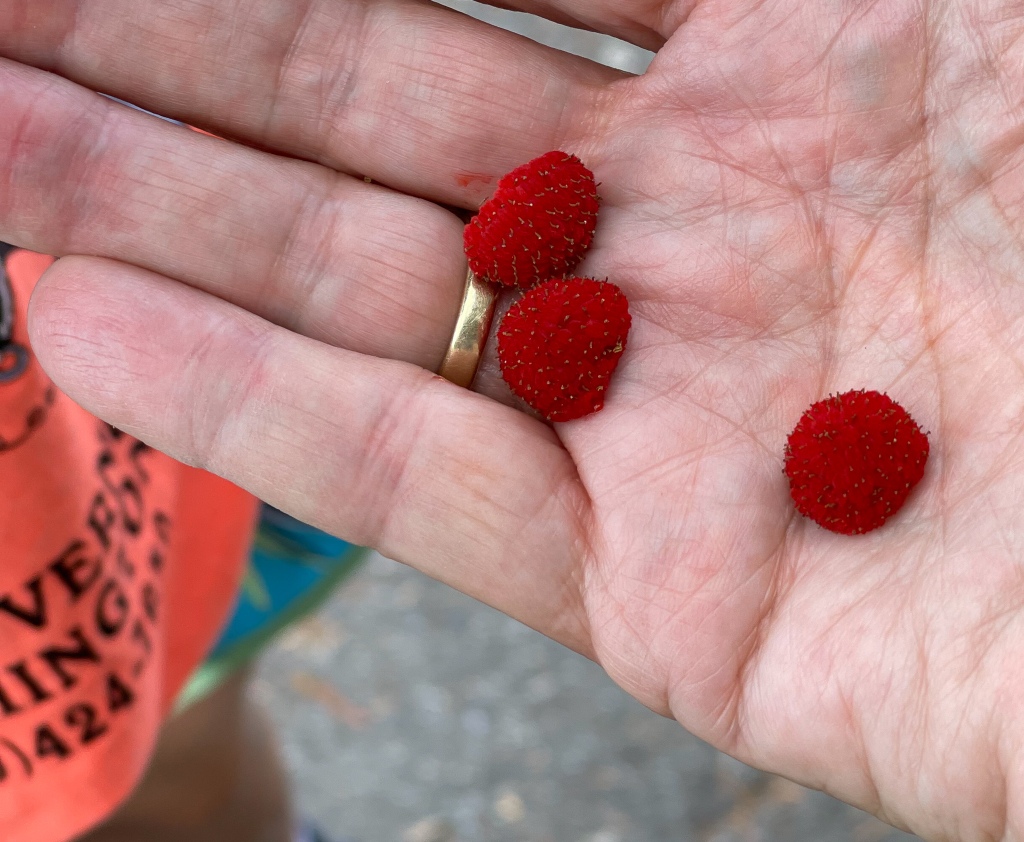
The flora in this park is so beautiful!! 50% of the water available to plants and trees comes from the daily fog, which doesn’t burn off until after noon, so all manner of growing things get big, leafy and well-humidified. Five kinds of ferns are the stars of the scene (next to the Redwoods, of course), but there are also huge Trillium (leaves as big as your hand), 20-foot tall wild Rhododendrons and Azaleas, California Hazelnut, Tanoak, Douglas Iris, Huckleberries, dense Salal bushes and trees, large Shamrocks, Cow Parsnips, bushy Foxglove (invasive!), Monkey Flower, wild Lovage, tiny wild Tiger Lilies, Solomon’s Seal, Bigleaf Maple seedlings, Salmonberries and Thimbleberries (like we saw in Glacier NP and on Newfoundland!) in the forests. On our hike today along part of a ten-miler route, we saw an enormous pile of bear scat, so we know who eats the Cow Parsnips and berries!
The southern zone park has a very popular feature called Fern Canyon. It’s a 7-mile drive to get there, and though the canyon is only a half-mile walk through the bottom, it’s so worth it. The canyon has 50-foot deep, straight, sheer walls that are 100% covered in wet moss and ferns. Breathtaking, smelling like a greenhouse and such a treat to walk through, as there is a burbling stream flowing through it. Birdsong is constant (as are the sounds of children, because the canyon is a favorite among kids and families).
Fern Canyon, trees sprouting from a Redwood nurse log, sumptuous blossoms, and a Redwood sprouting multiple “top trunks.” The largest was found to have 52 top trunks!!!
After another 3.5-mile hike above the canyon, we drove to nearby Gold Bluff beach, which was nearly deserted and blessedly undeveloped. After another 2-mile walk, this time in dark grey basaltic sand, we headed home. Breaking in the hiking legs is progressing well, but we’re totally tuckered for the day.
Yes, I’m rock-hunting!!! But not keeping them in the National Park…
Today we spent our last day in the southern zone of the Redwoods chasing fog, which never really lifted all day. Drove up to Bald Hill Road on the very southeast corner and hiked the prairies and forests of the 120-year-old Dolason Sheep Ranch. The road takes you up above the fog/cloud line, where the sunshine is bright, and temps shoot up from the sea-level 50 degrees to a warmer 70 degrees. Four miles and we were ready for a break, so headed to the bald hills beyond the park, where the highest point for miles can be seen. The US government put a radar station up top in WWII so that it could watch for west coast invasions. The station is still there and visible, but no longer in operation.
We closed out the day with a two-mile hike down near the river, along Cathedral Trail and Foothills Path. Saw the largest and likely oldest Redwood in the park, if not the US. Fifteen hundred years old, 25-foot diameter, 75-foot circumference at the base. Imagine if it wasn’t the only one like it left here!!
Home in the Moho now, we’re baking bread tonight so that George has a low-salt alternative to store bread. Have to keep his heart healthy and happy!
Up in the Northern Redwoods now (Jedediah Smith State Park area), which is a little further inland, but oh, so gorgeous. And we made 6.5 miles/850 elevation gain today, so we’re coming up the curve on hike length and difficulty. Woot-woot!!!
The left side image is actually a bristlecone pine, likely thousands of years old.
Did the ever-popular Boy Scout Tree Trail to Fern Falls, which was like hiking on a wool blanket, so soft was the path. After doing Fern Canyon two days ago, Fern Falls was a letdown, but it wasn’t the falls’ fault. People have climbed all over the rocks and dirt surrounding the water, and they have knocked off and trampled many of the original ferns. Folks are just loving/abusing the National Parks to death. Heartbreaking.
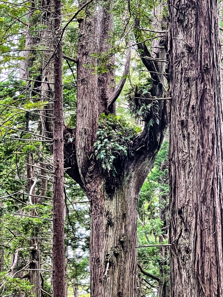
We have a theory about how these colossal trees accomplish their impressive girths. Many of the gargantuans appear to have split tops. Have also read about and seen the presence of gigantic burls growing between closely situated trees (parents and clones). It seems that these sibling and family member trees might actually absorb each other and fuse into one tree over centuries, in order to be stronger together. Then they send up multiple central trunks. One behemoth was recorded as having more than 100 central trunks at its crown!! We’ve seen cross-sections of fallen trees that had to be cut out of a path, and often their insides show smaller diameter slices embedded in the greater mass. As if…what was once separate trees had been enveloped by a larger tree. Fascinating. Botanists call this fusion and flow.
Redwoods are miraculous trees. Insect, blight, rot and fire resistant. Tallest trees on earth (1/3rd taller than Sequoias). Even broken off trees regenerate, producing new growth out of the broken top and trunk. Some branches larger than the next-largest tree. Burls the size of a Honda Civic. Needles light as a feather, but capable of soaking up and giving fog-generated moisture to the trunk equal to ½ of its consumed water. Trunk folds that are 18” deep. Living specimens known to be up to 3,000 years old, still growing at 4″ per year. Intrigued? If you want to fall in love with a tree species, read this gripping and highly informative account written about climbing 350 up in the trees(!) by scientist Richard Preston: http://www.uvm.edu/~jbrown7/envjournalism/redwoods.html.
The northern coast of California is appealingly understated and minimally developed. How wonderful is that? The towns are hard-working non-tourist communities, have been forever, and the land switches back and forth as you drive north between private, public and tribal. The ocean vistas are gloriously wild and accessible from Hwy 101. It’s not a bit shi-shi. It is like the California that time and technology forgot. Love it.
This was our last day in the Redwoods, and we said a very fond farewell to the Giants on the Leiffer-Ellsworth Trail, a memorable 3-miler with more than the usual fire scars on the trees. From our observations, readings and the above article by Richard Preston, we’re convinced of the Fusion and Flow nature of tree growth, as we’ve seen so many trees in all different stages of becoming one big mass tree, and all advanced mergers show burls joining them in the middle. Unfortunately, some of the absorption may leave a void in the center – making the tree more subject to structural weakness and because of a shallow root system, it can topple and shatter coming down. But as noted before, downed wood is quickly colonized or sprouts new trunks, tops and branches. Nothing is wasted in the forest.
Decided to nix the plan to follow on with a hike on the Myrtle Creek Botanical Trail, as four reports last week of aggressive hornet swarms made it sound a lot less desirable. Bears are probably stirring them up, looking for larvae. Always a good idea to check Alltrails.com for trail status.
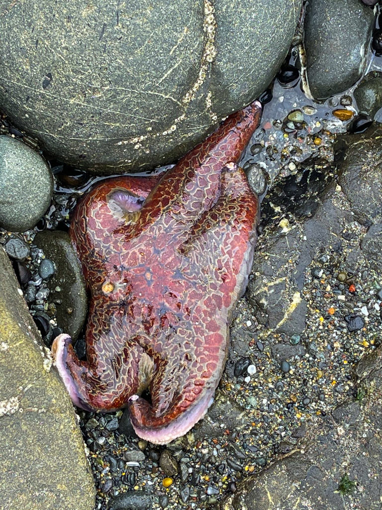
We wanted to investigate the coastal tide pools on the way home, as low tide came at lunchtime today. Stopped at the Crescent Beach viewpoint (where lots of wind-pruned trees predominate) and took the Enderts Beach Trail 270 feet down to water’s edge. Two more miles makes 5 miles for the day. We saw tons of Leather Stars, Mussels, Acorn Barnacles and Green Anemones in the shallow pools. Hoping we can go tide pooling with our granddaughter in about 3 weeks!!
Today’s drive up the OR-CAL coast was interesting in high winds. On the drive, the moho shuddered and involuntarily wandered between lanes as it was buffeted by gusts. Fun.
What was lovely was the scenery – very wild and lots of ocean views. Saw two osprey in flight, one with a snake in its talons. The coastal towns – Port Orford, Brookings, Gold Beach and Bandon – are like what we described in far north California, perhaps a bit more tourism, but not too much. Port Orford looks lovely to come back to, but for the next two days we’re in Bandon. Lots of rocky coastline and seastacks to ogle. The latter are composed of blue schist, which will be so interesting to further investigate in future visits. We love seeing all of the public access points to the ocean, thanks to a 50-year-old law that guarantees Oregonians ample access to love their coastal waters.
Seems the southwest Oregon coast (and OR-CAL zone) are famous for flower and bulb farms. We drove past acres of blooming Easter lilies! On the SW coast, 90% of the plants delivered to retailers in springtime as ready-to-pot white lily bulbs are grown here. There is also a large group of cranberry bogs, enough to make it worthwhile for Ocean Spray to put a processing plant here.
The area is also home to a lot of Salmon fishing on the Rogue River (we saw hundreds of boats in the water at the Gold Beach confluence of the river into the ocean), and both clams and oyster fishing. We tried Butter Clams on the grill tonight, tossed in garlic-lemon-mustard sauce with pasta. Yums.
Today’s adventure was modest, as we had lots of housework back at camp.
Drove to the South Slough National Estuarine Research Area, which is 5,000 acres of land and water that are very important to Oregon’s native flora and fauna. The forests, salt marshes, tide flats and channels are critical habitat for invertebrates, fish, small mammals and many migrating birds. It was a huge surprise to learn that the sub-arctic current coming across the Pacific Ocean splits right at this latitude into current headed to Alaska and current headed to California, delivering a huge upwelling of plankton and other bio-nutrients to hungry mouths in the coastal waters. This is one reason why the area makes for good fishing, also why grey whales, orcas, dolphins, humpbacks, seals and the like populate the coastline, some nearly year around. We didn’t see any marine mammals here, but it’s fascinating to see how the currents and the slough comprise a vital food chain.
We hiked 3.5 miles in the verdant reserve, and it seems to have been greatly restored from destruction done during previous logging eras. Plus, we saw the largest skunk cabbages ever, in the reserve’s freshwater spring beds. Blooming, no less!!
Final note: Face Rock Creamery in Bandon has most excellent ice cream!!
Driving day today, but a couple gems were seen on the way from Bandon to our destination (Waldport) today. One was the miles of Krumholz along Oregon’s stretch of Highway 101 near Waldport: trees and bushes that are kept shorter than normal as the seaspray blows against them. We’ve seen Krumholz on mountaintops, the result of very cold winds and snow/ice that hold growth to a minimum. But “salt-pruning” is a new phenomenon. George wondered if that is where the Japanese idea of Bonsai was born. They are stunningly beautiful here. And the dwarfing makes them look very exotic – like driving through a 20-mile botanical garden.
Another treat was watching the coastline change from sand dunes to volcanic rock to a mixture of both. Always gorgeous.
Finally, we went looking for fresh seafood to put into our jar of prepared Cioppino sauce tonight. Having known about Newport’s cannery row from our last trip here, we returned to visit a couple of fishmongers. The canneries were working today, even though it was Monday of July 4th long weekend. The air was thick with the smell of fish and fish trimmings…. a word to the wise: if you can’t stand the smell, steer away from cannery row!! The odor was heady and brought a substantial realism to what we were in search of. Finally found some beautiful line-caught Ling Cod at a fishing boat converted to a retail shop in the harbor, and local crab/bay scallops at the Fish Peddler retail shop associated with Pacific Seafood Packers. The Bayfront remains commercially active in tuna, crab and salmon packing, as well as retail fish selling and restaurants.
We’re staying in Waldport for its proximity to the town of Yachats (pronounced YAA-hots) and nearby Cape Perpetua, called the Gem of the Oregon Coast. The Cape is a US National Forest property managed by the US Park Service.
On the oceanside you can vividly see the historical basalt flows and columnar seams at the water’s edge, and the intensely rocky shoreline, which make for explosive wave action. The summit of St. Perpetua makes for a gorgeous viewpoint. We did a moderately difficult 5.6 miles today by summitting the Saint, for a total of 800 feet of altitude gain, as well as seeing all the blowhole features at the oceanside. This is the shoreline Captain James Cook spotted and mapped when cruising along the west coast of Oregon in 1776. As so often happens on the OR coast, today started out sunny, then heavy fog rolled in and we got rained on as the fog condensed. Trails were still crowded after the July 4 holiday, but we still got our fill of the misty forest and foggy coastline. Surf noise was just like thunder – what’s better?! Lovely day.
Out at the Tillamook Head today, in Ecola State Park, on the northern end of Cannon Beach on the coast. It couldn’t be a nicer spot to vacation (if you have money). All Cape Cod shingled houses and toney shops and restaurants. The nice part is that every residential street ending at the seashore allows public access to the beach. But Oregon state law mandates this, so it’s true basically in every community here.
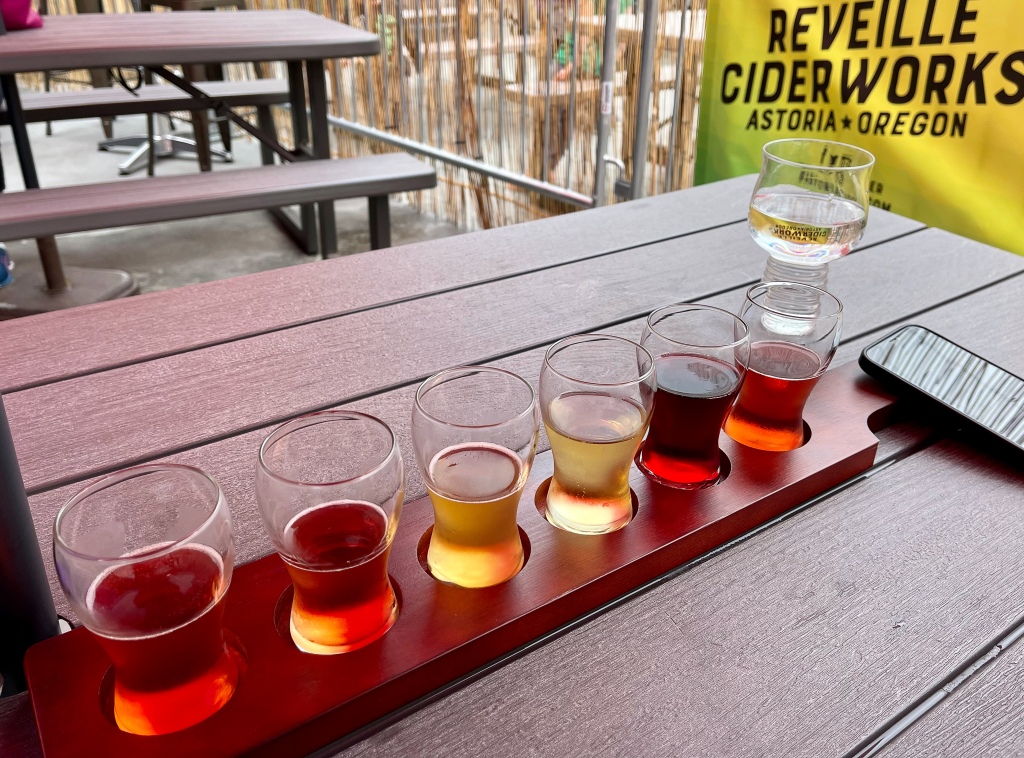
Hiking in Ecola park was quite nice. Lots of sea stacks visible from the coast, signs indicating puffins nesting along the coast (we did not see them), and we did 2.6 miles through forest and up to viewpoints. Typical Oregon fog on the shore again today until after noon. One has to drive into town to see the Haystack Rock, which is 500 feet tall and shaped like a 19th-century loose haystack. After hiking we headed up to Astoria, another wonderful seaside town that reminds us of Portland. Had a tasty flight of ciders at Reveille Ciderworks in town.
Our last day in Oregon was spent at Fort Stevens, the northernmost point on the Oregon coast and, as it turned out, a strategically critical point on the Columbia River. We only hiked a mile along the beach, as there was extensive construction there (reinforcement with huge jetty rocks) to shore up the coastline. We later found out why when visiting the Columbia River Maritime Museum (CRMM).
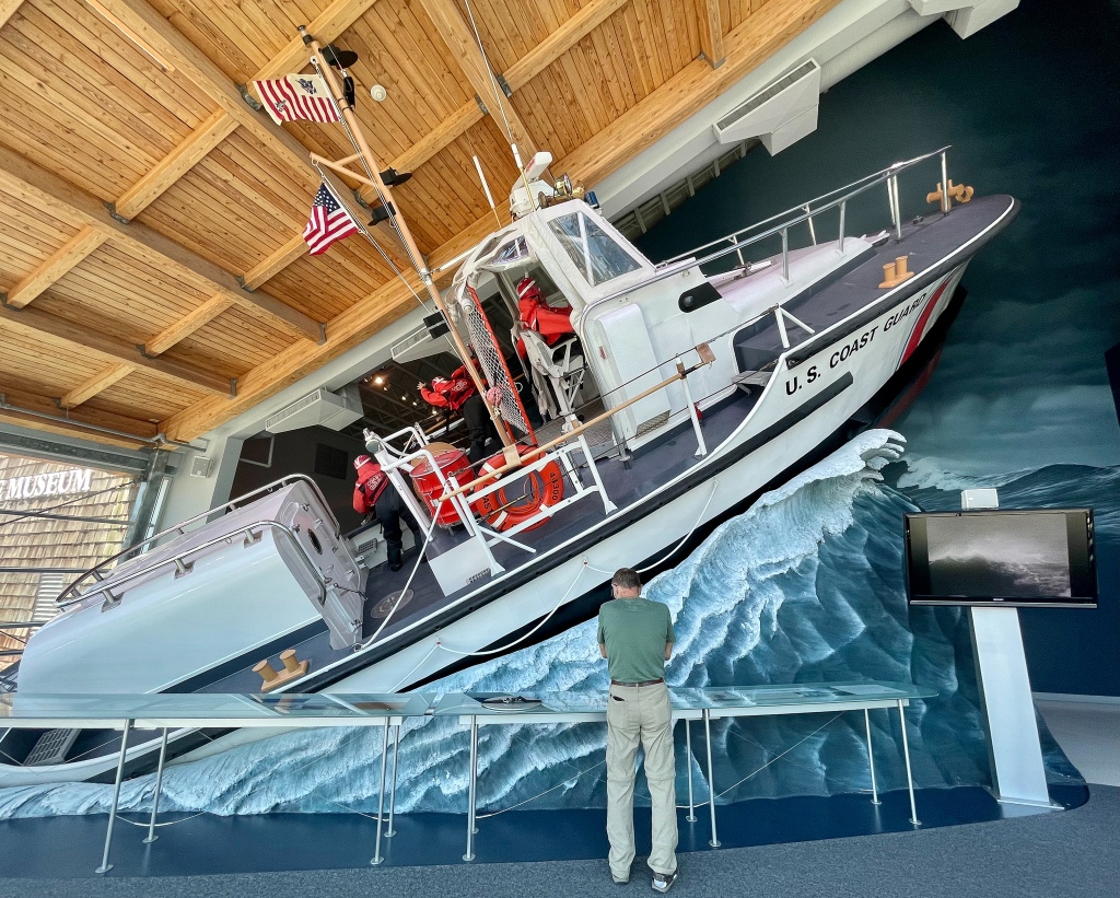
After a quick lunch in the company of gulls and geese feeding on tidal flora and fauna, we drove back to Astoria for the museum. At the entrance we photographed an impressive Coast Guard cutter, which has been responsible for interdicting 1.6 million pounds of cocaine along the northern coast.
Inside the CRMM, they explained that Astoria had been named for John Jacob Astor, who financed and then profited from a highly lucrative trade in fur seal and otter pelts to Asia. Over time Astoria became a large ship-building center for the Pacific NW, as well as the second largest PNW port of entry for Asian import ships from Asia and South America. The museum has excellent exhibits on the very difficult and dangerous job of the Coast Guard in keeping the waterway safe and rescuing ships in distress, of which there are plenty.
The Columbia River delta is reputedly THE most dangerous river mouth/port in the world to navigate, due to the winds and storms coming in from Pacific currents, the flow of the river as it meets the tides, and what is called THE BAR, a shifting sediment and silt bar at the river mouth which can produce up to 50 – 75’ waves under storm conditions! Presumably the reasons for the rock reinforcements we saw at the state park shoreline are to prevent further accumulation of sand and silt and to stabilize the land, as well as increase the water flow speed through the narrow opening, thus keeping open the shipping lanes.
It’s a credit to the town of Astoria that it did not economically crater and become a shadow of its former self after the 1910-1940 glory days. Shipbuilding is long gone, but the community has wisely protected its landmark structures and pivoted to tourism. There are more breweries, tap rooms, restaurants and fun things to do here than you can shake a stick at.
Westport, WA (where we are for two days) must be one of the most popular deep sea fishing charter ports in Washington. So many boats are available to go out and fish for Salmon, Halibut, Ling Cod, Tuna, Rock Fish and more. Hundreds of people are in town, and the waterfront is very busy with folks who didn’t come for the beach. As it turns out, the beach is dark basalt sand and it looks pretty industrial, but there are some lovely stones to collect while out walking. We don’t mind if other visitors didn’t come for this! And wow, is it windy out here. Must be why there are kite shops in town.
Along the way here from Oregon, we passed over the high Astoria-Megler trestle bridge, and from this vantage point you can see the infamous BAR, mentioned in yesterday’s post.
It’s enormous and forces all freighters who need the 40 – 50’ draft into a narrow shipping lane. As you drive up the coastline, you see the many salt flats and wetlands/sloughs revealed at low tide. You also see the full range of local economies the villages and towns depend upon, be it lumbering (Weyerhaeuser has huge tracts out here), fishing (an occupation only 20,000+ years old here), tourism or a combo thereof. It’s not fancy out here, which is just fine by us. Plenty of Oyster processing plants here, and the gulls are quite fond of landing on the shell piles and picking out the Oyster bits stuck in the shells after the packers are done.
Scenic, colorful sunsets and sunrises are a most challenging phenomenon out here. Cloud banks predominate in the morning and evening, and they just don’t lend themselves to much in the way of intense hues…unless you get breakage in the cloud banks. We were a little disappointed the first night here, we’ll see what tomorrow night brings.
——————————————————————–
Today’s walk/hike was along the southwest coast of the peninsula, and it was lovely, but again, very windy. Hiked out to the jetty via the raised dike path, back from the jetty via the beach, much nicer than yesterday’s beach. It was great fun to see dozens of surfers assembled at the water on a Sunday morning, in wetsuits, waiting for surf to come up. Surprisingly, Pacific Ocean water here in the bays is its coldest in the summer, as the deep ocean upwelling is at max right now. Surfers sure looked chilled. One serious athlete had exactly the right idea: get out with an inflatable air wing to do some sailboarding atop a hydrofoil surfboard. He got out beyond the breakers and had a wild airborne ride, to the delight and envy of all others. Of course, the cost of such equipment can get up into the $12,000 – $15,000 range. Not for the casual weekend athlete.
Also walked another estuary path in the John’s River area. Not as many birds in the weeds, reeds and bushes as we’d hoped, but did hear and see some lovely herons and swallows. One swallow mother had built her nest inside the birdwatching blind we entered…. we got a quick look at two baby swallows before scooting out of the blind so her feeding cycle and peace of mind could resume. And we were rewarded by a beautiful setting sun.
After a VERY long hiatus from writing posts, we’re now back to telling the adventure story, after 10 days in Alaska and two weeks with our granddaughter in Western Washington. We will return to near-daily posts from now on, but first, the highlights of the past three weeks:
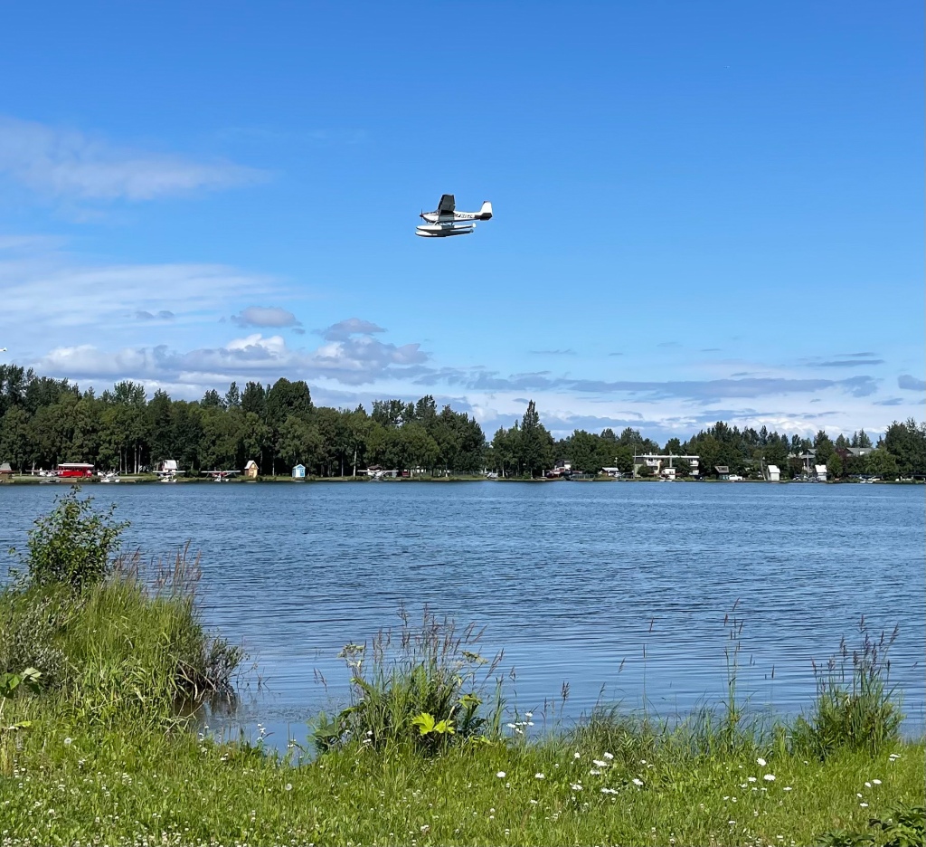
Due to Covid and the interborder travel restrictions between Canada and the US, the AK segment had to be a fly-in meet-up for all. Ten too-brief days to do justice to Alaska, but we took what we could get. Our first stop was at an airport hotel close to the Sound in Anchorage. The hotel was located on the world’s-largest floatplane lake, which is home to 1,800 floatplanes and small aircraft, with 200 takeoffs and landings daily – great fun to observe as flying and flightseeing is a way of life in AK.
We managed to fit in one hike near Eklutna Lake before picking up the kids at Ted Stevens Airport, then we briefly toured Anchorage before setting off for Denali. Not a bad entry into the local way of life.
Anchorage is unlike other moderate metro areas in that it seems like 500 quirky neighborhoods strung together without much updating since the 1970’s. But instead of looking dated, it has a charming personality that we liked. Nearly 2,000 moose living within the city boundaries can’t be wrong, right? We walked the streets, visited a candy factory, took a lovely Grey Tour of the city and had a couple of good meals. This helped us acclimatize to the time zone and the uniqueness of life on the edge of wilderness.AND we saw 5 of the 2,000 resident moose in back yards and along the freeway while on tour!
Once we got out into the countryside, AK looked vast, primeval and unpeopled. Travelled three hours northward up Hwy. 1, which put us at the Denali Creekside hotel outside the national park for some stone-hunting and water fun for the Littles.
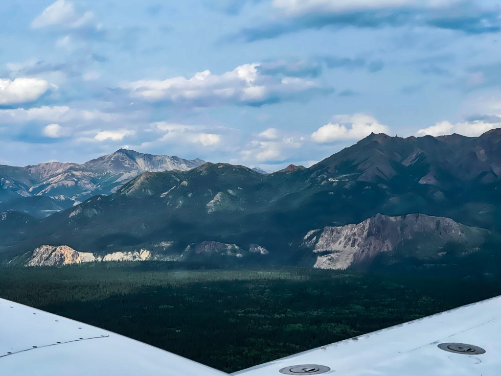
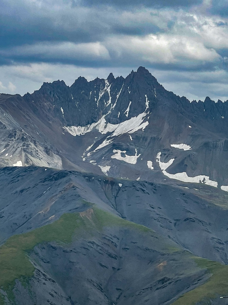
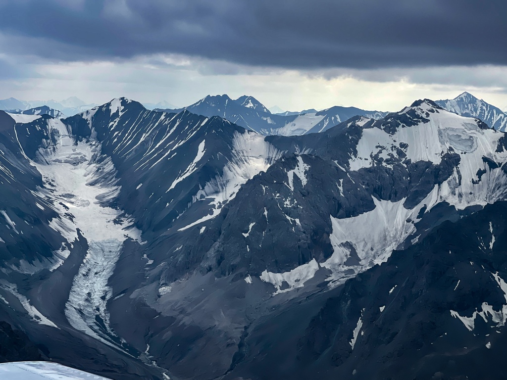
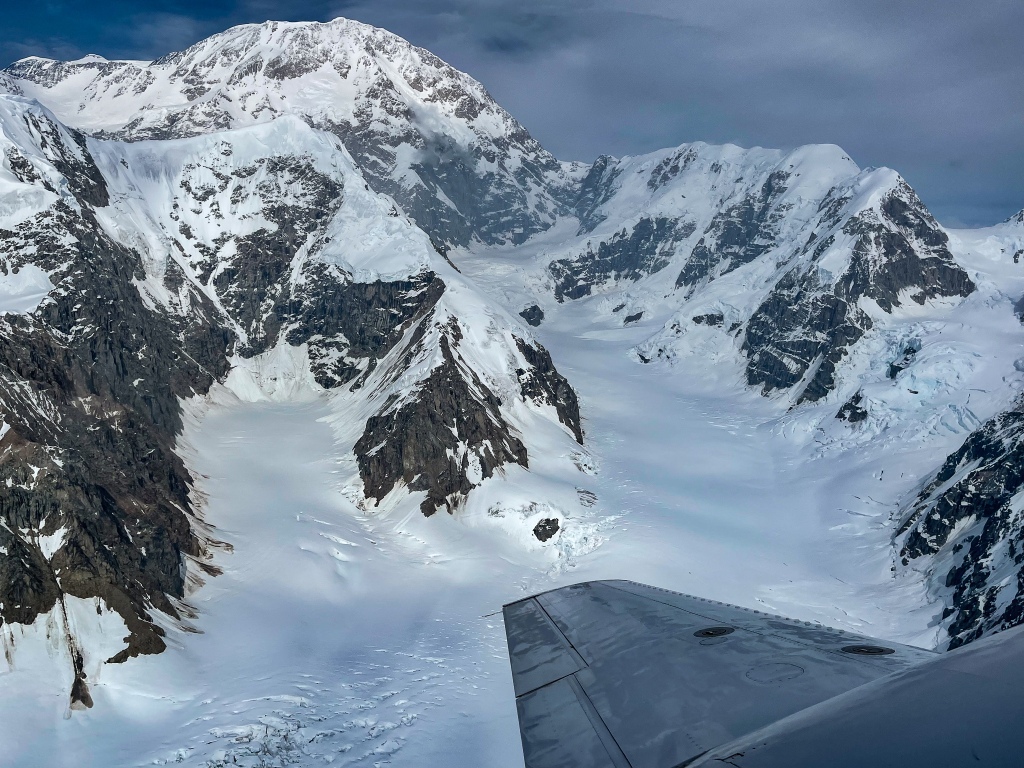
We splurged for a 90-minute, 10-seater flight over the peak elevations at the Denali massif. A combination thrilling and terrifying ride into the realm of permanent winter, the flight took us up to the close perimeter of 20,000-foot Denali summit amid a mixture of thick clouds and brilliant sun as the plane skirted over ridges, up canyons, across some of Denali’s 400 glaciers and along the endless vertical wall of the northern range. It’s a terrific adventure if you can cobble together the steep fare, and we’re so glad we did it. It’s also the only way our group could have beheld the geologic vastness, the length of the still-intact glaciers, the many peaks making up the massif, and the beautiful and brutal wildness of the park’s most commanding feature. For those curious about what you actually see, our pilot took us over Polychrome Pass and the braided Toklat River, then over Mount Mather and the Brooks Glacier, Mount Silverthrone, the East, South and West Buttresses of Denali itself, around Denali’s longest glacier, the Kahiltna, within 1 mile of the highest point, to Peters’ Basin and the Wickersham Wall, Pioneer Ridge and Mt. Kovna, then back down pretty much the way we came up.
Ethereal views of the range
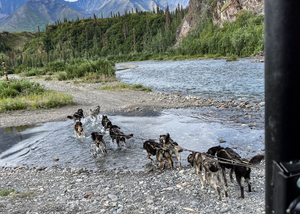
Next day the kids (adults) took the 8-hour bus ride into the heart of the park, to see the wildlife and terrain that is observable at ground level along Denali’s only road. From a long distance away, they got to see a grizzly, a caribou grouping and lots of beautiful scenery. We took the Littles to a local Iditarod musher’s summer retreat for a pseudo-sled dog ride (OHV in neutral gear, hauled behind 12 dogs wildly enthusiastic to be back on the trail). Temperatures were in the mid-60’s, but the dogs were so hot that they gladly laid down in the brutally icy river waters to cool down. Musher Rick had named his dogs after rock and jazz immortals, and Coltrane was his lead dog. They’d been trained to interact in a friendly manner with visitors, unlike other sled dogs we’ve seen.
The net: two days near Denali is only enough to whet the appetite. We will be back.
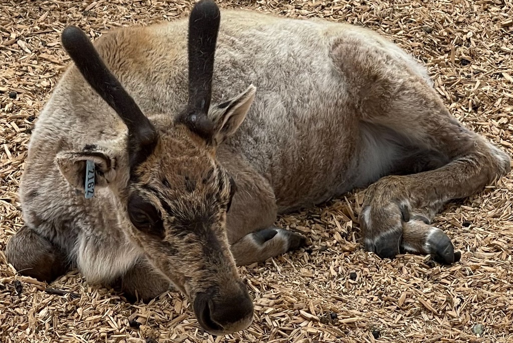
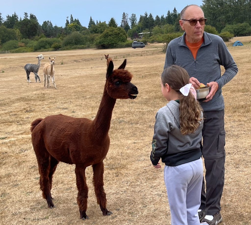
Next stop on this trip was Palmer (a little north of Anchorage) and Girdwood. The highlight of Palmer was visiting a reindeer farm which also housed moose, yaks, alpacas, elk, and apparently most importantly to the Littles, kittens. It was the only way we could get to see a good portion of the wildlife Alaska is famous for, and the animals looked well cared for.
In Girdwood we took the gondola to the top of 2,300-foot Mt. Alyeska and then hiked down, with one grandchild racing and jumping all the way to the bottom, while the other grandchild gingerly, methodically, and slowly worked her way down to sea level.
A drive to our scheduled Portage Glacier sightseeing boat capped off that day, with views of the rapidly retreating Portage ice field and the Norse fiord-like lake it has left behind. Moses, one of the tour guides and a member 0f the Inupiaq tribe, showed off a walrus tusk his uncle recently secured during a hunt up on the Arctic Ocean.
The final day in Girdwood brought a surprising, enthusiastic expression of interest from our granddaughter, who wanted to fish for salmon with the gear provided by our cabin owner. George gave her a beginner set of lessons on fishing lures, casting, how to use a bobber, how to set the hook in the fish’s mouth, how to play out the line, etc. She could probably have fished all day, but unfortunately, she didn’t land anything because the salmon running at this time of year have only one thing on their minds, and it’s not eating!! A generous fellow fisherman gave her a small salmon he’d snagged (legal in some rivers at some times of the year), and we had it that night for dinner.
Seward came next, with its coastal coolness and wealth of natural attractions. We were happy to have landed a whole house as lodging to spread out in, and the Littles delighted in the joys of yet another shallow, glacially fed stream in their back yard. At least in Alaska, the glacier waters are not being fed this summer with quite the torrential volumes occurring in Washington, Montana and British Columbia. They can fill endless hours by playing with river rocks, skipping them and rerouting tiny rapids by building walls in the frigid streams.
Fate had introduced us to a very outgoing and generous young local cruise captain (Tanner R.) while we ate at a shared table in Anchorage, and he became a new great friend who took it as his personal mission to help us have a GREAT time on the Kenai Peninsula. He recommended the best stops for Seward and its neighboring communities, and we now have a full stock of good stuff to see for our next trip to AK. He even brought us a small moose steak to cook, so that our son-in-law and granddaughter could taste it. Moose is not legally permitted for sale in restaurants or markets in Alaska (contrary to Newfoundland), so you have to be or know a local hunter to taste it. Tanner to the rescue!! He also captains Major Maritime sightseeing cruises out of Seward, and although he wasn’t on schedule for the Thursday afternoon wildlife expedition we’d booked, he thoughtfully arranged for our grandchildren to receive a trove of snacks and stuffed animals (sea otter and humpback whale toys) while we were on board. Everyone needs a Tanner, and we all need to be a bit more like Tanner to each other, we think.
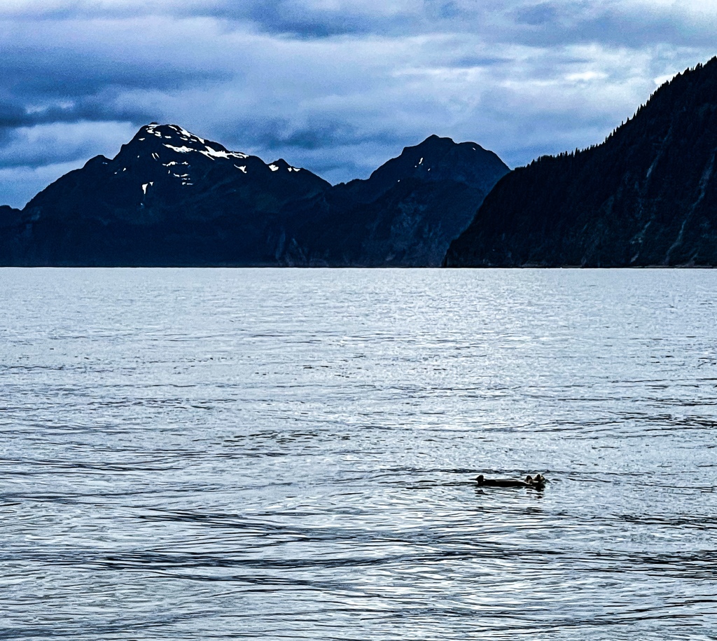
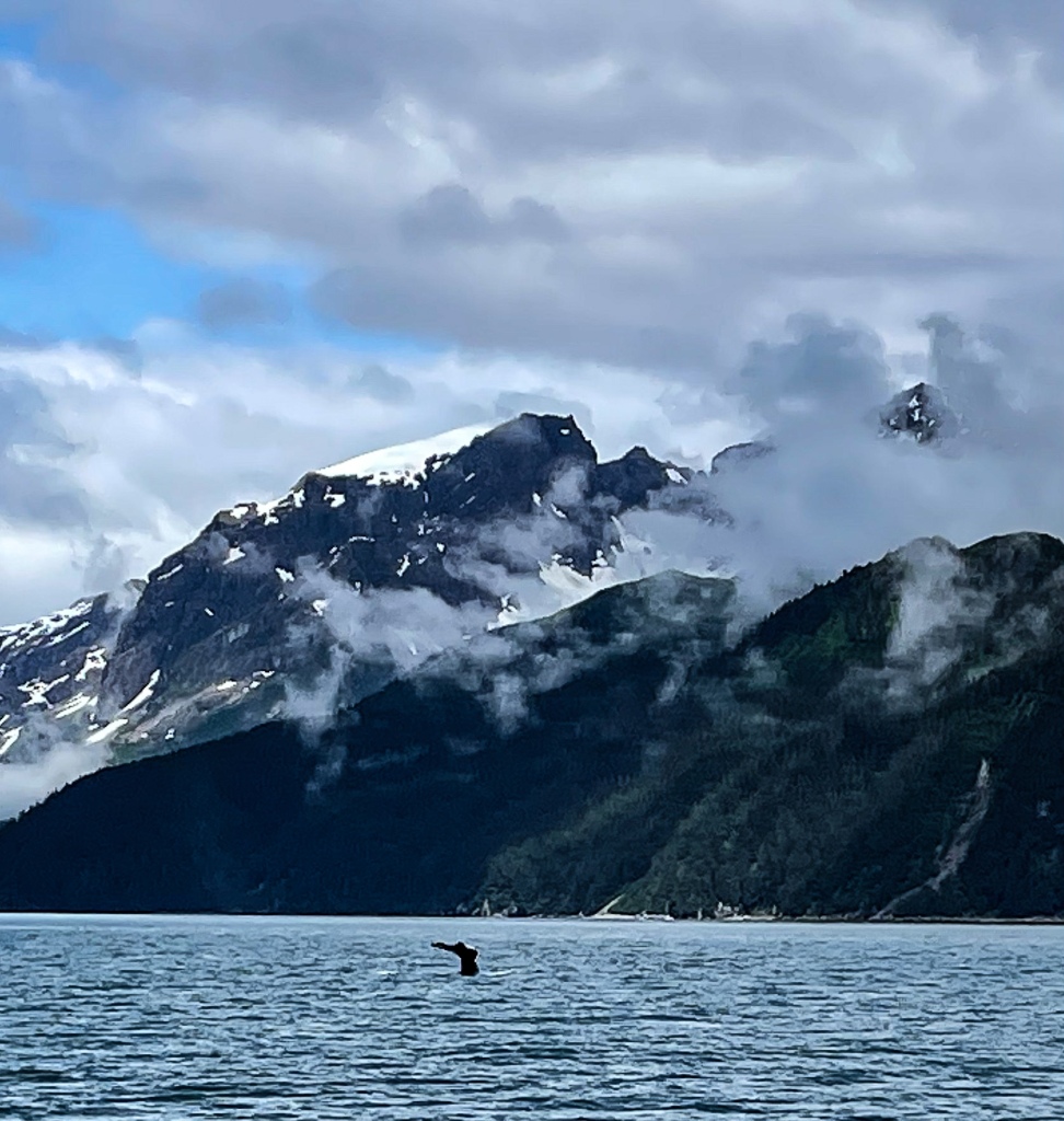
The 3.5-hour ocean tour south from Seward to the end of Resurrection Bay (just before the bay empties out into the Gulf of Alaska) was glorious. Great weather and sight lines on board were superb. The cruise ship held perhaps 60 guests, and everyone had either a booth with a window view or seats up top to catch the wind and the open-air views. We saw a humpback whale surfacing, had 6-8 sightings of orcas, a few harbor seals, many stellar sea lions, several sea otters, a jellyfish bloom (mating swarm) and many, many seabirds. A wonderful, memorable voyage.
Final AK excursions included a drive to see Exit Glacier (lovely but sad, as are all visits to shrinking glaciers).
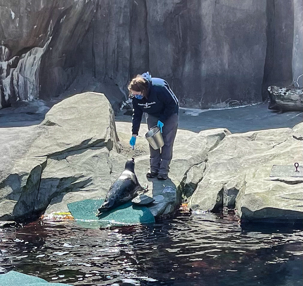
A trip to the Alaskan Sea Life Center gave us a look at some species we hadn’t seen on any tour.
We also drove to the Russian River Trail, reputed to be one of the best places to observe bears fishing amid the salmon runs. In Alaska it helps to know which salmon runs will be on while you are visiting. Whether Coho, Chinook, King or Sockeye, you will either see a whole lot of action or none at all, depending on whether the balls of migrating fish are thick or sparse. The day of our drive/hike, migrating fish were thin but that didn’t stop the hundreds of fishing enthusiasts, both snaggers and fly anglers, from populating the stream banks. It was sort of a carnival atmosphere as both locals and pandemic refugees from the Lower 48 crowded the road and the banks of the Russian River and Kenai Lake. What can one expect when Princess Cruises and Orvis have large stores and a lodge up here? So much for the wilds of Alaska. As a parting celebration, we had a lovely dinner at the Cooper Landing Kenai Princess Lodge and everyone flew out next day, our daughter/son-in-law and grandson to MN and we back to Seattle with our granddaughter.
Russian and Kenai Rivers come together, melding blue and grey meltwaters. Gorgeous lakes and rivers in the area around Cooper Landing, Moose Pass and the entire Turnagain Arm. Eagles are smart to linger near the #1 salmon fishing spot in the world.
On to the northwestern side of Washington state with our granddaughter! After a red-eye flight to Seattle and a half-day nap to catch up, we started a short stay way up at Mt Vernon (close to Bellingham and the Canadian border), which is where the motor home had been stored during the AK trip. Highlights: horseback riding in the mountains with Lang’s Horse and Pony Farm, starting to read Marguerite Henry’s pony books at night, going for fresh apple cider and ice cream in town!
Then off to the town of Anacortes on Fidalgo Island, for another whale-watching tour and some hiking. The Blackfish cruise down Rosario Straights was pretty exclusively just orca-sightings and seemed to deepen our granddaughter’s love for the ocean and getting out on the water. We now have a much better appreciation of the San Juan Islands now, and how easy it is to get between them via the WA ferry system. Hiked Fidalgo’s Cap Sante Park to the summit and loved the view of Mt. Baker and Padilla Bay from there. Sugar Loaf Mountain was a nice granddaughter-challenging trail, as well. We talked a lot about living things we never see at home (thimbleberries, acres of wild blackberries, marsh and beach grasses, gigantic wild rosebushes, kelp, shellfish, and birds that live in the estuaries and tidal flats).
We also wanted our granddaughter to get a glimpse of several different physical environments (mtns, ocean beaches, sloughs, etc) that she cannot see at home, so next we scooted onto the Whidbey Island-to-Port Townsend ferry to get to Washington’s Olympic Peninsula for a couple of days. Turned out to be a visit full of surprises, as we stayed on an Alpaca Farm in Port Angeles (!), beachcombed the rocky/sandy Juan de Fuca Straights beaches, attended a dog show to watch our kids’ beloved French Bulldog breed competing at a local dog show, and did u-pick lavender in Sequim, as well as a short hike up Hurricane Ridge in Olympic National Park. All activities hugely enjoyed by the entire crew!
The final nature encounter required a long drive from Port Angeles down to Aberdeen and Long Beach on the sw Washington Pacific Coast. Weather was much cooler and mistier out here, and it was not the greatest environment for building sandcastles on the beach, so instead we learned about algae, jellyfish, tidepools and sea smells (some lovely, some not-so-lovely), the glories of kite-flying on hard-packed sand, and the fish-packing and native communities that live along the Pacific Ocean and Gray’s Harbor. And then there was the 90-minute horseback ride on the beach, complete with trotting in the sand and surf!!!! A peak experience, for sure!!
The last couple of grandparent-grandchild adventure days were spent in the metro Seattle area. Our granddaughter missed the one and only trip we’d made with our daughter & family two years ago, but had heard about it ad infinitum, and she wanted in on the fun. So, we took in the neighborhoods, toy stores, Pike Place market and surroundings (including animated buskers, of course), as well as a tour of the Seattle Chocolate Factory, and a welcome swim in the campground pool. All too soon our time was over, and George escorted her via Delta Airlines home to Minneapolis, then flew back to meet me at the campground. What a GREAT time, and now we have lots of ideas about how to improve on touring with Grands for the next time out!!!
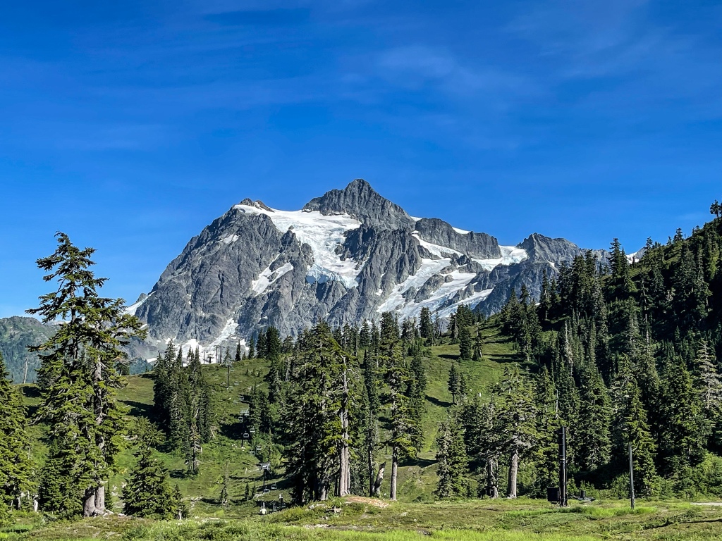
Back on our own now, we headed into the mountains again for some serious hiking in the northernmost North Cascades. First scouting day took us all the way east on Mount Baker Highway, from Lyndon until it terminates at the National Park’s 4,800’ Heather Meadow Information Center and Bagley Lake Trailhead (halfway upslope to Mt. Baker). Learned that the road to Artist’s Point (drivable approach to highest trailhead allowing views of both Mt. Baker and Mt. Shuksan) was closed due to road collapse. Based on the too-heavy visitor traffic on this more developed section of the mountains, we opted to backtrack to Glacier Creek Road leading to Heliotrope Ridge. This would be our target trail for the next day and was def. the correct decision.
The top of Mt. Baker, rapidly losing its glaciers and snowcap. Basalt columns along the side of the mountain.
Next morning, we headed out to the trailhead early due to unseasonably warm temps. After a 40-min drive upslope to the trail, we put on boots and packs and hit the trailhead, immediately to be immersed in deep, green, aromatic and humid old-growth forest (delicious!) for 2.5 miles. We forded Glacier Creek twice before turning onto Climber’s Ridge to avoid a third, virtually impassable (hip-high and turbulent) creek crossing.
Incredible sphagnum moss blankets on all downed trees, gorgeously filtered sunlight on the forest trail, and when you gaze into the distance you can see the Canadian Cascades in British Columbia.
Heliotrope Ridge is the same route mountaineers take when they approach Mt. Baker to summit from the west toward Coleman Glacier. Climber’s Ridge is about twice as steep as the first wooded section, and is fully exposed to daylight, flies, and other nuisances. Wouldn’t have missed the 1,800-foot ascent for the bittersweet thrill of seeing dozens of rivulets and falls coming in torrents off the melting glaciers, but it pretty much kicked our butts because we hadn’t been out hiking for more than 2 gentle miles at a time with our granddaughter. Felt close to sobs because of the climate destruction. It’s annoying how quickly conditioned legs fall out of shape! We’re sore and creaky today. This was a spectacular hike, and well, well worth the 4.25 hours up on the trail. Hoping to come back to the area to soak up more hike time. Quite a shock, though, to see Mt. Baker so bare of its snow cap – all due to temps in the 110-degree range in the surrounding valleys during July. Tragic to see the area getting fried to a dry crisp. Bonus points: on the dirt road back down to Mt. Baker Hwy, we noticed something sweeping long and low over the road. It landed in a tree right next to us, so we got a few pix and just gloried in the bird’s beauty. Once home, we confirmed it as a barred owl!!
One more hike in this part of North Cascades came today, and it was a mild one indeed. We moved down to Concrete, WA, (south side of North Cascades) to try for the trails just west of where we visited last time… but now thick smoke from British Columbia’s forest fires is blanketing the area, so there are NO sight lines to Mt. Baker or any other slopes further away than ½ mile. Instead of enjoying far vistas from the trails, we took a short 3-miler along Baker River to again see the deluge of water coming down from Mt. Baker (gigantic 1 million-year-old shield volcano) and Mt. Shuksan (smaller, 10 million-year-old broken-topped shield volcano). The nearly flat walk was just what we needed today, and we’ll be heading down to Ellensburg tomorrow to get halfway to Spokane, get out of the area heat plague, and slowly work our way back to Glacier NP.
Drive to Ellensburg was very hazy (due to forest fires) and quiet (took Hwy 9 south instead of I-5). Landed at Glory Farm, a hobby farm offered as a Hip Camp boondocking spot. Lovely owners let us know we were their first (!!) guests since very recently joining the Hip Camp network. Pat and Ellen Walton and a variety of resident animals greeted us, reminding us of time with the alpacas and horses on the Olympic Peninsula. Quiet night in farm country, followed by 2 miles on a hot and humid hike down the Palouse-to-Cascades State Park Trail before breaking camp to head east on I-90 to Spokane.
Underway we stopped briefly to see the Wild Horse Monument and the capacious Columbia River gorge banks.
It’s always fun to watch the landscape morph from treed mountain slopes to dry sagebrush hills to irrigated horse hayfields (!) to sweet corn and potatoes on high flat plains. We’ve seen millions of timothy and alfalfa bales under canopy and pole building storage here. Turns out that central Washington is a key (and choice) hay source for horse and cattle ranches in Japan! We’re amazed!!
Update: heard today that a wildfire has blown into Ellensburg from the west and now people are evacuating. How tragic!!!!
As we’ve driven across central and now eastern Washington, familiar geology appears. The gorgeous rolling hills of the northern Palouse, periodic lava outcroppings, occasional basalt columns. It’s all the pre-history of the land, from 17 million years ago when volcanic eruptions spread lava folds over the plains, then the glaciers came and did some gentle carving, followed by the colossal flooding of glacial lake Missoula which spread loess over the hills. And then the Columbia River did her work, carving a deep gorge through the land. All there to see.
Now in Spokane, where the temps are still high and the wildfire smoke still hangs in the air. Had planned a 5-miler up on Iller Creek, but seems we still need some rest to bounce back to full energy. So, we’ll putter around home base instead, and hope to hike tomorrow. And wouldn’t you know it? There’s now a forest fire northwest of town here, too. You cannot avoid them this summer in the PNW.
We did drive out to a Japanese garden landscaper, Dave, who also does Bonsai and who sold us some tools to give to our daughter for use on the Bonsai we bought in Seattle for her birthday. Our jaws dropped as we came around the corner to his backyard. Holy Hannah!!! He’s been working on his own garden for the past 20 years. The trees and ornamental bushes are stunning. What a peak experience. He recommended we check out the Japanese garden at Manito Park in south Spokane. Planning now to go there tomorrow!!! More thereafter.
Manito Park was to be one half of our day in Spokane. Turns out it was 90% of the engaging sights we saw. It happens.
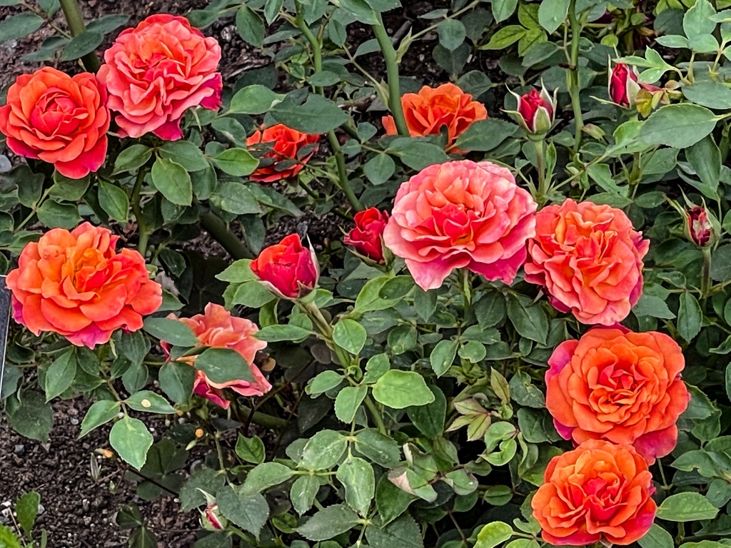
A stroll through the Rose Garden, Perennial Garden and Japanese Garden in the park was well worth the drive south of the city, even though, as Dave had warned us, it was not as meticulously trimmed or tidied as his large garden in Spokane Valley. But it has all the right stuff and if the city hired two more gardeners for upkeep, we’re sure it could be best-in-class. Needs just a little more love. We are reminded of how splendid the Portland Rose and Japanese Gardens were, and Dave also informed us that they are #1 in the nation. See them if you can.
The second half of the day was a disappointment built on a misunderstanding. We went to the Northwest Museum of Art and Culture, knowing that they had inherited a large collection of indigenous artifacts and art from an area museum that ran out of funds before it could open. We also assumed that a museum featuring art and culture would have some art and cultural exhibits, representing the area. Wrong on both counts. Apparently, the large native collection is currently archived, with no plans for a permanent exhibit, and apart from a temporary exhibit featuring John J Audubon’s bird portraits and a children’s exhibit showcasing native knowledge of herbs and plants and how western medicine has put that knowledge to use, there was nothing to see. What a shame. Beautiful building, lovely neighborhood, but something is badly missing from their formula for success.
Our last day in Spokane included a 4.5 mile hike up Iller Creek in a conservation reserve. Very nice, somewhere between easy and moderate. A few rocky areas in the path, but nothing we’d call challenging. Got some nice views of the urban bowl of Spokane City. And collected some Spruce needles from the campgrounds’ groundskeepers so that I could put them in an aromatic sachet – heavenly! That wraps up our visit here.
We are now in North Missoula, MT., getting ready for an awesome hike tomorrow up Rattlesnake Creek Trail, the quintessential Missoula hiking trail. Just as we drove up our exit from the highway, we saw a contingent of firefighters from Texas A&M. We waved, they nodded. We had wanted to visit the Smokejumpers’ Museum here, but it’s closed – we suspect it’s because they cannot take time away from firefighting to lead tours in this “Wildfire Everywhere” summer.
I have had a soft spot for this area since I first heard Kim Williams, a wildlife conservationist, reporting from here in her inimitable soft, engaging voice on NPR. And now Missoula actually has a trail named after Kim. How great is that?
We hit Rattlesnake at 9:30am because temps were to be moderate all day. What a well-maintained path! Heavily used by bikers, runners and their dogs. Decided to head up Spring Creek Gulch (9 miles RT) because we could get some elevation and a narrower trail than the rehabbed railbed. Not a particularly fabulous route for views, despite our 1,362’ gain, but doing it was important for us, to prepare for Glacier National Park’s upcoming 10-milers. Other than squirrels, no wildlife was seen, but the photo at the trailhead showed a mama bear and FOUR(!!) cubs from this season calling Rattlesnake Creek area home, so we know they’re here. Certainly saw plenty of huckleberry, currant and thimbleberry bushes, so they’ve got that abundance to snack on. On our drive away from the recreation area, we hit a gully washer – our second rain on the road since June 23!!
Last adventure in Missoula this time was a mild one: the Saturday Farmer’s Market. Actually, Missoula has three of them, but we only stopped at one. Got our greens on. The bags of huckleberries being sold at every other stand were amazing, and the price even more so. $10/hlf pound! $95 for 5 pounds! Harvested and in the bag, they really look nothing like blueberries, but we suspect no one grows blueberries around here, so wild hucks are it. Finally found some decent sweet corn (white), late season strawberries and Asian eggplant. Gonna have a nice Korean eggplant sauce over rice tonight!! Also saw Brennan’s Wave downtown, a manmade surfing wave for those craving a bit of ocean in MT.
Folks in the PNW seem to have a nice custom. For those with cutting gardens, they arrange lovely bouquets and put them out in an honor system display for commuters to snarf up on their way home. Such bright, cheery flowers have great appeal, and it seems to go over very well with locals and tourists alike.
Final parting note: we drove north on US 93 tonight to see the sunset from Jocko Canyon (due north of Missoula on Flathead Indian land). This lookout is reputed to be spectacular. Had to turn around halfway there due to a 3,600-acre wildfire in our path. So tragic to see so many fires burning, they are seemingly everywhere.
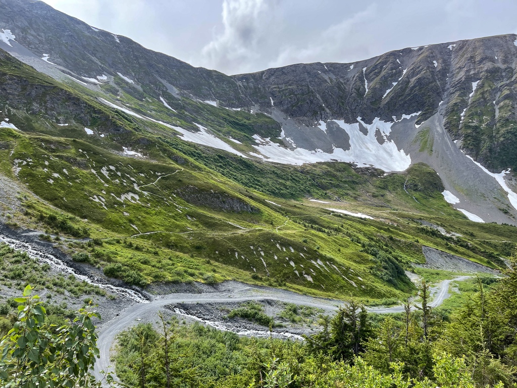
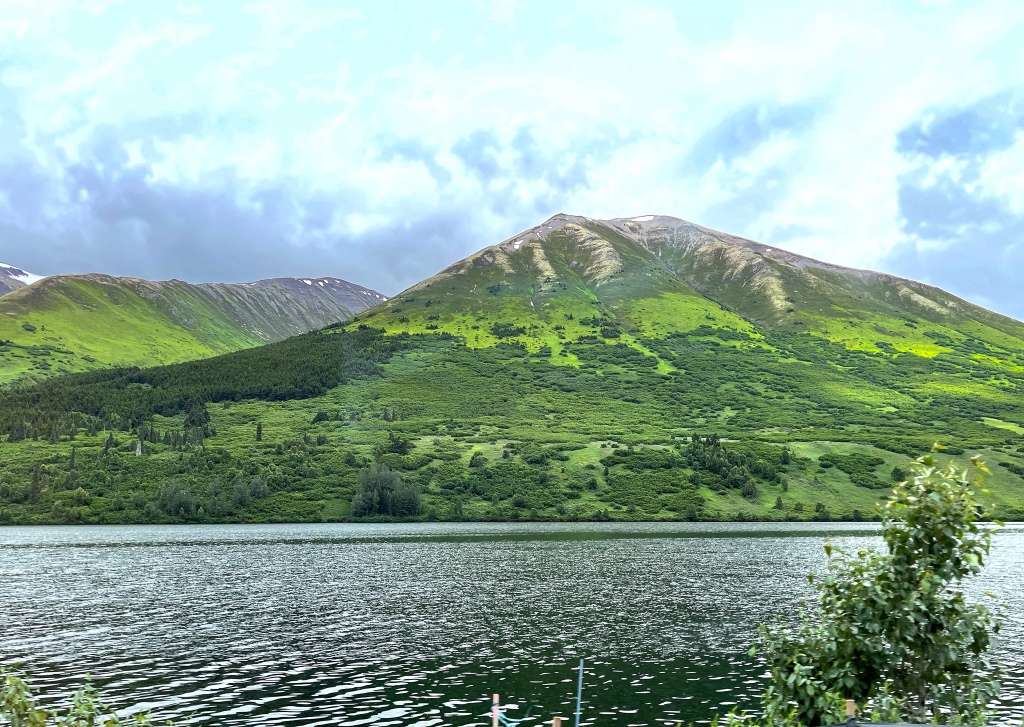
After another glorious drive along the 30-mile length of Flathead Lake, we’re at Glacier National Park. To be fair, it’s a good distance further than Flathead Lake to get to the East side of the park, but a lot of that is through forest, which we don’t mind at all!
Beautiful Flathead Lake, looking mysterious as a Scottish Loch on an ominous rainy morning.
What folks have said about Glacier this year is true: long distance views can be obscured by fire smoke, depending on wind direction. But it’s not as bad right now as it was earlier in July and August…we can at least see the mountains, which has apparently been impossible for weeks. We’re staying on the Blackfoot Reservation, private campground, and hope to see the Museum of the Plains Indian before we leave to move north. The goal of this visit is to see and hike the Two Medicine Lake and Many Glacier parts of the park, which were closed last time due to COVID and the threat of disease to the Blackfoot. Even though the Delta Variant has infections again on the rise, the reservation is still open, as residents are 95% vaccinated. We’re masked for the duration.
Two short hikes today: Paradise Point and Aster Meadow. Both heavily trafficked, but great trails with lush vegetation, beautiful marshes and beaver ponds. Paradise Point got us up close to Lower Two Medicine Lake and a 100% full-on wild view of the mountains looming over the lake. On the way to Aster Meadow, we met up with one of the most gregarious park rangers ever, a Blackfoot ranger named Carlson First Strike, who regaled us with his experiences in the park and recommended we get to the Going-to-the-Sun Road between 5 and 6am to have any hope of getting a parking spot for the two hikes we want to do there. We do have a reservation that allows us to take the road (otherwise one is relegated to the shuttle), but parking is reputed to be the limiting factor this year. Yikes. Oh well, we’ve done 4:30am reveille before, can do it again.
Well, happy birthday to me!!! It’s my 67th today, and we did all of No Name Lake Trail, nearly 10 miles and nearly 1,000 feet of elevation gain. But that’s not the half of it. What a pristine, beautiful path was laid out before us on this path. Lots of level track with no rocks allowed us to send our eyes elsewhere, and we rubbernecked a LOT. Wouldn’t you if you saw a young Black Bear about a half mile from the start of the trail? That was a first for us, and with some loud persuasion, the teenager (only 80 feet away) lumbered into the bush and moved downslope towards the lake.
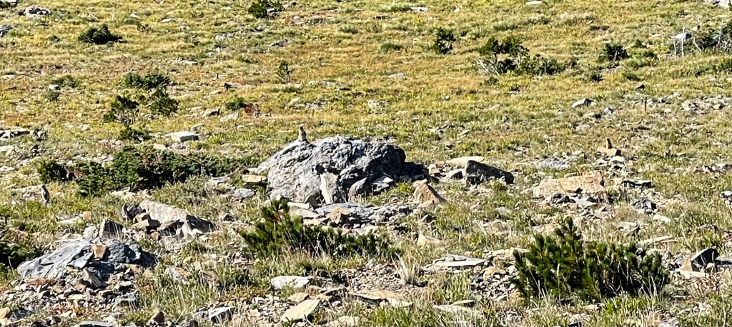
This trail runs 2.5 miles along Lower Two Medicine Lake and some of the most beautiful nearly vertical sedimentary rock faces in the park, and then it abruptly heads upslope where most of the elevation is gained. We heard a Bull Moose in rut, way down by the lake. Lots and lots of Huckleberries, Pearly Everlasting, Thimbleberries, Mountain Ash, Beargrass and heavily-laden Elderberries along the way. A little huffing and puffing later and we ended up at the lake with the funny name. We joked that it could be called No Moose Lake, as we doubted that any moose would venture up to 6,000 feet altitude in search of food.
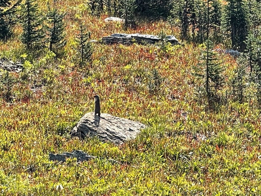
But the joke was on us, as we finished our lunch and said goodbye to the pikas dancing around the trail. Shortly after starting back, we came upon a moose cow leisurely munching on head-high bushes 15 feet off the trail. Apparently at this time of year they migrate from the wet grasses of the lakes to the forested stretches at higher elevations. How exciting!!! But wait, there’s more!!
Another 2 miles down the trail we came around a corner and came face-to-face (ok, with 20 feet separation) with a Bull Moose! Another munching session off the trail, and when we turned around, there was his girlfriend on the other side of the trail, enjoying her own snack of woody brush. What the heck brought all these critters out to greet us??? But wait, there’s more!!
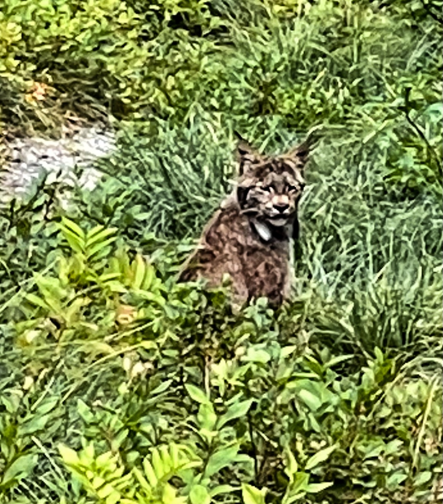
About ¾ of a mile from the end of the trail, again we came around a bend and in the middle of the path, 25 feet ahead, sat a Canadian LYNX (one of only 100 reputed to be on the US side of the border!!!) We were simply gobsmacked, as we’d never heard of anyone seeing a Lynx in the park before, and it seemed a strange time of day for a nocturnal hunter to be out. He or she continued to sit in the trail and nonchalantly look around. Seeing us was no big deal to the cat. We eventually had to bang together our hiking poles to encourage it to move along, and upon hearing the noise, it slowly sauntered into the bush. We could still see it as we passed by. The serious wildlife photographer we met just 70 paces further along was mighty frustrated that we saw the critters and he did not!!
Altogether a mythic, epic hike. A peak experience, as we like to call ‘em. We’re still pinching ourselves over it – was it real? But we’ve got the pix (all except the bear photo, which does not exist because we opted to focus full concentration on shooing him away) to prove it. We’ll never forget my birthday hike of 2021!!
Thus ends Part 1 of our 13th Adventure in nature. WordPress is acting strangely as I write these posts, and the only resolution to repeated shutdowns of the composing app is to write shorter posts. Please stay tuned for Part 2, coming in the next few days.